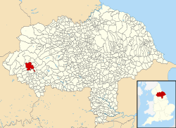
Malham Moor
| Malham Moor | |
|---|---|
| Civil parish | |
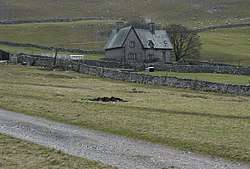 Farm in Malham Moor | |
 | |
| Coordinates: 54°06′18″N 2°10′41″W / 54.105°N 2.178°WCoordinates: 54°06′18″N 2°10′41″W / 54.105°N 2.178°W | |
| Country | England |
| Primary council | Craven |
| County | North Yorkshire |
| Region | Yorkshire and the Humber |
| Status | Parish |
| Government | |
| • Type | Parish Council |
| • EU Parliament | Yorkshire and the Humber |
| Population (2015) | |
| • Total | 70 |
Malham Moor is a civil parish in the Craven district of North Yorkshire, England. Its population was estimated at 70 in 2015. [1]
It has a joint parish council, Kirkby Malhamdale Parish Council, with the parishes of Malham, Kirkby Malham and Hanlith.[2]
.jpg)
There is no village in the parish. The parish includes scattered farms and houses, Malham Tarn and large areas of moorland, including Fountains Fell. The upland area identified on Ordnance Survey maps as Malham Moor lies outside the parish, to the east. It is north west of Threshfield along Malham Moor Lane. Its summit is at 411m.(SD952648)
Malham Moor was historically a township in the ancient parish of Kirkby Malham in the West Riding of Yorkshire.[3] It became a civil parish in 1866,[4] and in 1974 was transferred to the new county of North Yorkshire.
References
- ↑ "Population Estimates" (PDF). North Yorkshire County Council. 2015. Retrieved 30 October 2017. In the 2011 Census the population was included in the civil parish of Malham and not counted separately.
- ↑ "Kirkby Malhamdale Parish Council". malhamdale.com. Retrieved 4 February 2016.
- ↑ Genuki website
- ↑ Vision of Britain website