Makronisos
| Native name: Μακρόνησος | |
|---|---|
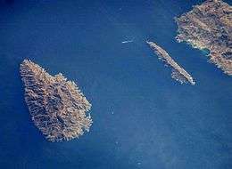 Kea (left) and Makronisos from the International Space Station | |
 | |
| Geography | |
| Coordinates | 37°42′N 24°07′E / 37.70°N 24.12°ECoordinates: 37°42′N 24°07′E / 37.70°N 24.12°E |
| Archipelago | None |
| Area | 20 km2 (7.7 sq mi) |
| Highest elevation | 281 m (922 ft) |
| Administration | |
|
Greece | |
| Region | South Aegean |
| Regional unit | Kea-Kythnos |
| Demographics | |
| Population | 5 (2001) |
| Postal code | 840 02 |
| Area code(s) | 22880 |
Makronisos (Greek: Μακρόνησος, lit. Long Island), or Makronisi, is an island in the Aegean sea, in Greece, notorious as the site of a political prison from the 1940s to the 1970s. It is located close to the coast of Attica, facing the port of Lavrio. The island has an elongated shape, 13 km (8 mi) north to south, around 500 m (1,640 ft) east to west, and its terrain is arid and rocky. It is the largest uninhabited Greek island.
It is part of the Kea-Kythnos regional unit and in the municipality of Kea.
History
In ancient times the island was called Helena (Ancient Greek: Ἑλένη), and was situated so as to protect the harbours of Thoricus and Sunium. It was also called Macris (Μάκρις), from its length.[1] Strabo describes it as 60 stadia in length; but its real length is seven geographical miles (12 km).[2] It was uninhabited in antiquity, as it is at the present day; and it was probably only used then for the pasture of cattle. Both Strabo and Pausanias derive its name from Helen of Troy, the wife of Menelaus: the latter writer supposes that it was so called because Helen landed here after the capture of Troy; but Strabo identifies it with the Homeric Cranae, to which Paris fled with Helen,[3] and supposes that its name was hence changed into Helena. There cannot, however, be any doubt that the Homeric Cranaë was opposite Gythium in Laconia.[4][5][6][7]
It was used as a military prison island from the time of the Greek Civil War until the restoration of democracy, following the collapse of the Regime of the Colonels in 1974. Because of its history, it is considered as a monument of the civil war era; therefore the island and the original structures on it are protected from alteration.
The Kea Channel between Makronisos and neighbouring Kea was the site of the sinking, in 1916, of HMHS Britannic, sister ship of the RMS Titanic.
Films
- Le Nouveau Parthénon (1975) by Kostas Chronopoulos and Giogos Chryssovitsianos.
- Happy Day (1976) by Pantelís Voúlgaris.
- Makronissos (2008), by Ilias Giannakakis and Evi Karabatsou.
- Like Stone lions at the gateway into night (2012), by Olivier Zuchuat
References
- ↑ Stephanus of Byzantium. Ethnica. s.v. Ἑλένη.
- ↑ Strabo. Geographica. ix. p.399. Page numbers refer to those of Isaac Casaubon's edition.
- ↑ Homer. Iliad. 3.445.
- ↑ Strabo. Geographica. ix. p.399, x. p. 485. Page numbers refer to those of Isaac Casaubon's edition.
- ↑ Pausanias. Description of Greece. 1.35.1. , 8.14.12
- ↑ Pomponius Mela. De situ orbis. 2.7.
- ↑ Pliny. Naturalis Historia. 4.12.20.
- Hamilakis, Yannis, "The Other 'Parthenon': Antiquity and National Memory at Makronisos", Journal of Modern Greek Studies 20:2 (October 2002), pp. 307–338.
![]()