Maimajhuwa
| Maimajhuwa माइमझुवा | |
|---|---|
| Village Development Committee | |
 Maimajhuwa Location in Nepal | |
| Coordinates: 27°05′N 87°58′E / 27.08°N 87.96°ECoordinates: 27°05′N 87°58′E / 27.08°N 87.96°E | |
| Country |
|
| Zone | Mechi Zone |
| District | Ilam District |
| Population (1991) | |
| • Total | 3,543 |
| Time zone | UTC+5:45 (Nepal Time) |
Maimajhuwa is a town and Village Development Committee in Ilam District in the Mechi Zone of eastern Nepal. At the time of the 1991 Nepal census it had a population of 3,543 persons living in 578 individual households.[1]
Maimajhuwa is known as village of santapur, from where we can sunrise like shree antu illam, it's also one historical and some where we can get tourism benefit like other.
References
- ↑ "Nepal Census 2001". Nepal's Village Development Committees. Digital Himalaya. Archived from the original on 12 October 2008. Retrieved 17 September 2008.
External links
Headquarter: Ilam | ||
| Rural Municipalities | 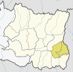 | |
| Municipalities | ||
This article is issued from
Wikipedia.
The text is licensed under Creative Commons - Attribution - Sharealike.
Additional terms may apply for the media files.