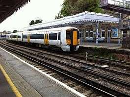
Maidstone West railway station
| Maidstone West | |
|---|---|
 | |
| Location | |
| Place | Maidstone |
| Local authority | Maidstone |
| Grid reference | TQ755553 |
| Operations | |
| Station code | MDW |
| Managed by | Southeastern |
| Number of platforms | 2 |
| DfT category | E |
|
Live arrivals/departures, station information and onward connections from National Rail Enquiries | |
| Annual rail passenger usage* | |
| 2012/13 |
|
| – Interchange |
|
| 2013/14 |
|
| – Interchange |
|
| 2014/15 |
|
| – Interchange |
|
| 2015/16 |
|
| – Interchange |
|
| 2016/17 |
|
| – Interchange |
|
| History | |
| 25 September 1844 | Opened (Terminus) |
| 18 June 1856 | Through station opened |
| National Rail – UK railway stations | |
| * Annual estimated passenger usage based on sales of tickets in stated financial year(s) which end or originate at Maidstone West from Office of Rail and Road statistics. Methodology may vary year on year. | |
|
| |

Maidstone West railway station is one of three railway stations which serve the town of Maidstone, the county town of Kent, England. It is on the Medway Valley Line, 42 miles 36 chains (68.3 km) from London Charing Cross via Strood and situated between Maidstone Barracks and East Farleigh. The station and all trains that call are operated by Southeastern.
History
Due largely to opposition from the town's merchants, and the fear expressed by the then Mayor that "Maidstone will be ruined as a commercial town",[1] the town was bypassed when the South Eastern Main Line opened by the South Eastern Railway (SER) in 1842. The line ran approximately eight miles to the south, with the nearest station being at Maidstone Road (later renamed Paddock Wood). On 25 September 1844, a branch line was opened from Paddock Wood to Maidstone West. This was extended further up the Medway Valley to the North Kent Line at Strood on 18 June 1856. The main station building is believed to date from this time.[2]
Maidstone West has a signal box — located at the southern end of the station — which is used as the point at which the mileage measurements and the "Up" and "Down" directions to London change.[3] South of the signal box, the distance from London is measured via Paddock Wood, and the Up (towards London) direction is southbound. From the signal box northwards, however, mileages are measured via Strood and the northbound line is the Up direction.[4] On 3 August 1944, the signal box was severely damaged when a doodlebug landed nearby. Seven people were killed, as well as two dray horses belonging to Maidstone brewers Fremlins. The signalbox was repaired and returned to service.[5]
Just south of Maidstone West was a station at Tovil (TQ 752 549). Passenger services ceased on 15 March 1943. A short line ran on a bridge across the River Medway to a goods station at Tovil Goods (TQ 754 545) until 3 October 1977, from which point the branch line closed completely.[6]
Services
The typical off-peak service from the station is one train per hour to Paddock Wood and Tonbridge, and two trains an hour to Strood. Connections to London are available from any of these three stations.
Four trains each way per day using Class 395 Javelin units operate between Maidstone West and St Pancras via Strood and Gravesend.[7]
| Preceding station | Following station | |||
|---|---|---|---|---|
| Maidstone Barracks | Southeastern Medway Valley Line |
East Farleigh | ||
| Snodland | Southeastern High Speed 1 (limited peak services) |
Terminus | ||
| Disused railways | ||||
| Terminus | Headcorn & Maidstone Junction Light Railway |
Tovil Goods | ||
References
- ↑ J M Russell:The History of Maidstone published by John Hallewell Publications, 1978 (reprint of 1st Ed. 1881)
- ↑ Body, Geoffrey. PSL Field Guide – Railways of the Southern Region (1984), page 128. Patrick Stephens Ltd, Cambridge. ISBN 0-85059-664-5
- ↑ Marsden, Colin J. Route Recognition: 1 — Southern Region (1985), pages 124-125. Ian Allan Ltd, Shepperton. ISBN 0-7110-1553-8
- ↑ Body, page 128.
- ↑ Angela Cole (30 July 2010). "Deadly doodlebug attack on signal box:a first-hand account". Kent Messenger. p. 38.
- ↑ Body, page 128
- ↑ "High-speed trains start from Maidstone". Kent Messenger Group. Retrieved 23 May 2011.
External links
- Train times and station information for Maidstone West railway station from National Rail
Coordinates: 51°16′14.50″N 0°30′56.50″E / 51.2706944°N 0.5156944°E