Chestfield & Swalecliffe railway station
| Chestfield and Swalecliffe | |
|---|---|
 | |
| Location | |
| Place | Swalecliffe |
| Local authority | City of Canterbury |
| Grid reference | TR136668 |
| Operations | |
| Station code | CSW |
| Managed by | Southeastern |
| Number of platforms | 2 |
| DfT category | E |
|
Live arrivals/departures, station information and onward connections from National Rail Enquiries | |
| Annual rail passenger usage* | |
| 2012/13 |
|
| 2013/14 |
|
| 2014/15 |
|
| 2015/16 |
|
| 2016/17 |
|
| History | |
| Key dates | Opened 6 July 1930[1] |
| National Rail – UK railway stations | |
| * Annual estimated passenger usage based on sales of tickets in stated financial year(s) which end or originate at Chestfield and Swalecliffe from Office of Rail and Road statistics. Methodology may vary year on year. | |
|
| |
Chestfield and Swalecliffe railway station is on the Ramsgate branch of the Chatham Main Line in England, serving the villages of Chestfield and Swalecliffe, Kent. It is 60 miles 45 chains (97.5 km) down the line from London Victoria and is situated between Whitstable and Herne Bay.
The station and all trains that call are operated by Southeastern.
It was originally opened as "Swalecliffe Halt" on 6 July 1930 by Southern Railway.[1] It was later renamed "Chestfield & Swalecliffe Halt", shortened to "Chestfield" in 1987 and reverted to "Chestfield and Swalecliffe" in 1989. Although the railway station itself actually lies in the village of Swalecliffe, nearby Chestfield is substantially the bigger village.[1]
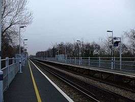
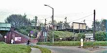
There are waiting shelters and an Up side booking office, which is open for a few hours each morning; the platforms are built of rails and sleepers. The "down" ticket office was burnt down by vandals in 1989.[1]
Services
The typical off-peak service from the station is
- 1 tph to London Victoria via Chatham and Bromley South (Main Line)
- 1 tph to Ramsgate via Margate (Main Line)
References
External links
- Train times and station information for Chestfield & Swalecliffe railway station from National Rail
| Preceding station | Following station | |||
|---|---|---|---|---|
| Whitstable | Southeastern Chatham Main Line - Ramsgate Branch |
Herne Bay | ||
Coordinates: 51°21′36.81″N 1°4′0.70″E / 51.3602250°N 1.0668611°E