Lycia et Pamphylia
| Provincia Lycia et Pamphylia ἐπαρχία Λυκίας και Παμφυλίας | |||||
| Province of the Roman Empire | |||||
| |||||
 | |||||
| Capital | Attalia | ||||
| Historical era | Antiquity | ||||
| • | Established | 74 | |||
| • | Disestablished | 325 | |||
| Today part of | |||||
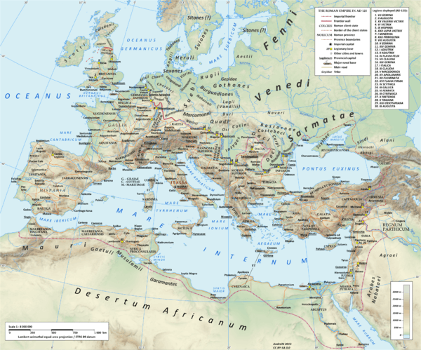
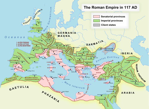
Lycia et Pamphylia was the name of a province of the Roman empire, located in southern Anatolia. It was created by the emperor Vespasian (reigned AD 69- 79), who merged Lycia and Pamphylia into a single administrative unit.[1][2] In 43 AD, the emperor Claudius had annexed Lycia.[3][4] Pamphylia had been a part of the province of Galatia.
The borders drawn by Vespasian ran west of the River Indus (which flowed from its upper valley in Caria) from the Pisidian plateau up to Lake Ascanius (Burdur Gölü), to the south of Apamea. In the north and east it formed a line which followed the shores of the lakes Limna (Hoyran Gölü) and Caralis (Beyşehir Gölü), turned south towards the Gulf of Adalla (mare Pamphylium) and followed the Taurus Mountains (Toros Daǧlari) for some ten miles towards east up to Isauria. It then followed Cilicia Trachea to reach the sea to the west of Iotape. The borders were dawn taking into account geographical and economic factors. The whole of the basins of the rivers Xanthus, Cestrus (Ak Su) and Eurymedon (Köprü Irmak) were included. The main cities were at the mouth of the latter two rivers. In Pisidia e in Pamphylia they were in part followed by the few roads into the interior of Anatolia. The most important one was the road from Attalea (Antalya) to Apamea. In Lycia the road from Patara towards Laodicea on the Lycus followed the coast. Important cites were Side, Ptolemais, Gagae and Myra on the coast, Seleucia, inland and Cremna, Colbhasa and Comama,on the Pisidian Plateau, where Augustus had founded Roman colonies (settlements). on the Milyas plateau there were Oenoanda, Tlos, Nisa, Podalia, Termessus and Trebenna. Other important cities in Lycia were Pednelissus, Ariassus e Sagalassus; along the Eurymedon, Aspendus and Perge, which had a sanctuary of Artemis. The most important city in the region was Patara, at the mouth of the Xanthus.
Under the administrative reforms of emperor Diocletian (reigned AD 284-305), which doubled the number of Roman provinces by reducing their size, the Lycia et Pamphylia province was split into two separate provinces. The provinces were grouped into twelve dioceses which were under the four Praetorian prefectures of the empire. Lycia and Pamphylia were under of Diocese of Asia (Dioecesis Asiana), of the Praetorian Prefecture of Oriens (the East).
Governors
- Quintus Veranius 43-48
- Titus Clodius Eprius Marcellus 53-56
- Sextus Marcius Priscus 67-70[5]
- Marcus Hirrius Fronto Neratius Pansa 70-72
- Gnaeus Avidius Celer Fiscillinus Firmus 72-74
- Lucius Luscius Ocrea 74-76
- Marcus Petronius Umbrinus 76-78
- Titus Aurelius Quietus 78-81
- Gaius Caristanius Fronto 81-84
- Publius Baebius Italicus 84-87
- Gaius Antius Aulus Iulius Quadratus 89-93
- Lucius Domitius Apollinaris 93-96
- Lucius Julius Marinus Caecilius Simplex 96-99
- Gaius Trebonius Proculus Mettius Modestus 99-103
- Quintus Pompeius Falco 103-105
- Tiberius Julius Frugi 113-115
- Gaius Trebius Maximus 115-117
- Titus Pomponius Antistianus Funisulanus Vettonianus 117-120
- Gaius Valerius Severus 120-124
- Marcus Flavius Aper 124-127
- Sufenas Verus 127-130
- ?Mettius Modestus 130-133
- [Domiti]us Seneca 133-136
- Titus Calestrius Tiro Julius Maternus 136-138
- Gnaeus Arrius Cornelius Proculus 138-140
- Julius Aqui[linus] ? 140-?141/2[6]
- Decimus Junius Paetus ?141/2-?143
- Quintus Voconius Saxa Fidus ?143-147
- Gaius Julius Avitus 147-149
- Decimus Ruplius Severus 149-?151
- Julius Proculus (attested September 152)
- Gaius Septimus Severus (between 153 and 160)
- Publius Vigellius Saturninus 162/163-164/165
- Licinius Priscus (attested 23 March 178)
- Tiberius Pollenius Armenius Peregrinus 244
Notes
- ↑ Şahin, Sencer; Mustafa Adak (2007). Stadiasmus Patarensis. Itinera Romana Provinciae Lyciae. Ege Yayınları. pp. 85–93.
- ↑ Fatih Onur (2008). "Two Procuratorian Inscriptions from Perge". Gephyra. 5: 53–66.
- ↑ Suetonius, The Twelve Caesars; The Life of Claudius, 23.3
- ↑ Cassius Dio, Roman History, 60.17.3-4
- ↑ Unless otherwise stated, the names of the proconsular governors from 67 to 140 are taken from Werner Eck, "Jahres- und Provinzialfasten der senatorischen Statthalter von 69/70 bis 138/139", Chiron, 12 (1982), pp. 281-362; 13 (1983), pp. 147-237
- ↑ Unless otherwise stated, the names of the governors from 140 to 180 are taken from Géza Alföldy, Konsulat und Senatorenstand unter der Antoninen (Bonn: Rudolf Habelt Verlag, 1977), pp. 207-211
References
- Fatih Onur (2008). "Two Procuratorian Inscriptions from Perge". Gephyra 5: 53–66.
- Jones,A. H. M., The Cities of the Eastern Roman Provinces, Oxford University Press academic monograph reprints, 1998; ISBN 978-0199240098
- Şahin, Sencer Mustafa Adak (2007). Stadiasmus Patarensis. Likya Eyaleti Roma Yollari / Itinera Romana Provinciae Lyciae, Arkeoloji Sanat Yayinlari, 2011; ISBN 978-6053962670 (in Turkish)
- Syme R., "Galatia and Pamphylia under Augustus: The Governorships of Piso, Quirinius and Silvanus", Klio, 27 (1934), pp. 122–147;
- Syme R., "Pamphylia from Augustus to Vespasian", Klio, 30 (1937), pp. 227–231
|  | |
† Italy was never constituted as a province, instead retaining a special juridical status until Diocletian's reforms. | ||