Lundbreck Falls
| Lundbreck Falls | |
|---|---|
 | |
| Location | Pincher Creek M.D. No. 9, Alberta |
| Coordinates | 49°34′56″N 114°12′31″W / 49.58222°N 114.20861°WCoordinates: 49°34′56″N 114°12′31″W / 49.58222°N 114.20861°W |
| Total height | 12 m (39 ft) |
| Number of drops | 3 |
| Watercourse | Crowsnest River |
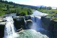
Lundbreck Falls is a waterfall of the Crowsnest River located in southwestern Alberta, Canada near the hamlet of Lundbreck.
It is located adjacent to where Highway 3A crosses the Crowsnest River, approximately 1.2 km (0.75 mi) off of the Crowsnest Highway (Highway 3), between Pincher Creek and Crowsnest Pass.[1] The falls have a drop of about 12 metres (39 ft).[2] Visitors can view Lundbreck Falls from the observation platform as well as hiking to below the falls.[3]
A day use area and an overnight campground are maintained at the falls site.[2]
References
- ↑ Google (February 24, 2017). "Lundbreck Falls" (Map). Google Maps. Google. Retrieved February 24, 2017.
- 1 2 "Lundbreck Falls Provincial Recreation Area". Alberta Parks. Retrieved February 24, 2017.
- ↑ "Lundbreck Falls". Travel Alberta. Retrieved February 24, 2017.
External links

This article is issued from
Wikipedia.
The text is licensed under Creative Commons - Attribution - Sharealike.
Additional terms may apply for the media files.