Lozisht
| Ignatówka (Lozisht) | |
|---|---|
| Shtetl (completely destroyed) | |
 Lozisht location east of Belzec in World War II | |
 Ignatówka (Lozisht) Location of eradicated town of Ignatówka (Lozisht) within present-day Ukraine | |
| Coordinates: 50°55′15″N 25°41′50″E / 50.92083°N 25.69722°ECoordinates: 50°55′15″N 25°41′50″E / 50.92083°N 25.69722°E | |
| Country |
Occupied Poland now, location in Ukraine |
| Founded | 1838, Russian Empire |
| Destroyed | 1942, during the Holocaust by bullets |
| Website |
heavensareempty |
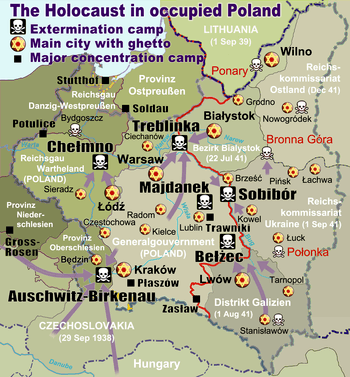
Ignatówka, also Lozisht,[1] was a Jewish shtetl (village) located in what is now western Ukraine but which used to be part of the Second Polish Republic before the Nazi-Soviet invasion of Poland in 1939. Ignatówka was bordering a Jewish shtetl in Zofjówka, located in the gmina Silno, powiat Łuck of the Wołyń Voivodeship, in prewar Poland.[2] The two villages were part of a joint Jewish community of Trochenbrod and Lozisht.[1]
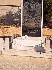
Ignatówka (Lozisht) was founded in 1838, and had grown to approximately 1,200 inhabitants by the beginning of World War II. Of those, only a few survived. Most of the Jews of Ignatówka died in a single killing spree along with the Jews of neighbouring Zofjówka (Trochenbrod) in the hands of local collaborators,[3] consisting mostly of the Ukrainian Auxiliary Police shooters who rounded up the prisoners in the presence of only a few German SS men. According to Virtual Shtetl over 5,000 Jews were massacred, including 3,500 from Zofiówka and 1,200 from Ignatówka, including some inhabitants of other nearby settlements.[4][5] The village was totally destroyed and now only fields and a forest can be seen there.
References
- 1 2 Beit Tal (2007), Trochenbrod & Lozisht community website. Internet Archive. See also: The Heavens Are Empty: Discovering the Lost Town of Trochenbrod by Avrom Bendavid-Val. A Lost History, official website. Internet Archive.
- ↑ Jagiellonian Digital Library (2016) [1936]. "Wołyński Dziennik Wojewódzki". Volume 1; 96 pages. Łuck, Urząd Wojewódzki Wołyński. Pos. 345 at page 63 in DjVu reader. Digital copy identifier: NDIGCZAS003514 (public domain). See also: Strony o Wołyniu (2008). "Zofjówka". Town description in the Polish language, with location map, statistical data, and a short list of prominent individuals. Wolyn.ovh.org.
- ↑ Eleazar Barco (Bork), Samuel Sokolow (April 22, 1999) [original material written before World War Two]. "Trochinbrod - Zofiowka". Translated from Hebrew by Karen Engel. Transcribed by Gary Sokolow (tripod.com, Internet Archive). Archived from the original on 2 March 2014. Retrieved 24 December 2014.
- ↑ Beit Tal (2010). "Zofiówka". POLIN Museum of the History of Polish Jews. Archived from the original on 30 December 2014. Retrieved 25 December 2014.
- ↑ Beit Tal (2014). "Truchenbrod – Lozisht". The Nahum Goldmann Museum of the Jewish Diaspora. Archived from the original on 2014-08-10 – via Internet Archive.
- The tree and its roots האילן ושורשיו : ספר קורות ט״ל : זופיובקה־־איגנטובקה (in Hebrew). 1988. LCCN 88195445. a book about the combined towns of Trochenbrod and Lozisht