Loyalsock Township, Lycoming County, Pennsylvania
| Loyalsock Township, Pennsylvania | |
|---|---|
| Township | |
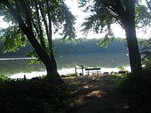
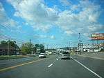 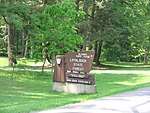 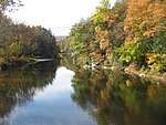  Clockwise from top: Golden Strip; Loyalsock State Forest; Loyalsock Creek; Loyalsock Train Bridge over Loyalsock Creek. | |
| Nickname(s): Sock Township, Sock, The Sock | |
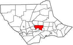 Location within Lycoming | |
 Loyalsock Township Location in Pennsylvania  Loyalsock Township Loyalsock Township (the US) | |
| Coordinates: 41°16′34″N 76°59′10″W / 41.276°N 76.986°WCoordinates: 41°16′34″N 76°59′10″W / 41.276°N 76.986°W | |
| Country |
|
| State |
|
| County | Lycoming |
| Settled | 1768 |
| Incorporated | 1786 |
| Area[1] | |
| • Total | 21.50 sq mi (55.67 km2) |
| • Land | 21.15 sq mi (54.78 km2) |
| • Water | 0.34 sq mi (0.89 km2) |
| Elevation | 1,770 ft (524 m) |
| Population (2010) | |
| • Total | 11,026 |
| • Estimate (2016)[2] | 11,148 |
| • Density | 527.07/sq mi (203.50/km2) |
| Time zone | Eastern (EST) |
| • Summer (DST) | EDT |
| Area code(s) | 570 |
| FIPS code | 42-081-45224 |
Loyalsock Township is a township in Lycoming County, Pennsylvania, United States. The population was 11,026 at the 2010 census. It is part of the Williamsport, Pennsylvania Metropolitan Statistical Area. It is the second largest municipality in Lycoming County in terms of population behind the county seat Williamsport.
The township was settled in 1768 and incorporated just less than 20 years later in 1786. The township is well known for its school district all schools in the district rank in the top 150 in the state in test scores and teacher preparedness. Loyalsock Township School District consists of a high school, middle school and elementary.
Where the township is located next to the West Branch Susquehanna River it is a hot bed for Indian fossils. A good example is Canfield island here archaeologists have found over 1,500 pieces of Indian pottery, weaponry and other artifacts. Some being displayed in collections in Philadelphia, Pittsburgh, New York City, however most can be found at local museums in nearby Williamsport.
History
Loyalsock Township was formed from Muncy Township in February 1786 by the Northumberland County court. This was nine years prior to the formation of Lycoming County. The township was originally bounded by the West Branch Susquehanna River to the south, Loyalsock Creek was the eastern limit and Lycoming Creek was the western limit.story">Meginness, John Franklin (1892). "Loyalsock, Hepburn, and Eldred". History of Lycoming County, Pennsylvania: including its aboriginal history; the colonial and revolutionary periods; early settlement and subsequent growth; organization and civil administration; the legal and medical professions; internal improvement; past and present history of Williamsport; manufacturing and lumber interests; religious, educational, and social development; geology and agriculture; military record; sketches of boroughs, townships, and villages; portraits and biographies of pioneers and representative citizens, etc. etc (1st ed.). Chicago: Brown, Runk & Co. ISBN 0-7884-0428-8. Retrieved 2007-04-25. (Note: ISBN refers to Heritage Books July 1996 reprint. URL is to a scan of the 1892 version with some OCR typos).
</ref>

In the American Revolutionary War, settlements throughout the Susquehanna valley and what was to become Loyalsock Township were attacked by Loyalists and Native Americans allied with the British. After the Wyoming Valley battle and massacre in the summer of 1778 (near what is now Wilkes-Barre) and smaller local attacks, the "Big Runaway" occurred throughout the West Branch Susquehanna valley. Settlers fled feared and actual attacks by the British and their allies. Homes and fields were abandoned, with livestock driven along and a few possessions floated on rafts on the river east to Muncy, then further south to Sunbury. The abandoned property was burnt by the attackers. Some settlers soon returned, only to flee again in the summer of 1779 in the "Little Runaway". Sullivan's Expedition helped stabilize the area and encouraged resettlement, which continued after the war.[3]
Isaac and William McKinney, father and son, built the McKinney Iron Works along Lycoming Creek in western Loyalsock Townshop between 1825 and 1830, when they built a forge, in an area known as Heshbon Park. Their operation was expanded in 1836 with the construction of an iron furnace and further still in 1841 when a rolling mill was added to the complex. Iron ore was transported down the West Branch Susquehanna River Valley and up Lycoming Creek to the iron works from Centre County. The McKinney's effort was ultimately unsuccessful. The efforts of two more iron masters also failed. The iron works was largely destroyed by a flood in 1865.
Daniel Hughes was a conductor in the Underground Railroad based in Loyalsock Township. He was the owner of a barge on the Pennsylvania Canal and transported lumber from Williamsport on the West Branch Susquehanna River to Havre de Grace, Maryland.[4] Hughes hid runaway slaves in the hold of his barge on his return trip up the Susquehanna River to Lycoming County where he provided shelter on his property near the Loyalsock Township border with Williamsport before moving further north and to eventual freedom in Canada.[5] Hughes' home was located in a hollow or small valley in the mountains just north of Williamsport. This hollow is now known as Freedom Road having previously been called Nigger Hollow.[5] In response to the actions of concerned African American citizens of Williamsport, the pejorative name was formally changed by the Williamsport City Council in 1936.[4]
Today, the flood plain between Williamsport and Montoursville is densely populated with family residences and a shopping district known as the "Golden Strip" along East Third Street. The northern and western parts of the township are less heavily populated but still there are many family homes and small businesses. The population of Loyalsock Township has grown to 10,876 (2000 census) this is up from 2,498 (1890 census).
Geography and climate
Loyalsock Township is bordered by Montoursville, Fairfield and Upper Fairfield Township to the east. These eastern borders are formed by Loyalsock Creek. The township is bordered by Williamsport and the West Branch Susquehanna River to the south (with Armstrong Township south of the river). Williamsport also forms the eastern border along with Lycoming Creek which is the dividing line between Loyalsock and Old Lycoming Township. The townships of Hepburn and Eldred form the northern border.[6] As the crow flies, Lycoming County is about 130 miles (209 km) northwest of Philadelphia and 165 miles (266 km) east-northeast of Pittsburgh.
According to the United States Census Bureau, the township has a total area of 21.2 square miles (55.0 km2).21.0 square miles (54.4 km2) of it is land and 0.2 square miles (0.6 km2) of it (1.13%) is water.
Climate
| Climate data for Williamsport Regional Airport, Pennsylvania (1981–2010 normals, extremes 1895–present) | |||||||||||||
|---|---|---|---|---|---|---|---|---|---|---|---|---|---|
| Month | Jan | Feb | Mar | Apr | May | Jun | Jul | Aug | Sep | Oct | Nov | Dec | Year |
| Record high °F (°C) | 70 (21) |
71 (22) |
87 (31) |
96 (36) |
96 (36) |
104 (40) |
106 (41) |
103 (39) |
102 (39) |
93 (34) |
83 (28) |
70 (21) |
106 (41) |
| Average high °F (°C) | 34.2 (1.2) |
38.0 (3.3) |
47.9 (8.8) |
60.9 (16.1) |
71.5 (21.9) |
79.7 (26.5) |
83.6 (28.7) |
81.6 (27.6) |
73.5 (23.1) |
62.0 (16.7) |
49.9 (9.9) |
38.1 (3.4) |
60.1 (15.6) |
| Average low °F (°C) | 19.3 (−7.1) |
21.4 (−5.9) |
28.6 (−1.9) |
38.9 (3.8) |
47.9 (8.8) |
57.6 (14.2) |
61.9 (16.6) |
60.7 (15.9) |
53.1 (11.7) |
41.5 (5.3) |
33.3 (0.7) |
24.3 (−4.3) |
40.7 (4.8) |
| Record low °F (°C) | −20 (−29) |
−18 (−28) |
−5 (−21) |
8 (−13) |
28 (−2) |
36 (2) |
43 (6) |
38 (3) |
28 (−2) |
19 (−7) |
3 (−16) |
−15 (−26) |
−20 (−29) |
| Average precipitation inches (mm) | 2.70 (68.6) |
2.34 (59.4) |
2.97 (75.4) |
3.24 (82.3) |
3.66 (93) |
3.92 (99.6) |
4.34 (110.2) |
3.86 (98) |
4.16 (105.7) |
3.42 (86.9) |
3.74 (95) |
2.93 (74.4) |
41.28 (1,048.5) |
| Average snowfall inches (cm) | 10.5 (26.7) |
8.8 (22.4) |
6.9 (17.5) |
1.1 (2.8) |
0 (0) |
0 (0) |
0 (0) |
0 (0) |
0 (0) |
0.1 (0.3) |
1.7 (4.3) |
6.9 (17.5) |
36.0 (91.4) |
| Average precipitation days (≥ 0.01 in) | 11.0 | 9.7 | 11.5 | 11.6 | 13.3 | 11.9 | 11.4 | 10.3 | 10.0 | 10.3 | 11.0 | 10.8 | 132.8 |
| Average snowy days (≥ 0.1 in) | 7.4 | 5.6 | 3.5 | 0.7 | 0 | 0 | 0 | 0 | 0 | 0.1 | 1.3 | 5.3 | 23.9 |
| Source: NOAA[7][8] | |||||||||||||
Demographics
| Historical population | |||
|---|---|---|---|
| Census | Pop. | %± | |
| 1890 | 769 | — | |
| 1900 | 2,567 | 233.8% | |
| 1910 | 4,765 | 85.6% | |
| 1920 | 5,498 | 15.4% | |
| 1930 | 8,949 | 62.8% | |
| 1940 | 9,698 | 8.4% | |
| 1950 | 10,071 | 3.8% | |
| 1960 | 10,103 | 0.3% | |
| 1970 | 9,765 | −3.3% | |
| 1980 | 9,987 | 2.3% | |
| 1990 | 10,019 | 0.3% | |
| 2000 | 10,876 | 8.6% | |
| 2010 | 10,707 | −1.6% | |
| Est. 2016 | 11,148 | [2] | 4.1% |
| U.S. Decennial Census[9] | |||
As of the census[10] of 2000, there were 10,876 people, 4,501 households, and 2,966 families residing in the township. The population density was 517.6 people per square mile (199.9/km2). There were 4,687 housing units at an average density of 223.1/sq mi (86.1/km2). The racial makeup of the township was 94.81% White, 2.64% African American, 0.13% Native American, 1.05% Asian, 0.01% Pacific Islander, 0.33% from other races, and 1.03% from two or more races. Hispanic or Latino of any race were 0.86% of the population.
There were 4,501 households, out of which 26.1% had children under the age of 18 living with them, 53.5% were married couples living together, 9.5% had a female householder with no husband present, and 34.1% were non-families. 31.0% of all households were made up of individuals, and 18.9% had someone living alone who was 65 years of age or older. The average household size was 2.25 and the average family size was 2.80.
In the township the population was spread out, with 20.7% under the age of 18, 5.0% from 18 to 24, 20.7% from 25 to 44, 24.3% from 45 to 64, and 29.4% who were 65 years of age or older. The median age was 47 years. For every 100 females there were 81.6 males. For every 100 females age 18 and over, there were 76.0 males.
The median income for a household in the township was $36,806, and the median income for a family was $47,952. Males had a median income of $39,623 versus $24,684 for females. The per capita income for the township was $23,480. About 6.8% of families and 8.7% of the population were below the poverty line, including 15.7% of those under age 18 and 4.3% of those age 65 or over.
Transportation
Major roadways


- East Third Street
Air
Located 0.7 miles from its Eastern border is Williamsport Regional Airport (KIPT/IPT) with daily commercial flights. For private flights 28.9 miles to the west is William T. Piper Memorial Airport in Lock Haven.
Rail
Lycoming Valley Railroad runs along the West Branch Susquehanna River on the Southern border of the township.
Economy
Top employers
| # | Employer | # of Employees |
|---|---|---|
| 1 | Loyalsock School District | 209 |
| 2 | Loyalsock Township | 189 |
| 3 | Liberty Mutual | 111 |
| 4 | Valley Farms Dairy | 83 |
| 5 | UPMC Susquehanna Divine Providence | 49 |
Education
Loyalsock Township School District consists of:
- Donald E. Shick Elementary (formerly known as Four Mile Elementary)
- Loyalsock Township Middle School
- Loyalsock Township High School
A Lancer is the mascot for the school district. The school colors are maroon and white.
Departments
Police
Loyalsock does not have its own police department the township is policed by the Pennsylvania State Police and Lycoming County Sheriff's Office.
Fire and rescue
The local fire department is Loyalsock Volunteer Fire Company it has an EMS department that is on site 24/7, and fire and rescue fire departments.
Image gallery
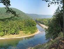
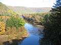 Loyalsock Creek from PA Route 87
Notable people
- Kyle Datres, college baseball player
- Pat Daneker, former MLB pitcher
- Tom Woodruff Jr., actor
See also
For histories of the other townships in Lycoming County see
References
- ↑ "2016 U.S. Gazetteer Files". United States Census Bureau. Retrieved Aug 14, 2017.
- 1 2 "Population and Housing Unit Estimates". Retrieved June 9, 2017.
- ↑ Meginness, John Franklin (1892). "Loyalsock, Hepburn, and Eldred". History of Lycoming County, Pennsylvania: including its aboriginal history; the colonial and revolutionary periods; early settlement and subsequent growth; organization and civil administration; the legal and medical professions; internal improvement; past and present history of Williamsport; manufacturing and lumber interests; religious, educational, and social development; geology and agriculture; military record; sketches of boroughs, townships, and villages; portraits and biographies of pioneers and representative citizens, etc. etc (1st ed.). Chicago: Brown, Runk & Co. ISBN 0-7884-0428-8. Retrieved 2007-04-25.
(Note: ISBN refers to Heritage Books July 1996 reprint. URL is to a scan of the 1892 version with some OCR typos).
- 1 2 Bob Hill. "Forests & Freedom: Forgotten Links In Pennsylvania's Underground Railroad". The Resource a publication of the Pennsylvania Department of Conservation and Natural Resources. Retrieved 2007-06-27.
- 1 2 Lou Hunsinger Jr. "Daniel Hughes: Giant of Freedom Road". Williamsport Sun-Gazette. Archived from the original on 2012-04-20. Retrieved 2012-02-15.
- ↑ "2007 General Highway Map Lycoming County Pennsylvania" (PDF) (Map). 1:65,000. Pennsylvania Department of Transportation, Bureau of Planning and Research, Geographic Information Division. Retrieved 2009-12-24.
- ↑ "NowData – NOAA Online Weather Data". National Oceanic and Atmospheric Administration. Retrieved 2013-07-23.
- ↑ "Station Name: PA WILLIAMSPORT". National Oceanic and Atmospheric Administration. Retrieved 2017-03-30.
- ↑ "Census of Population and Housing". Census.gov. Retrieved June 4, 2016.
- ↑ "American FactFinder". United States Census Bureau. Retrieved 2008-01-31.
| Wikimedia Commons has media related to Loyalsock Township, Lycoming County, Pennsylvania. |
Municipalities and communities of Lycoming County, Pennsylvania, United States | ||
|---|---|---|
| City | 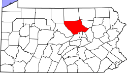 | |
| Boroughs | ||
| Townships |
| |
| CDPs | ||
| Unincorporated communities | ||
| Ghost town | ||
| Footnotes | ‡This populated place also has portions in an adjacent county | |