Cascade Township, Lycoming County, Pennsylvania
| Cascade Township, Pennsylvania | |
|---|---|
| Township | |
 | |
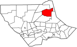 Map of Lycoming County, Pennsylvania highlighting Cascade Township | |
 Map of Lycoming County, Pennsylvania | |
| Coordinates: 41°28′0″N 76°52′19″W / 41.46667°N 76.87194°WCoordinates: 41°28′0″N 76°52′19″W / 41.46667°N 76.87194°W | |
| Country | United States |
| State | Pennsylvania |
| County | Lycoming |
| Formed | 1843 |
| Area[1] | |
| • Total | 39.53 sq mi (102.37 km2) |
| • Land | 39.20 sq mi (101.54 km2) |
| • Water | 0.32 sq mi (0.83 km2) |
| Elevation | 1,352 ft (412 m) |
| Population (2010) | |
| • Total | 413 |
| • Estimate (2016)[2] | 406 |
| • Density | 10.36/sq mi (4.00/km2) |
| Time zone | UTC-5 (Eastern Time Zone (North America)) |
| • Summer (DST) | UTC-4 (EDT) |
| ZIP code | 17771 |
| Area code(s) | 570 |
| FIPS code | 42-081-11560 |
| GNIS feature ID | 1216743[3] |
Cascade Township is a township in Lycoming County, Pennsylvania, United States. The population was 419 at the 2000 census. It is part of the Williamsport, Pennsylvania Metropolitan Statistical Area.
History
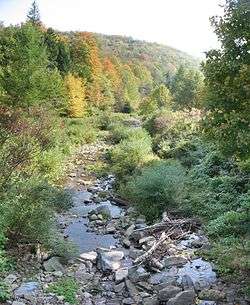
Cascade Township was formed from parts of Hepburn and Plunketts Creek townships on August 9, 1843. It is named for the series of waterfalls or cascades that are abundant in the many mountain streams of Cascade Township.
Many of the early settlers in Cascade Township were Irish Catholics. Under the leadership of Michael Kelly they established the village of Kellyburg in one of the most remote parts of Lycoming County. Michael Kelly also cut a road deep into Cascade Township from a sawmill along Lycoming Creek, and he built a gristmill and a sawmill in the township. Kelly left the area in 1877 following a bitter defeat in the sheriff election of 1872, moving to Kansas and residing there until his 1883 death. Michael Kelly also helped his fellow Catholics establish the mission parish of St. Mary's.[4]
Geography
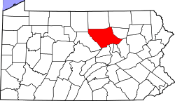
Cascade Township is bordered by McIntyre Township to the north, McNett Township to the north and east, Plunketts Creek Township to the east, Gamble Township to the south, and Lewis Township to the west.[5] As the crow flies, Lycoming County is about 130 miles (209 km) northwest of Philadelphia and 165 miles (266 km) east-northeast of Pittsburgh.
According to the United States Census Bureau, the township has a total area of 40.9 square miles (106 km2), all of it land.
Demographics
| Historical population | |||
|---|---|---|---|
| Census | Pop. | %± | |
| 2010 | 413 | — | |
| Est. 2016 | 406 | [2] | −1.7% |
| U.S. Decennial Census[6] | |||
As of the census[7] of 2000, there were 419 people, 172 households, and 130 families residing in the township. The population density was 10.2 people per square mile (4.0/km2). There were 245 housing units at an average density of 6.0/sq mi (2.3/km2). The racial makeup of the township was 98.81% White, 0.72% Native American and 0.48% Asian. Hispanic or Latino of any race were 0.72% of the population.
There were 172 households, out of which 25.0% had children under the age of 18 living with them, 66.3% were married couples living together, 6.4% had a female householder with no husband present, and 24.4% were non-families. 18.6% of all households were made up of individuals, and 7.0% had someone living alone who was 65 years of age or older. The average household size was 2.44 and the average family size was 2.78.
In the township the population was spread out, with 21.5% under the age of 18, 4.5% from 18 to 24, 29.4% from 25 to 44, 26.3% from 45 to 64, and 18.4% who were 65 years of age or older. The median age was 43 years. For every 100 females, there were 106.4 males. For every 100 females age 18 and over, there were 101.8 males.
The median income for a household in the township was $39,896, and the median income for a family was $45,208. Males had a median income of $31,000 versus $22,813 for females. The per capita income for the township was $19,465. About 5.1% of families and 8.6% of the population were below the poverty line, including 4.5% of those under age 18 and 15.5% of those age 65 or over.
References
- ↑ "2016 U.S. Gazetteer Files". United States Census Bureau. Retrieved Aug 14, 2017.
- 1 2 "Population and Housing Unit Estimates". Retrieved June 9, 2017.
- ↑ "US Board on Geographic Names". United States Geological Survey. 2007-10-25. Retrieved 2008-01-31.
- ↑ Meginness, John Franklin (1892). "Plunkett's Creek, Lewis, Cascade, and Gamble". History of Lycoming County, Pennsylvania: including its aboriginal history; the colonial and revolutionary periods; early settlement and subsequent growth; organization and civil administration; the legal and medical professions; internal improvement; past and present history of Williamsport; manufacturing and lumber interests; religious, educational, and social development; geology and agriculture; military record; sketches of boroughs, townships, and villages; portraits and biographies of pioneers and representative citizens, etc. etc (1st ed.). Chicago: Brown, Runk & Co. ISBN 0-7884-0428-8. Retrieved 2007-04-10.
(Note: ISBN refers to Heritage Books July 1996 reprint. URL is to a scan of the 1892 version with some OCR typos).
- ↑ "2007 General Highway Map Lycoming County Pennsylvania" (PDF) (Map). 1:65,000. Pennsylvania Department of Transportation, Bureau of Planning and Research, Geographic Information Division. Retrieved 2009-12-24.
- ↑ "Census of Population and Housing". Census.gov. Retrieved June 4, 2016.
- ↑ "American FactFinder". United States Census Bureau. Archived from the original on 2013-09-11. Retrieved 2008-01-31.
Municipalities and communities of Lycoming County, Pennsylvania, United States | ||
|---|---|---|
| City | | |
| Boroughs | ||
| Townships |
| |
| CDPs | ||
| Unincorporated communities | ||
| Ghost town | ||
| Footnotes | ‡This populated place also has portions in an adjacent county | |