Los Arrieros, Texas
| Los Arrieros, Texas | |
|---|---|
| Unincorporated community | |
 Los Arrieros, Texas  Los Arrieros, Texas | |
| Coordinates: 26°30′57″N 99°05′04″W / 26.51583°N 99.08444°WCoordinates: 26°30′57″N 99°05′04″W / 26.51583°N 99.08444°W | |
| Country | United States |
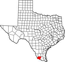
| State | Texas |
| County | Starr |
| Area[1] | |
| • Total | 0.034 sq mi (0.09 km2) |
| • Land | 0.034 sq mi (0.09 km2) |
| • Water | 0 sq mi (0 km2) |
| Elevation | 302 ft (92 m) |
| Population (2010)[1] | |
| • Total | 91 |
| • Density | 2,700/sq mi (1,000/km2) |
| Time zone | UTC-6 (Central (CST)) |
| • Summer (DST) | UTC-5 (CDT) |
| Area code(s) | 956 |
| GNIS feature ID | 2584680[2] |
Los Arrieros is an unincorporated community and census-designated place in Starr County, Texas, United States. Its population was 91 as of the 2010 census.[1] U.S. Route 83 passes through the community.
Geography
According to the U.S. Census Bureau, the community has an area of 0.034 square miles (0.088 km2), all of it land.[1]
References
This article is issued from
Wikipedia.
The text is licensed under Creative Commons - Attribution - Sharealike.
Additional terms may apply for the media files.