Indio, Texas
| Indio, Texas | |
|---|---|
| CDP | |
| Coordinates: 26°32′56″N 99°5′45″W / 26.54889°N 99.09583°W | |
| Country | United States |
| State | Texas |
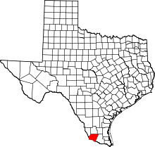
| County | Starr |
| Area | |
| • Total | 0.3 sq mi (0.8 km2) |
| • Land | 0.3 sq mi (0.8 km2) |
| • Water | 0.0 sq mi (0 km2) |
| Population (2010) | |
| • Total | 50 |
| • Density | 170/sq mi (64/km2) |
| Time zone | UTC-6 (Central (CST)) |
| • Summer (DST) | UTC-5 (CDT) |
| Zip Code | 78545, 78584 |
Indio is a census-designated place (CDP) in Starr County, Texas, United States. It is a new CDP formed from part of the Falcon Heights CDP prior to the 2010 census with a population of 50.[1]
Geography
Indio is located at 26°32′56″N 99°5′45″W / 26.54889°N 99.09583°W (26.548877, -99.095866[2]).
References
This article is issued from
Wikipedia.
The text is licensed under Creative Commons - Attribution - Sharealike.
Additional terms may apply for the media files.