Loring, Alaska
| Loring, Alaska, Naha Bay | |
|---|---|
| Census-designated place | |
 Loring Location of Loring, Alaska | |
| Coordinates: 55°36′11″N 131°38′13″W / 55.60306°N 131.63694°W | |
| Country | United States |
| State | Alaska |
| Borough | Ketchikan Gateway |
| Government | |
| • Borough mayor | David Landis[1] |
| • State senator | Bert Stedman (R) |
| • State rep. | Dan Ortiz (I) |
| Area | |
| • Total | 0.6 sq mi (1.6 km2) |
| • Land | 0.5 sq mi (1.4 km2) |
| • Water | 0.08 sq mi (0.2 km2) |
| Population (2010) | |
| • Total | 4 - 30 varies with the season |
| • Density | 7/sq mi (2.8/km2) |
| FIPS code | 02-45020 |
Loring was established in 1885 with the first post office in the District of Alaska and is a census-designated place (CDP) in Ketchikan Gateway Borough in the U.S. state of Alaska. The population was 4 at the 2010 census.Though this varies with the season when the population is around 50 in the summer months. [2]
Located due north of downtown Ketchikan on Revillagigedo Island, Loring was once Ketchikan's rival as the service center for the area's fishing and timber industries.
The official website for the community is www.loringalaska.info created in 2000 to share history, community and area information.
Geography
.jpg)
Loring is located at 55°36′11″N 131°38′13″W / 55.60306°N 131.63694°W, on the western shore of Revillagigedo Island, approximately 15 miles (24 km) north of Ketchikan as the crow flies. It is located on the northern shore of Naha Bay, an arm of Behm Canal.
According to the United States Census Bureau, the CDP has a total area of 0.62 square miles (1.6 km2), of which 0.54 square miles (1.4 km2) is land and 0.077 square miles (0.2 km2), or 12.27%, is water.[2]
Demographics
| Historical population | |||
|---|---|---|---|
| Census | Pop. | %± | |
| 1890 | 200 | — | |
| 1900 | 168 | −16.0% | |
| 2010 | 4 | — | |
| U.S. Decennial Census[3] | |||
Loring first appeared on the 1890 U.S. Census as an unincorporated fishing village and cannery.[4] It consisted of 200 residents, of which a majority (120) were native (presumably Tlingit), 51 were Asian (Chinese), 27 were White, and 2 were Creole (Mixed Native & Russian).[5] This population figure also included adjacent native fishing camps. It returned in 1900 with 168 residents, but the census did not provide a racial breakdown. Although the cannery and post office at Loring continued to operate until 1930 and 1936, respectively, it did not report on the census again from after 1900 until 110 years later, in 2010. It was made a census-designated place (CDP), with just 4 residents (2 of 2 or more races, 1 Native American & 1 White resident).[6]
References
- ↑ 2015 Alaska Municipal Officials Directory. Juneau: Alaska Municipal League. 2015. p. 10.
- 1 2 "Geographic Identifiers: 2010 Demographic Profile Data (G001): Loring CDP, Alaska". U.S. Census Bureau, American Factfinder. Retrieved March 26, 2013.
- ↑ "U.S. Decennial Census". Census.gov. Retrieved June 6, 2013.
- ↑ https://books.google.com/books?id=Rr9RAQAAMAAJ&pg=PA49&lpg=PA49&dq=%22Agaligamute%22&source=bl&ots=Tzy-F6Dup7&sig=B81GmrTlcKv3jtL_iWMYTwV3FSo&hl=en&sa=X&ved=0ahUKEwj69sDB-MLUAhXD2T4KHTt1Dc0Q6AEILjAD#v=onepage&q=loring&f=false
- ↑ https://books.google.com/books?id=CRcwAAAAYAAJ&pg=RA2-PA164&lpg=RA2-PA164&dq=%22Annovokhamiut%22&source=bl&ots=3jqomx9q3R&sig=TsX_fqmmkfgJwWTn-gBdhSHbcJU&hl=en&sa=X&ved=0ahUKEwiQ35-3gNDUAhXmx4MKHXCqCBoQ6AEILzAF#v=onepage&q&f=false
- ↑ https://www.census.gov/prod/cen2010/cph-1-3.pdf
Municipalities and communities of Ketchikan Gateway Borough, Alaska, United States | ||
|---|---|---|
| Cities | 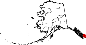 | |
| CDPs | ||
| Unincorporated community | ||
| Ghost towns | ||
Hyder is an exclave of the Ketchikan Gateway Borough and is located in the Prince of Wales–Hyder Census Area. | ||