Locust Hill, Kentucky
| Locust Hill, Kentucky | |
|---|---|
| Unincorporated community | |
 Locust Hill  Locust Hill | |
| Coordinates: 37°43′40″N 86°21′24″W / 37.72778°N 86.35667°WCoordinates: 37°43′40″N 86°21′24″W / 37.72778°N 86.35667°W | |
| Country | United States |
| State | Kentucky |
| County | Breckinridge |
| Elevation | 614 ft (187 m) |
| Time zone | UTC-6 (Central (CST)) |
| • Summer (DST) | UTC-5 (CDT) |
| Area code(s) | 270 |
| GNIS feature ID | 508488[1] |
Locust Hill is an unincorporated community in Breckinridge County, Kentucky, United States. Locust Hill is located at the junction of Kentucky Route 1073 and Kentucky Route 1401, 6.7 miles (10.8 km) east-southeast of Hardinsburg.[2] Locust Hill had a post office from June 4, 1909 to February 22, 1985.[3][4]
Its name came from a nearby hill that was covered with locust trees.
References
- ↑ "Locust Hill". Geographic Names Information System. United States Geological Survey.
- ↑ State Primary Road System: Breckinridge County (PDF) (Map). Kentucky Transportation Cabinet. 2012. Retrieved January 5, 2013.
- ↑ United States Postal Service (2012). "USPS - Look Up a ZIP Code". Retrieved 2012-02-15.
- ↑ "Postmaster Finder - Post Offices by ZIP Code". United States Postal Service. Retrieved January 5, 2013.
Municipalities and communities of Breckinridge County, Kentucky, United States | ||
|---|---|---|
| Cities | 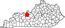 | |
| Unincorporated communities | ||
| Footnotes | ‡This populated place also has portions in an adjacent county or counties | |
This article is issued from
Wikipedia.
The text is licensed under Creative Commons - Attribution - Sharealike.
Additional terms may apply for the media files.