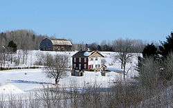
Lochaber-Partie-Ouest, Quebec
| Lochaber-Partie-Ouest | |
|---|---|
| Township municipality | |
 | |
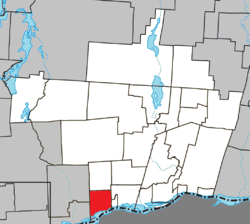 Location within Papineau RCM. | |
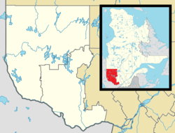 Lochaber-Partie-Ouest Location in western Quebec. | |
| Coordinates: 45°37′N 75°18′W / 45.617°N 75.300°WCoordinates: 45°37′N 75°18′W / 45.617°N 75.300°W[1] | |
| Country |
|
| Province |
|
| Region | Outaouais |
| RCM | Papineau |
| Constituted | April 20, 1891 |
| Government[2] | |
| • Mayor | Michel Labrecque |
| • Federal riding | Argenteuil—Papineau—Mirabel |
| • Prov. riding | Papineau |
| Area[2][3] | |
| • Total | 66.00 km2 (25.48 sq mi) |
| • Land | 57.41 km2 (22.17 sq mi) |
| Population (2011)[3] | |
| • Total | 646 |
| • Density | 11.3/km2 (29/sq mi) |
| • Pop 2006-2011 |
|
| • Dwellings | 248 |
| Time zone | UTC−5 (EST) |
| • Summer (DST) | UTC−4 (EDT) |
| Postal code(s) | J0X 3B0 |
| Area code(s) | 819 |
| Highways |
|
Lochaber-Partie-Ouest is a township municipality in the Canadian province of Quebec, located within the Papineau Regional County Municipality. The township had a population of 646 in the Canada 2011 Census.
References
Places adjacent to Lochaber-Partie-Ouest, Quebec | ||||||||||
|---|---|---|---|---|---|---|---|---|---|---|
| ||||||||||
| Cities | |
|---|---|
| Municipalities | |
| Townships | |
| |
This article is issued from
Wikipedia.
The text is licensed under Creative Commons - Attribution - Sharealike.
Additional terms may apply for the media files.