Little Rock to Cantonment Gibson Road-Old Wire Road Segment
|
Little Rock to Cantonment Gibson Road--Old Wire Road Segment | |
 | |
  | |
| Nearest city | Blackwell, Arkansas |
|---|---|
| Coordinates | 35°12′47″N 92°50′45″W / 35.21306°N 92.84583°WCoordinates: 35°12′47″N 92°50′45″W / 35.21306°N 92.84583°W |
| Area | less than one acre |
| MPS | Cherokee Trail of Tears MPS |
| NRHP reference # | 07001465[1] |
| Added to NRHP | March 27, 2008 |
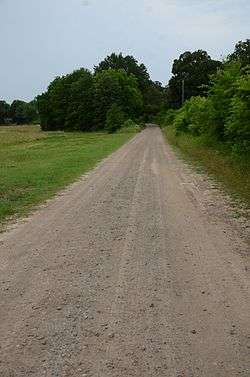
The Little Rock to Cantonment Gibson Road-Old Wire Road Segment is a historic road section in Conway County, Arkansas. It consists of a section of Old Wire Road, southwest of the hamlet of Blackwell, which is about 300 metres (980 ft) long and 18 feet (5.5 m) wide. It is defined in part by the cut through which it passes, with steep banks on either side. Built in 1827, it is one of the oldest surviving road alignments of the military road built between Little Rock, and what is now Fort Gibson in Oklahoma. This route formed part of the Trail of Tears, the historic removal of Native Americans to the Indian Territory that is now Oklahoma.[2]
The road section was listed on the National Register of Historic Places in 2008.[1]
See also
References
- 1 2 National Park Service (2010-07-09). "National Register Information System". National Register of Historic Places. National Park Service.
- ↑ "NRHP nomination for Little Rock to Cantonment Gibson Road-Old Wire Road Segment" (PDF). Arkansas Preservation. Retrieved 2016-04-06.
| Topics | |
|---|---|
| Lists by states |
|
| Lists by insular areas | |
| Lists by associated states | |
| Other areas | |
| |
This article is issued from
Wikipedia.
The text is licensed under Creative Commons - Attribution - Sharealike.
Additional terms may apply for the media files.