List of scheduled monuments in South Somerset
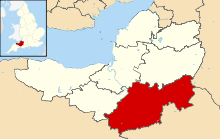
South Somerset is a local government district in Somerset, England. The South Somerset district covers an area of 370 square miles (958 km2)[1] ranging from the borders with Devon and Dorset to the edge of the Somerset Levels. It has a population of approximately 162,000.[2] The administrative centre of the district is Yeovil.
A scheduled monument is a nationally important archaeological site or monument which is given legal protection by being placed on a list (or "schedule") by the Secretary of State for Culture, Media and Sport; Historic England takes the leading role in identifying such sites. The legislation governing this is the Ancient Monuments and Archaeological Areas Act 1979. The term "monument" can apply to the whole range of archaeological sites, and they are not always visible above ground. Such sites have to have been deliberately constructed by human activity. They range from prehistoric standing stones and burial sites, through Roman remains and medieval structures such as castles and monasteries, to later structures such as industrial sites and buildings constructed for the World Wars or the Cold War.[3]
There are 69 scheduled monuments in South Somerset.[4][5] Some of the oldest are Neolithic, Bronze Age or Iron Age including hillforts, such as Kenwalch's Castle and Bowl barrows. The Romano-British period is represented with several sites including the Low Ham Roman Villa which included an extensive mosaic floor, now on display in the Museum of Somerset.[6] Religious sites are represented by Muchelney Abbey, which was probably founded in the 8th century,[7] and Montacute Priory, a Cluniac priory of the Benedictine order, from the 11th.[8] Bruton Abbey was founded by the Benedictines before becoming a house of Augustinian canons. Stoke sub Hamdon Priory was formed in 1304 as a chantry college rather than a priory.[9] More recent sites include several motte-and-bailey castles such as Cary Castle,[10] and church crosses which date from the Middle Ages. Several packhorse bridges, such as Bow Bridge, Plox also appear in the list. The most recent monuments include the Round House, a village lock-up in Castle Cary dating from 1779, and several duck decoys[11][12][13] The monuments are listed below using the titles given in the English Heritage data sheets.
Monuments
| Name | Location | Type | Completed [note 1] | Grid ref.[note 2] Geo-coordinates | Notes | Entry number [note 3] | Image | Ref. |
|---|---|---|---|---|---|---|---|---|
| A motte with two baileys immediately north of Park Pond | Castle Cary | Motte-and-bailey castle | Middle Ages | ST 64169 32192 51°05′18″N 2°30′48″W / 51.0884°N 2.5132°W |
Cary Castle was built either by Walter of Douai or by his son Robert in the late 11th or early 12th century. In 1143, after the Battle of Wilton, Henry de Tracy gained control of Cary Castle and built another stronghold in front of the older castle; however this was demolished when William Fitz Robert, 2nd Earl of Gloucester and his troops arrived to take the castle. By 1468 the castle had been abandoned. Around that time a manor house was built on or adjacent to the site of the castle, possibly by Baron Zouche. It later passed to Edward Seymour, 1st Duke of Somerset but by the 1630s it was occupied by Edward Kirton. It was largely demolished at the end of the 18th century. | 1019897 | 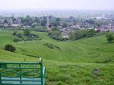 | [14][15] [16][17] |
| Augustinian priory, later abbey and associated pillow mound, at King's School | Bruton | Priory | 12th century | ST 68464 34709 51°06′40″N 2°27′07″W / 51.111°N 2.452°W |
Bruton Abbey was founded as a house of Augustinian canons in 1135, by William de Mohun, who later became the Earl of Somerset. It may have been a Benedictine priory before the Norman conquest of England. After the Dissolution of the Monasteries the abbey was granted to a John Drew of Bristol, but later transferred to Sir Maurice Berkeley. The latter built a house on the site incorporating some of the buildings, but this was demolished in 1786. | 1020015 | 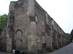 | [18] |
| Ballands Castle | Penselwood | Motte-and-bailey castle | Middle Ages | ST 75360 31017 51°04′42″N 2°21′12″W / 51.0782°N 2.3533°W |
Ballands Castle was a motte-and-bailey castle, probably built after the Norman conquest of England in 1066. The castle sits close to the contemporary Norman castles of Cockroad Wood and Castle Orchard, and may have been built as part of a system of fortifications to control the surrounding area.The motte of the castle is now around 5 metres (16 ft) high, and up to 9 metres (30 ft) wide. The bailey lies to the south, and both the motte and the bailey are surrounded by ditches. | 1014713 |  | [19][20] |
| Barn W of Muchelney Abbey | Muchelney | Tithe barn | 16th century | ST 42783 24914 51°01′15″N 2°49′02″W / 51.0207°N 2.8171°W |
The tithe barn of Muchelney Abbey was used to store produce from the farms belonging to the abbey. | 1006181 | | [21] |
| Bineham City deserted village | Long Sutton | Earthworks | Middle Ages | ST 50001 24886 51°01′16″N 2°42′51″W / 51.0212°N 2.7142°W |
The remains of a medieval village occupied from the 13th to 17th centuries. Masonry foundations of rectangular buildings have been identified. | 1006142 | | [22][23] |
| Bowl barrow 110 m south west of Spittle Pond Cottages | Wambrook | Bowl barrow | Bronze Age | ST 29402 08882 50°52′30″N 3°00′17″W / 50.8751°N 3.0048°W |
A bowl barrow mound which is 24 metres (79 ft) in diameter and 0.7 metres (2 ft 4 in) high. | 1020545 | | [24] |
| Bowl barrow known as 'Wimble Toot' | Babcary | Bowl barrow or Motte-and-bailey castle | Bronze Age or Norman | ST 56048 28003 51°02′59″N 2°37′42″W / 51.0497°N 2.6284°W |
Wimble Toot is a circular earthwork, 27.4 metres (90 ft) across and 2.7 metres (8 ft 10 in) high, with a ditch on the north-west and south-east sides, on the top of a ridge, overlooking a brook which runs into the River Cary and the old Roman road of the Fosse Way. Generally the site is classified as a Bronze Age barrow, used for the burial of the dead, or a windmill mound. An alternative interpretation is that the site was a motte, built after the Norman conquest of England. | 1015279 |  | [25][26] |
| Bowl barrow on Charn Hill | Charlton Horethorne | Bowl barrow | Neolithic to Bronze Age | ST 66710 23488 51°00′35″N 2°28′33″W / 51.0098°N 2.4759°W |
A bowl barrow approximately 16 metres (52 ft) in diameter and 3 metres (9.8 ft) high. | 1014711 | | [27] |
| Chessels Roman villa | East Coker | Roman villa | Romano-British | ST 52874 13831 50°55′19″N 2°40′18″W / 50.9220°N 2.6718°W |
In 1861 the site was uncovered and tesserae, tiles, slates and painted wall plaster were uncovered from a villa which may have burnt down. | 1006186 | | [28][29] |
| Combe Beacon barrow | Combe St Nicholas | Bell barrow | Bronze Age | ST 29481 12279 50°54′21″N 3°00′15″W / 50.9057°N 3.0043°W |
A bell barrow approximately 38 metres (125 ft) in diameter and 4 metres (13 ft) high. It was used as the site for a beacon in the 18th century. | 1018633 | | [30] |
| Compton Dundon hillfort with Dundon Beacon, east of Dundon | Compton Dundon | Hillfort | Iron Age | ST 48452 32209 51°05′13″N 2°44′13″W / 51.0869°N 2.7369°W |
Dundon Hill Hillfort is an Iron Age hillfort. South east of the site is a Bronze Age bowl barrow which, it has been suggested, was later modified as a Norman Motte, known as Dundon Beacon. The 5-hectare (12-acre) site is guarded by a single bank ranging from 0.5 to 2.5 metres (1.6 to 8.2 ft) high, however parts of the site have been damaged by quarrying. Flint flakes, Bronze Age pottery, and Iron Age pottery have also been found, which are now in the Museum of Somerset. | 1014715 | 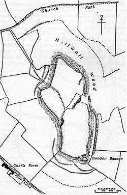 | [31][32] |
| Cross in St Aldhelm and St Eadburga churchyard | Broadway | Cross | 13th century | ST 32959 15893 50°56′19″N 2°57′20″W / 50.9386°N 2.9555°W |
The base of the cross has two steps. The shaft has two carved figures. | 1017250 | | [33] |
| Cross in St Catherine's churchyard | Drayton | Cross | 15th century | ST 40527 24762 51°01′09″N 2°50′57″W / 51.0191°N 2.8493°W |
The octagonal base of the cross has three steps. The shaft of the cross is topped by a stone ball finial which are more recent than the base. | 1018637 | 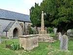 | [34] |
| Cross in the churchyard of St John the Baptist 15 m south east of the church door | Brewham | Cross | Middle Ages | ST 71977 36126 51°07′25″N 2°24′06″W / 51.1237°N 2.4018°W |
The cross has a rectangular base supporting an octagonal shaft from which the head is missing. | 1018924 | .jpg) | [35] |
| Deserted medieval settlement and associated fields, Lytes Cary | Lytes Cary | Earthworks | Middle Ages | ST 53126 26545 51°02′11″N 2°40′12″W / 51.0363°N 2.6699°W |
Earthworks within the grounds of Lytes Cary date from the medieval period. They now consist of low grassy banks. | 1008253 | | [36][37] |
| Deserted medieval village of Nether Adber | Marston Magna | Earthworks | Middle Ages | ST 58815 21265 50°59′21″N 2°35′18″W / 50.9893°N 2.5882°W |
earthworks show the remains of several buildings gathered around a village green. At least one house was still occupied in the 16th century. | 1008251 |  | [38][39] |
| Duck decoy on Middle Moor | Aller | Duck decoy | 17th century | ST 40136 28150 51°02′59″N 2°51′19″W / 51.0496°N 2.8554°W |
The remains of a six-pipe duck decoy constructed in 1676 and unused by the late 19th century. | 1014451 | | [40] |
| Duck decoy 700 m WNW of Rookery Farm | Kingsdon | Duck decoy | 18th or 19th century | ST 51865 28412 51°03′11″N 2°41′17″W / 51.0530°N 2.6881°W |
The remains of a duck decoy close to the River Cary. It is now a small pond with an island. | 1015206 | | [41] |
| Early Medieval and Medieval urban remains, Milborne Port | Milborne Port | Earthworks | Middle Ages | ST 67710 18572 50°57′57″N 2°27′40″W / 50.9657°N 2.4612°W |
Dispersed remains of the early market town including post holes of buildings near Church Street. | 1017393 | | [42][43] |
| Hamdon Hill camp | Stoke-sub-Hamdon | Hillfort | Iron Age | ST 48296 16427 50°57′05″N 2°44′38″W / 50.9514°N 2.7439°W |
Ham Hill Hillfort is an Iron Age hillfort located on Ham Hill. It covers an area of 210 acres (85 ha), making it one of the largest hillforts in Britain. The site was also occupied during the mesolithic and neolithic periods and later during Roman and medieval eras. | 1003678 | 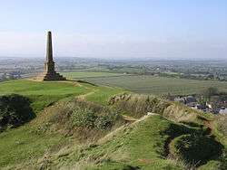 | [44][45][46] |
| Haselbury Bridge | Haselbury Plucknett | Bridge | 14th century | ST 45851 10969 50°53′44″N 2°46′17″W / 50.8956°N 2.7713°W |
A 14th-century stone bridge carrying a minor road over the River Parrett. The bridge is 4 metres (13 ft) wide and has two pointed arches. | 1020497 | | [47][48] |
| Hillfort 475 m south of Howley Farm | Whitestaunton | Hillfort | Iron Age | ST 26505 08939 50°52′35″N 3°02′43″W / 50.8763°N 3.0453°W |
Horse Pool Camp is a univallate Iron Age hillfort enclosure also known as Whitestaunton Camp. The hillfort is an oval shape that is 300 metres (980 ft) long and 150 metres (490 ft) wide. | 1018636 | | [49][50] |
| Hillfort 550 yd (501 m) SE of Four Gates | Wambrook | Hillfort | Iron Age | ST 31092 07457 50°51′45″N 2°58′50″W / 50.8625°N 2.9805°W |
The earthworks of a univallate hillfort. The site is 324 by 148 metres (1,063 by 486 ft), surrounded by a bank and outer ditch. | 1006146 | | [51][52] |
| Ilchester Roman town | Ilchester | Earthworks | Romano-British | ST 52042 22873 51°00′04″N 2°40′55″W / 51.001°N 2.682°W |
Lindinis was a small town in the Roman province of Britannia. A timber walled fort was established there around AD 60 and later a second fort seems to have been built. Originally surrounded by native round houses, these were later supplanted by a vicus or unplanned civil area of around 30 acres (120,000 m2). | 1006155 | | [53][54] [53][55] |
| Kenwalch's Castle: a large univallate hillfort on Pen Hill | Charlton Musgrove | Hillfort | Iron Age | ST 74777 33536 51°06′02″N 2°21′42″W / 51.1006°N 2.3617°W |
Kenwalch's Castle is probably an Iron Age hillfort that may have been converted into a Roman fortress. It covers an area of 1.6 hectares (4.0 acres). There is a single rampart and ditch which are well preserved in places. The road north from Penselwood village crosses the hillfort and probably passes through the original entrances. | 1008257 | 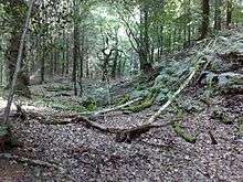 | [56][57] |
| Later Iron Age enclosure, Ilchester Mead | Ilchester | Earthworks | Iron Age | ST 52011 22044 50°59′45″N 2°41′07″W / 50.9958°N 2.6852°W |
The remains of an earth rampart and ditch system. | 1006129 | | [58][59] |
| Low Ham Roman Villa | Low Ham | Roman villa | Romano-British | ST 43649 28874 51°03′36″N 2°48′39″W / 51.06°N 2.8108°W |
The villa appears to have been constructed around AD 340. Aerial photography has shown that there are a number of farm buildings around a large courtyard, although the excavations concentrated on the residential west wing and bath house. The large 14 foot (4.3 m) square mosaic depicts the story of Aeneas and Dido, as told in the 1st century BC by the Roman poet, Virgil. Like the villa, it dates to the mid-4th century. The Low Ham mosaic is unique in Roman Britain in providing a narrative story in five panels: Aeneas sailing to Carthage, Aeneas meeting Dido, the couple out hunting, the couple embrace and Dido left alone after Aeneas' departure. It is the earliest piece of narrative art in the country. It was lifted in 1953 and is now on display in the Museum of Somerset. The site has been placed on the Heritage at Risk register due to the risks from extensive animal burrowing. | 1006192 |  | [60][61][62] |
| Lower Woolston medieval settlement | North Cadbury | Earthworks | Middle Ages | ST 65578 27411 51°02′42″N 2°29′33″W / 51.0450°N 2.4924°W |
Earthworks show the site of houses and water management features. The site is mentioned in documents from the 14th century. | 1018150 | | [63] |
| Maperton medieval settlement | Maperton | Earthworks | Middle Ages | ST 67461 26354 51°02′08″N 2°27′55″W / 51.0356°N 2.4654°W |
Earthworks show the site of a village, with a village pond, and ridge and furrow agriculture. | 1018151 | | [64] |
| Marston Magna moated site and associated earthworks | Marston Magna | Earthworks | Middle Ages | ST 59489 22189 50°59′52″N 2°34′43″W / 50.9977°N 2.5787°W |
Earthworks show the site of a moated building, ridge and furrow agriculture and a fishpond. | 1008250 | 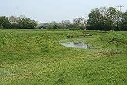 | [38][65] |
| Medieval bridge 100 m south west of Wyke House | Wyke Champflower | Bridge | 15th century | ST 65706 34046 51°06′17″N 2°29′28″W / 51.1047°N 2.4912°W |
A 15th-century stone bridge over the River Brue. The bridge, which is 13 metres (43 ft) long, has two arches. | 1020496 | | [66] |
| Medieval secular college at Parsonage Farm | Stoke-sub-Hamdon | Priory | 14th century | ST 47324 17440 50°57′16″N 2°44′56″W / 50.9545°N 2.7488°W |
Stoke sub Hamdon Priory is a complex of buildings and ruins initially built in the 14th century for priests serving the chantry chapel of St Nicholas. During the 14th and early 15th centuries, the college fell into disrepair and was rebuilt around 1460. The only building remaining from the religious use is a great hall and attached dwelling, dating from the late 15th century. During the dissolution, the land passed into the laity, and was a tenanted farm until the middle of the 20th century. | 1020665 | 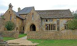 | [9][67][68] |
| Medieval settlement 190 m south west of Perry's Bridge | Babcary | Earthworks | Middle Ages | ST 57563 30182 51°04′10″N 2°36′25″W / 51.0694°N 2.6070°W |
Earthworks show the site of houses, tracks and ponds. | 1019031 | | [69] |
| Medieval settlement 300 m east of Knight House Farm | Cudworth | Earthworks | Middle Ages | ST 37536 10619 50°53′30″N 2°53′22″W / 50.8917°N 2.8895°W |
Earthworks show the site of houses, tracks and farming. | 1016412 | | [70] |
| Medieval settlement remains 100 m and 250 m north of Downhead Manor Farm | West Camel | Earthworks | Middle Ages | ST 56624 25590 51°01′41″N 2°37′12″W / 51.0280°N 2.6199°W |
Earthworks show the site of houses, possibly including a manor house, tracks and a fish pond. The settlement existed before the Norman conquest and was abandoned by the late 18th century. | 1021260 | | [71] |
| Melbury Roman villa | Somerton | Roman villa | Romano-British | ST 47932 27514 51°02′41″N 2°44′39″W / 51.0446°N 2.7441°W |
The site of a Roman villa with hypocaust tiles. Various artefacts have been uncovered at the site. | 1002954 | | [72][73] |
| Moated site 800 m NNW of Pipplepen Farmhouse | North Perrott | Earthworks | Middle Ages | ST 47172 08399 50°52′22″N 2°45′08″W / 50.87266°N 2.7522°W |
Earthworks of a 80-by-75-metre (262 by 246 ft) platform with the remains of buildings. The site with its surrounding moat is believed to be the medieval mansion home of the De Pipplepens. | 1018923 | | [74] |
| Moated site, two fishponds and associated earthworks at Knight House Farm | Cudworth | Earthworks | Middle Ages | ST 37279 10784 50°53′35″N 2°53′36″W / 50.8931°N 2.8932°W |
Earthworks of a 50-metre (160 ft) platform with the remains of buildings. The site with its surrounding moat is believed to be the medieval mansion home of Matthew de Esse. | 1018635 | 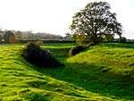 | [75] |
| Montacute Castle a motte and bailey castle on St Michael's Hill | Montacute | Motte-and-bailey castle | 11th century | ST 49355 16966 50°56′59″N 2°43′20″W / 50.9497°N 2.7223°W |
Montacute Castle was built after the Norman conquest of England in 1066 by Robert of Mortain. An 18th-century folly, St. Michael's Hill Tower, named after the castle chapel, stands on the site today, making use of part of the castle chapel's foundations. The site is owned by the National Trust and is open to the public. | 1008466 | 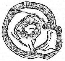 | [76][77][78] |
| Motte-and-bailey castle in Cockroad Wood | Charlton Musgrove | Motte-and-bailey castle | 11th century | ST 74618 32147 51°05′14″N 2°37′42″W / 51.0871°N 2.6283°W |
Cockroad Wood Castle was a motte-and-bailey castle, probably built after the Norman conquest of England in 1066. The castle sits close to the contemporary Norman castles of Ballands and Castle Orchard, and may have been built a system of fortifications to control the surrounding area. By 1086 the surrounding land was held by Walter of Douai, although no documentary evidence of the castle remains
The castle was built with a motte and two baileys, running along a north-south ridge, with a possible entrance to the east. The motte today is 13.5 metres (44 ft) wide, up to 7.5 metres (25 ft) high and is surrounded by a 1.25-metre (4 ft 1 in) deep ditch. The two baileys were probably linked to the motte by wooden bridges. |
1008256 | 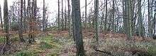 | [20][79][80] |
| Muchelney Abbey | Muchelney | Abbey | 8th century | ST 42883 24732 51°01′09″N 2°48′57″W / 51.0191°N 2.8157°W |
Muchelney Abbey is an English Heritage property. The site consists of ruined walls showing the layout of the abbey buildings constructed from the 8th to 16th and the remaining intact Abbott's House. It is next to the parish church in which some of the fabric of the abbey has been reused. It comprises the remains and foundations of a medieval Benedictine abbey, the site of an earlier Anglo-Saxon abbey, and an early Tudor house dating from the 16th century, formerly the lodgings of the resident Abbot, which is now a Grade I listed building. | 1006230 | 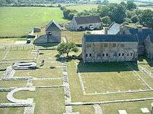 | [81][82] |
| Northover House, late Roman cemetery | Ilchester | Earthworks with stone and lead coffins | Romano-British | ST 52165 22965 51°00′15″N 2°40′59″W / 51.0041°N 2.6831°W |
Coffins made of stone and lead, dating from the late 4th century, have been found in the grounds of Northover House. A survey in the 1980s estimated here had been over 1500 burials. The site is on the Heritage at Risk register due to scrub and tree growth. | 1006128 | | [83][84] [85] |
| Pen Pits quern quarries N of Combe Bottom | Penselwood | Earthworks | Iron Age, Romano-British and Middle Ages | ST 76615 32040 51°05′14″N 2°20′07″W / 51.0872°N 2.3353°W |
A series of bowl shaped pits which were used as stone quarries during the Iron Age, Romano-British and Middle Ages. | 1004687 | | [86] |
| Pill Bridge | Ilchester | Packhorse bridge | 17th century | ST 50005 23392 51°00′28″N 2°42′50″W / 51.0077°N 2.7140°W |
A 17th-century stone packhorse bridge over the River Yeo, which replaced an earlier 13th-century bridge at the same site. | 1006214 | 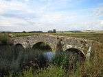 | [87][88] |
| Pottery kiln S of Whitney Bottom | Donyatt | Kiln | 14th to 17th century | ST 32332 13634 50°55′06″N 2°57′50″W / 50.9182°N 2.9640°W |
The remains of pottery kilns built in the 17th and 18th centuries. They were excavated in the 1960s and 1970s. | 1002961 | | [89][90] |
| Promontory fort on Barrow Hill | Milborne Port | Hillfort | Iron Age | ST 67116 20755 50°59′07″N 2°28′11″W / 50.9853°N 2.4698°W |
A bank and ditch system surrounding the site of an Iron Age hillfort on Barrow Hill. | 1016738 | | [42][91] |
| Prospect tower 230 m south of King's School | Bruton | Dovecote | 15th or 16th century | ST 68384 34418 51°06′30″N 2°27′11″W / 51.1082°N 2.4530°W |
Bruton Dovecote was built in the 16th century. It was at one time used as a house, possibly as a watchtower and as a dovecote. The building was once within the deerpark of Bruton Abbey and was adapted by the monks from a gabled Tudor tower. The conversion to be a dovecote took place around 1780. The square tower was built of local stone with Doulting stone dressings. Although it is now a roofless ruin and some of the windows have been blocked up, it previously had a chimney and the fireplace can still be seen. | 1019895 | 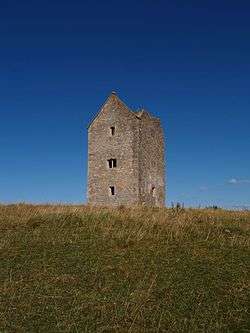 | [18][92][93] |
| Roman house S of Fair View House | Curry Rivel | Roman villa | Romano-British | ST 39681 24840 51°01′11″N 2°51′41″W / 51.0198°N 2.8613°W |
Marks have been identified within a large arable field which may represent the foundations of a Roman villa. | 1006185 | | [94] |
| Roman house W of vicarage | Drayton | Roman villa | Romano-British | ST 40072 24797 51°01′10″N 2°51′21″W / 51.0194°N 2.8558°W |
Crop marks may represent the site of a Roman building. | 1006184 | | [95] |
| Romano-British settlement immediately south west of Camel Hill Farm | Queen Camel | Earthworks | Romano-British | ST 58473 25535 51°01′40″N 2°35′37″W / 51.0277°N 2.5935°W |
The site of a Roman settlement occupied in the 2nd to 4th centuries. Stone foundations of at least three buildings have been identified. | 1020936 | | [96] |
| Roman villa at Lufton | Brympton | Roman villa | Romano-British | ST 51552 17825 50°57′28″N 2°41′28″W / 50.9578°N 2.6912°W |
The site of a Roman villa excavated after the discovery of mosaics including one depicting people dressed in Roman dress and a hunting scene. | 1006159 | | [97] |
| Roman villa N of Dunnock's Lane | East Coker | Roman villa | Romano-British | ST 54604 13755 50°55′17″N 2°38′50″W / 50.9215°N 2.6472°W |
Excavations from the 1940s to 1960s showed the remains of a Roman corridor villa with an extensive bath block. Many of the rooms had mosaic floors and walls. | 1003029 | | [98] |
| Roman villa N of Stowey Hill | Pitney | Roman villa | Romano-British | ST 45085 30080 51°04′03″N 2°47′06″W / 51.0674°N 2.7851°W |
A Roman villa excavated in the 19th century, with baths, hypocausts and mosaics. Nearby is a mausoleum which included coins from Vespasian and the Nerva–Antonine dynasty. | 1006183 | | [99] |
| Roman villa N of Whitestaunton | Whitestaunton | Roman villa | Romano-British | ST 28022 10589 50°53′25″N 3°01′29″W / 50.8903°N 3.0247°W |
Excavations in the 19th century uncovered the site of a Roman villa in the grounds of Whitestaunton Manor. Further work in 2003 by the Time Team identified a bath house. | 1006124 | | [100][101] |
| Somerton Market Cross | Somerton | Market cross | 14th century | ST 49046 28551 51°03′14″N 2°43′42″W / 51.0540°N 2.7284°W |
Market crosses have stood in the square at Somerton since before 1390; the present Butter Cross, an octagonal roofed market cross, was rebuilt in 1673. It has a slate roof supported by eight arches. | 1016740 | 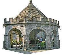 | [102][103] |
| The Round House | Castle Cary | Village lock-up | 1779 | ST 64051 32385 51°05′23″N 2°30′53″W / 51.0896°N 2.5147°W |
A small circular stone building, which served as the village lock-up. | 1016741 | 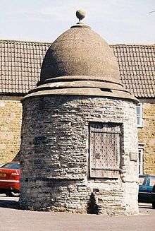 | [11][13][104] |
| Site of a Cluniac priory immediately east of Abbey Farm | Montacute | Priory | 11th century | ST 49683 16805 50°56′54″N 2°43′02″W / 50.9482°N 2.7172°W |
Montacute Priory was a Cluniac priory of the Benedictine order founded between 1078 and 1102 by William, Count of Mortain. All that remains is the Abbey Farmhouse which incorporates the gateway of Montacute Priory, although the sites of an associated fishpond and dovecote have been excavated. | 1019898 | | [8][105] [106][107] |
| The Hanging Chapel and a medieval gateway at The Hill | Langport | Chapel | Middle Ages | ST 42333 26746 51°02′11″N 2°49′30″W / 51.0364°N 2.825°W |
The Hanging Chapel (more formally known as the Chantry Chapel of the Blessed Virgin Mary) is a 13th-century archway, bearing a Perpendicular building known as the hanging chapel. Excavation in the 1990s showed that the gateway and chapel had been built on the site of a Saxon bank around the town. The archway is all that remains of the east gate of the defended town. The archway which goes over the former main road takes the form of a pointed barrel vault. | 1019290 | 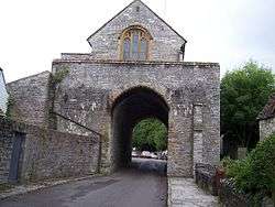 | [108][109] |
| The Packhorse Bridge 100 m north west of the Church of St Mary | Bruton | Packhorse bridge | 15th century | ST 68358 34819 51°06′43″N 2°27′18″W / 51.1119°N 2.455°W |
Bow Bridge is a 15th-century Packhorse bridge over the River Brue. The bridge may have been built as a link between the former Bruton Abbey, and its Court House in the High Street. On the parapet on the western side of the bridge the remains of a carved shield can still be seen. The bridge was restored after floods on 12 July 1982. | 1019894 | 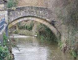 | [110][111] [112][113] |
| Two bowl barrows 300 m north west of Northay Farm | Whitestaunton | Bowl barrow | Bronze Age | ST 28098 11494 50°53′54″N 3°01′26″W / 50.8984°N 3.0238°W |
A pair of bowl barrows on the Blackdown Hills. The northernmost barrow of the pair was excavated in 1876 which revealed a pottery urn of ashes and other human remains along with a bronze dagger blade. | 1016413 | | [114][115] |
| Village cross | Horsington | Cross | Middle Ages | ST 70307 23841 51°00′48″N 2°25′29″W / 51.0132°N 2.4246°W |
A medieval hamstone cross with an octagonal shaft on a stepped circular base. | 1017016 | 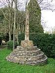 | [116] |
| Village cross | Hinton St George | Cross | Middle Ages | ST 41973 12624 50°54′37″N 2°49′36″W / 50.9102°N 2.8267°W |
is a 2.5-metre (8 ft 2 in) high cross with a tapering octagonal shaft on stepped octagonal base. | 1018634 | .jpg) | [117] |
| Wadeford Roman villa | Combe St Nicholas | Roman villa | Romano-British | ST 30881 10521 50°53′24″N 2°59′03″W / 50.8900°N 2.9841°W |
The site of a Roman villa which was excavated in the 19th century. Finds included coins from the 3rd century and wall mosaics. A Bronze Age spearhead from the site is in the Museum of Somerset. | 1006187 | | [118][119] |
| West Mudford medieval settlement, 500 m south west of West Mudford Farm | Mudford | Earthworks | Middle Ages | ST 56465 20064 50°58′42″N 2°37′17″W / 50.9783°N 2.6215°W |
Earthworks including houses and ponds from a settlement occupied in the 13th and 14th centuries. It is surrounded by a medieval field system. | 1018138 | | [120] |
See also
Notes
- ↑ The date given is the date used by Historic England as significant for the initial building or that of an important part in the structure's description.
- ↑ Sometimes known as OSGB36, the grid reference is based on the British national grid reference system used by the Ordnance Survey.
- ↑ The "List Entry Number" is a unique number assigned to each listed building and scheduled monument by Historic England.
References
- ↑ "An introduction to South Somerset" (PDF). South Somerset District Council. Retrieved 6 June 2012.
- ↑ "About Our District". South Somerset Council. Retrieved 22 November 2014.
- ↑ "Scheduled Monuments". Historic England. Retrieved 3 November 2015.
- ↑ "Scheduled Monuments". South Somerset Council. Retrieved 9 September 2014.
- ↑ "National Archeological Sites" (PDF). South Somerset Council. Retrieved 21 September 2014.
- ↑ "Museum of Somerset opens!". Victoria County History. Retrieved 9 September 2014.
- ↑ Historic England. "Muchelney Abbey (193791)". PastScape. Retrieved 15 September 2014.
- 1 2 "Montacute Priory". Somerset Historic Environment Record. Somerset County Council. Retrieved 12 July 2009.
- 1 2 Pantin, W. A. (1959). "Chantry Priests' Houses and other Medieval Lodgings" (PDF). Medieval Archaeology. Society for Medieval Archaeology. 3: 219–224. Retrieved 22 November 2014.
- ↑ Historic England. "Monument No. 200127". PastScape. Retrieved 17 July 2011.
- 1 2 Byford, Enid (1987). Somerset Curiosities. Dovecote Press. p. 16. ISBN 0946159483.
- ↑ Warren, Derrick (2005). Curious Somerset. Sutton Publishing. p. 32. ISBN 978-0-7509-4057-3.
- 1 2 Historic England. "The Round House (1056279)". National Heritage List for England. Retrieved 21 March 2014.
- ↑ Historic England. "Monument No. 200127". PastScape. Retrieved 17 July 2011.
- ↑ Richardson, Miranda. "An archaeological assessment of Castle Cary" (PDF). English Heritage Extensive Urban Survey. Somerset County Council. p. 4. Archived from the original (PDF) on 29 November 2014. Retrieved 17 July 2011.
- ↑ Adkins, Lesley and Roy (1992). A field Guide to Somerset Archeology. Stanbridge: Dovecote press. p. 35. ISBN 0-946159-94-7.
- ↑ "Castle, Castle Cary". Somerset Historic Environment Record. Somerset County Council. Retrieved 17 July 2011.
- 1 2 Historic England. "Bruton Abbey (199997)". PastScape. Retrieved 30 December 2013.
- ↑ Balland's Castle, Penselwood, Somerset County Historic Environmental Record, accessed 18 July 2011.
- 1 2 Creighton, Oliver Hamilton. (2005) Castles and Landscapes: Power, Community and Fortification in Medieval England. London: Equinox. ISBN 978-1-904768-67-8.
- ↑ "Almonry Barn, Almonry Farm, Muchelney". Somerset Historic Environment Record. Somerset County Council. Retrieved 21 September 2014.
- ↑ R. W. Dunning (editor), A. P. Baggs, R. J. E. Bush, Margaret Tomlinson (1974). "Parishes: Long Sutton". A History of the County of Somerset: Volume 3. Institute of Historical Research. Retrieved 15 November 2014.
- ↑ "Bineham deserted medieval village, Long Sutton". Somerset Historic Environment Record. Somerset County Council. Retrieved 15 November 2014.
- ↑ "Round barrow, 110 m south west of Spittle Pond Cottages, Higher Wambrook". Somerset Historic Environment Record. Somerset County Council. Retrieved 21 September 2014.
- ↑ "Wimble Toot, Babcary". Gatehouse. Retrieved 21 September 2014.
- ↑ Historic England. "Wimble Toot (196316)". PastScape. Retrieved 21 September 2014.
- ↑ Historic England. "Bowl barrow on Charn Hill (1014711)". National Heritage List for England. Retrieved 15 November 2014.
- ↑ "Roman villa, West Coker". Somerset Historic Environment Record. Somerset County Council. Retrieved 15 November 2014.
- ↑ Historic England. "Monument No. 196297". PastScape. Retrieved 15 November 2014.
- ↑ Historic England. "Combe Beacon barrow (1018633)". National Heritage List for England. Retrieved 15 November 2014.
- ↑ Historic England. "Dundon Hill (194013)". PastScape. Retrieved 2 February 2011.
- ↑ "Dundon Hillfort, Compton Dundon". Historic Environment Record. Somerset County Council. Retrieved 27 December 2010.
- ↑ Historic England. "Churchyard cross, about 5 m south of nave, Church of t Aldhelm and St Eadburha (264066)". Images of England. Retrieved 21 September 2014.
- ↑ Historic England. "Churchyard Cross in churchyard of Church of St. Catherine (264340)". Images of England. Retrieved 21 September 2014.
- ↑ Historic England. "Cross in the churchyard of St John the Baptist 15 m south east of the church door (1018924)". National Heritage List for England. Retrieved 16 November 2014.
- ↑ Historic England. "Deserted medieval settlement and associated fields, Lytes Cary (1008253)". National Heritage List for England. Retrieved 4 May 2013.
- ↑ "Deserted medieval settlement and associated fields, Lytes Cary, Charlton Mackrell". Somerset Historic Environment Record. Somerset County Council. Retrieved 4 May 2013.
- 1 2 Bush, Robin (1994). Somerset: The complete guide. Wimborne: The Dovecote Press Ltd. p. 137. ISBN 1-874336-26-1.
- ↑ Aston, Mick. "Medieval rural settlement" (PDF). Somerset County Council. Archived from the original (PDF) on 16 December 2013. Retrieved 20 September 2014.
- ↑ Historic England. "Duck decoy on Middle Moor (1014451)". National Heritage List for England. Retrieved 16 November 2014.
- ↑ Historic England. "Duck decoy 700 m WNW of Rookery Farm (1015206)". National Heritage List for England. Retrieved 16 November 2014.
- 1 2 Richardson, Miranda. "Milborne Port" (PDF). Somerset Urban Archaeological Survey. Somerset County Council. Archived from the original (PDF) on 4 March 2016. Retrieved 20 September 2014.
- ↑ Historic England. "Early Medieval and Medieval urban remains, Milborne Port (1017393)". National Heritage List for England. Retrieved 16 November 2014.
- ↑ "Ham Hill Site of Special Scientific Interest (SSSI) citation sheet" (PDF). English Nature. Archived from the original (PDF) on 13 October 2006. Retrieved 6 February 2011.
- ↑ "Ham Hill Iron Age Hillfort Publisher=wessex archeology". Retrieved 6 February 2011.
- ↑ "Hamdon Hill Camp". Somerset Historic Environment Record. Somerset County Council. Retrieved 26 December 2010.
- ↑ Historic England. "Haselbury Old Bridge (1056146)". National Heritage List for England. Retrieved 16 November 2014.
- ↑ Historic England. "Haselbury Bridge (1020497)". National Heritage List for England. Retrieved 16 November 2014.
- ↑ "Horse Pool Camp". Somerset Historic Environment Record. Somerset County Council. Retrieved 26 August 2011.
- ↑ Historic England. "Whitestaunton Camp (189963)". PastScape. Retrieved 5 October 2012.
- ↑ "Hillfort, Bounds Lane, Wambrook". Somerset Historic Environment Record. Somerset County Council. Retrieved 21 September 2014.
- ↑ "Cotley Castle Hillfort, Wambrook, Chard, Somerset". Digital Digging. Retrieved 21 September 2014.
- 1 2 Putnum, Bill. The Romans. Discover Dorset. The Dovecote Press. p. 39. ISBN 978-1874336747.
- ↑ Havinden, Michael. The Somerset Landscape. The making of the English landscape. London: Hodder and Stoughton. p. 67. ISBN 0-340-20116-9.
- ↑ White, Roger (2007). Britannia Prima. Stroud: Tempus. pp. 114, 133.
- ↑ Historic England. "Kenwalch's Castle (202653)". PastScape. Retrieved 24 March 2011.
- ↑ "Kenwalch's Castle Hillfort". Digital Digging. Retrieved 22 November 2014.
- ↑ Richardson, Miranda. "English Heritage Extensive Urban Survey An archaeological assessment of Ilchester" (PDF). Somerset County Council. Archived from the original (PDF) on 29 November 2014. Retrieved 16 November 2014.
- ↑ "Late Iron-Age enclosure (the 'oppidum'), S of Ilchester". Somerset Heritage. Somerset County Council. Archived from the original on 29 November 2014. Retrieved 16 November 2014.
- ↑ Historic England. "Low Ham Roman villa (1006192)". National Heritage List for England. Retrieved 19 October 2013.
- ↑ "Low Ham Roman villa, High Ham — South Somerset". Heritage at Risk. English Heritage. Retrieved 28 October 2015.
- ↑ Somerset County Council. "The Low Ham Roman Mosaic". Somerset County Council Museum Collections. Archived from the original on 29 November 2014. Retrieved 22 November 2014.
- ↑ Historic England. "Lower Woolston medieval settlement (1018150)". National Heritage List for England. Retrieved 16 November 2014.
- ↑ Historic England. "Maperton medieval settlement (1018151)". National Heritage List for England. Retrieved 21 November 2014.
- ↑ Historic England. "Marston Magna moated site and associated earthworks (1008250)". National Heritage List for England. Retrieved 21 November 2014.
- ↑ Historic England. "Medieval bridge 100 m south west of Wyke House (1020496)". National Heritage List for England. Retrieved 21 November 2014.
- ↑ "Secular College, Parsonage Farm, Stoke sub Hamdon". Somerset Historic Environment Record. Somerset County Council. Retrieved 16 December 2013.
- ↑ Historic England. "Parsonage Farmhouse The Priory (1260178)". National Heritage List for England. Retrieved 15 December 2013.
- ↑ Historic England. "Medieval settlement 190 m south west of Perry's Bridge (1019031)". National Heritage List for England. Retrieved 21 November 2014.
- ↑ Historic England. "Medieval settlement 300 m east of Knight House Farm (1016412)". National Heritage List for England. Retrieved 21 November 2014.
- ↑ Historic England. "Medieval settlement remains 100 m and 250 m north of Downhead Manor Farm (1021260)". National Heritage List for England. Retrieved 21 November 2014.
- ↑ "Roman villa, Melbury, Somerton". Somerset Historic Environment Record. Somerset County Council. Retrieved 21 November 2014.
- ↑ Historic England. "Monument No. 193540". PastScape. Retrieved 21 November 2014.
- ↑ Historic England. "Moated site 800 m NNW of Pipplepen Farmhouse (1018923)". National Heritage List for England. Retrieved 21 November 2014.
- ↑ Historic England. "Moated site, two fishponds and associated earthworks at Knight House Farm (1018635)". National Heritage List for England. Retrieved 21 November 2014.
- ↑ Parishes: Montacute, A History of the County of Somerset: Volume 3 (1974), pp. 210–224, accessed 13 July 2011; Richardson, p.3.
- ↑ Historic England. "Montacute Castle (193150)". PastScape. Retrieved 14 July 2011.
- ↑ Adkins L. and R. A. Adkins. (1989) "Excavation on St. Michael's Hill", Proceedings of the Somerset Archaeological and Natural History Society 133, pp.125–129.
- ↑ Motte and Bailey Castle, Cockroad Wood, Charlton Musgrove, Somerset County Historic Environmental Record, accessed 18 July 2011.
- ↑ Cockroad Wood Motte, Charlton Musgrove, Gatehouse website, accessed 18 July 2011.
- ↑ Historic England. "Muchelney Abbey (1006230)". National Heritage List for England. Retrieved 22 June 2014.
- ↑ "Muchelney Abbey". Somerset Historic Environment Record. Somerset County Council. Retrieved 23 June 2014.
- ↑ Richardson, Miranda. "An archaeological assessment of Ilchester" (PDF). English Heritage Extensive Urban Survey. Somerset County Council. Archived from the original (PDF) on 29 November 2014. Retrieved 21 September 2014.
- ↑ Webster, Chris; Mayberry, Tom (2007). "The Roman Period". The archaeology of Somerset. Wellington: Somerset Books. p. 56. ISBN 978-0-86183-437-2.
- ↑ "Northover House, late Roman cemetery, Ilchester – South Somerset". Heritage at Risk. English Heritage. Retrieved 28 October 2015.
- ↑ Historic England. "Pen Pits (202568)". PastScape. Retrieved 21 September 2014.
- ↑ "Pill Bridge, Long Sutton". British Listed Buildings. Retrieved 21 September 2014.
- ↑ Historic England. "Pill Bridge (196532)". PastScape. Retrieved 22 November 2014.
- ↑ Historic England. "Donyatt Pottery Kilns (191796)". PastScape. Retrieved 21 September 2014.
- ↑ "Pottery kilns (Donyatt Site 2), south of Whitney Bottom, Donyatt". Somerset Historic Environment Record. Somerset County Council. Retrieved 21 September 2014.
- ↑ Historic England. "Promontory fort on Barrow Hill (1016738)". National Heritage List for England. Retrieved 22 November 2014.
- ↑ "Dovecote, about 370 metres South of Bruton Church (also known as Pigeon Tower), Park Wall (North side), Bruton". Somerset Historic Environment Record. Somerset County Council. Retrieved 30 December 2013.
- ↑ Historic England. "Dovecote about 370 metres South of Bruton Church (1056424)". National Heritage List for England. Retrieved 30 December 2013.
- ↑ "Supposed Roman Villa, Fair View House, Hambridge". Somerset Historic Environment Record. Somerset County Council. Retrieved 21 September 2014.
- ↑ "Roman villa, Drayton". Somerset Historic Environment Record. Somerset County Council. Retrieved 21 September 2014.
- ↑ "Roman settlement, Camel Hill, West Camel". Somerset Historic Environment Record. Somerset County Council. Retrieved 21 September 2014.
- ↑ "Roman villa, N of Lufton". Somerset Historic Environment Record. Somerset County Council. Retrieved 21 September 2014.
- ↑ "Roman villa and associated finds, north of Dunnock's Lane, East Coker". Somerset Historic Environment Record. Somerset County Council. Retrieved 21 September 2014.
- ↑ "Roman villa, Roman Farm, Pitney". Somerset Historic Environment Record. Somerset County Council. Retrieved 21 September 2014.
- ↑ "TimeTeam at Whitestaunton Manor". Chard Museum. Archived from the original on 4 July 2013. Retrieved 16 December 2012.
- ↑ "Whitestaunton Manor". Wessex Archaeology. Retrieved 16 December 2012.
- ↑ "Butter Cross". Somerton Web Museum. Archived from the original on 4 May 2014. Retrieved 22 November 2014.
- ↑ Historic England. "Somerton Market Cross (1016740)". National Heritage List for England. Retrieved 22 November 2014.
- ↑ Warren, Derrick (2005). Curious Somerset. Stroud: Sutton Publishing. p. 32. ISBN 978-0-7509-4057-3.
- ↑ "House of Cluniac monks: The priory of Montacute". A History of the County of Somerset: Volume 2. British History Online. Retrieved 12 July 2009.
- ↑ Historic England. "Tintinhull Court (426254)". Images of England. Retrieved 8 June 2009.
- ↑ "Extant of Montacute Priory in 1301". Tintinhull local history. Retrieved 12 July 2009.
- ↑ Historic England. "The Hanging Chapel (263183)". Images of England. Retrieved 6 November 2006.
- ↑ "The Hanging Chapel and a medieval gateway at The Hill No:33713". Somerset Historic Environment Record. Somerset County Council. Retrieved 7 July 2009.
- ↑ Historic England. "Bow Bridge (261617)". Images of England. Retrieved 3 July 2009.
- ↑ "Bow Bridge (also known as The Packhorse Bridge), Plox (North West side), Bruton". Somerset Historic Environment Record. Somerset County Council. Retrieved 3 July 2009.
- ↑ "Bruton". A History of the County of Somerset: Volume 7: Bruton, Horethorne and Norton Ferris Hundreds (1999), pp. 18–42. British History Online. Retrieved 20 November 2010.
- ↑ "Bow Bridge, Bruton". Transport Heritage. Retrieved 20 November 2010.
- ↑ "Northay Barrow, Beetham Lane, Northay". Somerset Historic Environment Record. Somerset County Council. Retrieved 21 September 2014.
- ↑ Historic England. "Two bowl barrows 300 m north west of Northay Farm (1016413)". National Heritage List for England. Retrieved 22 November 2014.
- ↑ Historic England. "Village cross (1017016)". National Heritage List for England. Retrieved 22 November 2014.
- ↑ Historic England. "Village cross (1018634)". National Heritage List for England. Retrieved 22 November 2014.
- ↑ "Roman villa, Wadeford". Somerset Historic Environment Record. Somerset County Council. Retrieved 21 September 2014.
- ↑ Historic England. "Monument No. 191803". PastScape. Retrieved 21 September 2014.
- ↑ "West Mudford medieval settlement, 500 m SW of West Mudford Farm, Mudford". Somerset Historic Environment Record. Somerset County Council. Retrieved 21 September 2014.