Bow Bridge, Plox
| Bow Bridge | |
|---|---|
 | |
| Location | Plox, Bruton, Somerset, England |
| Coordinates | 51°06′43″N 2°27′18″W / 51.11194°N 2.45500°WCoordinates: 51°06′43″N 2°27′18″W / 51.11194°N 2.45500°W |
| Built | 15th century |
Listed Building – Grade I | |
| Designated | 24 March 1961[1] |
| Reference no. | 261617 |
| Designated | 29 August 1984[2] |
| Reference no. | Somerset County No 176 |
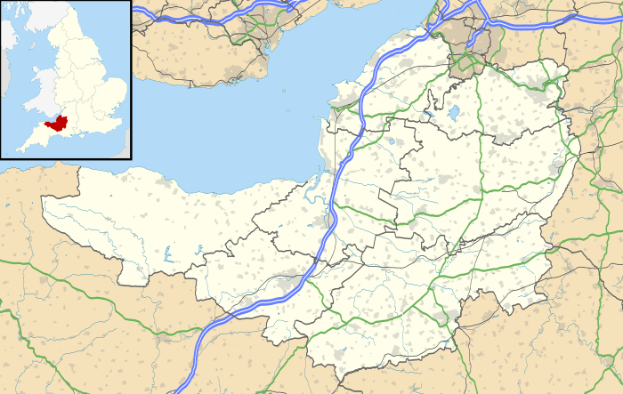 Location of Bow Bridge in Somerset | |
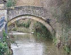
Bow Bridge is a 15th-century Packhorse bridge over the River Brue in Plox, Bruton, Somerset, England. It has been designated as a Grade I listed building,[1] and Scheduled Ancient Monument.[2]
The bridge may have been built as a link between the former Bruton Abbey, and its Court House in the High Street.[1] On the parapet on the western side of the bridge the remains of a carved shield can still be seen.[2] It had acquired the name Bow Bridge by 1707.[3]
The narrow bridge of three arches is 42 inches (1,100 mm) wide. The main arch of the bridge is built from chamfered blocks of dressed stone.[4]
The bridge was restored after floods on 12 July 1982.[5]
See also
References
- 1 2 3 "Bow Bridge". Images of England. English Heritage. Retrieved 2009-07-03.
- 1 2 3 "Bow Bridge (also known as The Packhorse Bridge), Plox (North West side), Bruton". Somerset Historic Environment Record. Somerset County Council. Retrieved 2009-07-03.
- ↑ "Bruton". A History of the County of Somerset: Volume 7: Bruton, Horethorne and Norton Ferris Hundreds (1999), pp. 18-42. British History Online. Retrieved 20 November 2010.
- ↑ Hinchliffe, Ernest (1994). Guide to the Packhorse Bridges of England. Cicerone. pp. 147–148. ISBN 978-1852841430.
- ↑ "Bow Bridge, Bruton". Transport Heritage. Retrieved 20 November 2010.
External links
![]()
This article is issued from
Wikipedia.
The text is licensed under Creative Commons - Attribution - Sharealike.
Additional terms may apply for the media files.