List of public art in Birmingham
This is a list of public art in Birmingham, in the West Midlands county of England. This list applies only to works of public art accessible in an outdoor public space. For example, this does not include artworks in museums.
Central Birmingham/ Ladywood
City Core
Victoria Square
| Image | Title / subject | Location and coordinates |
Date | Artist / designer | Type | Material | Dimensions | Designation | Owner / administrator | Wikidata | Notes |
|---|---|---|---|---|---|---|---|---|---|---|---|
 More images |
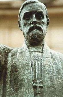
Queen Victoria | Victoria Square 52°28′46″N 1°54′11″W / 52.479536°N 1.903073°W |
1901, 1951 | Thomas Brock, William Bloye | statue | Bronze | Birmingham City Council | Q47460184 | Recast by William Bloye from a marble statue by Thomas Brock[1][2] | ||
 More images |
River, and Youth | Victoria Square 52°28′47″N 1°54′12″W / 52.479626°N 1.90322°W |
c. 1993 | Dhruva Mistry | statues | Bronze | Birmingham City Council | Part of River, Youth, Guardians and Object (Variations)[3][4] In July 2015 the fountain was converted into a flower bed. | |||
 |
Guardian Sphinx 1 | Victoria Square 52°28′46″N 1°54′09″W / 52.479472°N 1.902429°W |
1993 | Dhruva Mistry | statue | Stone | Birmingham City Council | [4] | |||
 |
Guardian Sphinx 2 | Victoria Square 52°28′47″N 1°54′07″W / 52.479693°N 1.901995°W |
1993 | Dhruva Mistry | statue | Stone | Birmingham City Council | [4] | |||
 |
Object (Variations) | Victoria Square | 1993 | Dhruva Mistry | statue | Stone | Birmingham City Council | One of two sculptures collectively known as Object (Variations).[4] | |||
 More images |
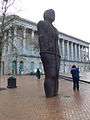
Iron: Man | Victoria Square 52°28′46″N 1°54′09″W / 52.479536°N 1.902484°W |
1993 | Antony Gormley | statue | iron | Birmingham City Council | Q12060795 | The statue was moved into storage on 5 September 2017 until late 2018 (so that the tracks for the Midland Metro extension to Centenary Square can be laid) [5] |
Chamberlain Square
| Image | Title / subject | Location and coordinates |
Date | Artist / designer | Type | Material | Dimensions | Designation | Owner / administrator | Wikidata | Notes |
|---|---|---|---|---|---|---|---|---|---|---|---|
.jpg) More images |
Chamberlain Memorial | Chamberlain Square 52°28′48″N 1°54′15″W / 52.479877°N 1.904259°W |
1880 | John Henry Chamberlain | memorial | Stone | Grade II listed[6] | Birmingham City Council | Q5069586 | Might be affected by the Paradise Circus redevelopment from 2015. But is part of the plans for the new look Chamberlain Square. | |
 More images |
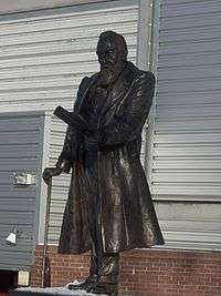
Birmingham Man | Chamberlain Square 52°28′45″N 1°54′21″W / 52.479089°N 1.905724°W |
1993 |
|
statue | Bronze | Birmingham City Council | Q47483006 | Depicts Thomas Attwood. There was also a Soapbox and pages on the steps with the words "Reform", "The Vote". and "The Prosperity".[7][8] Moved into storage in November 2015 due to the Paradise Birmingham scheme. The statue will eventually be returned in the future when Paradise is completed.[9] | ||
 More images |
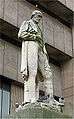
James Watt | Chamberlain Square 52°28′47″N 1°54′16″W / 52.479825°N 1.904566°W |
1868 | Alexander Munro | statue | Stone | Birmingham City Council | Q47467095 | Due to the Paradise, Birmingham redevelopment and the demolition of Birmingham Central Library in 2016, the statue was moved into storage in late September 2015 to the Birmingham Museum Collection Centre [10] The statue will eventually be returned in the future when Paradise is completed.[9] | ||
 More images |
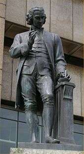
Joseph Priestley | Chamberlain Square 52°28′48″N 1°54′17″W / 52.479923°N 1.904601°W |
1874 | Francis John Williamson | statue | Bronze | Birmingham City Council | Q47467138 | Recast in bronze 1951. Due to the Paradise, Birmingham redevelopment and the demolition of Birmingham Central Library in 2016, the statue was moved into storage in late September 2015 to the Birmingham Museum Collection Centre.[10] The statue will eventually be returned in the future when Paradise is completed.[9] | ||
 More images |
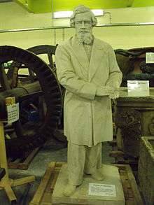
George Dawson | 1880 | Thomas Woolner | Statue | Stone | Grade II listed[11] | Birmingham City Council | Q26339369 | Formerly in Chamberlain Square (near Birmingham Museum and Art Gallery). Presently in storage at the Birmingham Museum Collection Centre. |
Bullring
| Image | Title / subject | Location and coordinates |
Date | Artist / designer | Type | Material | Dimensions | Designation | Owner / administrator | Wikidata | Notes |
|---|---|---|---|---|---|---|---|---|---|---|---|
 More images |
Statue of Horatio Nelson | Bull Ring 52°28′38″N 1°53′38″W / 52.477281°N 1.893949°W |
1809 | Richard Westmacott | statue and railings | Bronze | Grade II* listed[12] | Birmingham City Council | Q7604486 | ||
 More images |
The Guardian | Bull Ring 52°28′40″N 1°53′43″W / 52.477732°N 1.895273°W |
2003 | Laurence Broderick | Bronze | Q47489116 | |||||
 More images |
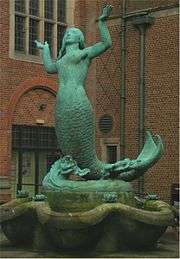
The Tree of Life | Edgbaston Street 52°28′35″N 1°53′44″W / 52.476383°N 1.895424°W |
2005 | Lorenzo Quinn | Bronze | Commemorates civilian victims of the Blitz in Birmingham | |||||
 |
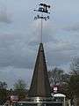
Tree Sculpture | Spiceal Street, Bullring 52°28′37″N 1°53′38″W / 52.476849°N 1.893783°W |
2011 | Wolfgang Buttress | sculpture | copper | Bullring | The 44ft tall tree was made with the reclaimed copper roof from the Spiral Cafe which was removed to make way for the new row of restaurants [13] | |||
.jpg) More images |
24 hour Route | Ramps near the Bull Ring (either side of Rotunda Square) 52°28′41″N 1°53′44″W / 52.478029°N 1.895602°W |
2004 | Anuradha Patel | Railings | Painted Steel | Birmingham City Council | An important pedestrian route between Birmingham New Street station and Birmingham Moor Street station [14] |
Old Square
| Image | Title / subject | Location and coordinates |
Date | Artist / designer | Type | Material | Dimensions | Designation | Owner / administrator | Notes |
|---|---|---|---|---|---|---|---|---|---|---|
 More images |
Tony Hancock | Old Square, Birmingham 52°28′54″N 1°53′43″W / 52.481777°N 1.895411°W |
1996 | Bruce Williams | Steel | Birmingham City Council | [3] | |||
| Old Square | Old Square, Birmingham 52°28′56″N 1°53′42″W / 52.482292°N 1.895002°W |
1967 | Kenneth Budd | Mural | Fibreglass | Birmingham City Council | ||||
 |
Bannatyne's mosaic | Bannatyne's – The Priory Queensway 52°28′55″N 1°53′34″W / 52.481916°N 1.892894°W |
Mosaic | Tiles |
Steelhouse Conservation Area
| Image | Title / subject | Location and coordinates |
Date | Artist / designer | Type | Material | Dimensions | Designation | Owner / administrator | Notes |
|---|---|---|---|---|---|---|---|---|---|---|
 More images |
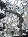
Wattilisk | Queen Elizabeth II Law Courts – Dalton Street / Newton Street 52°28′58″N 1°53′34″W / 52.482739°N 1.892831°W |
1987 | Vincent Woropay | Sculpture | black Indian granite | Birmingham City Council | Depicts James Watt based on Egyptian obelisks and Native American totem poles [15] | ||
.jpg) More images |
Pitman and Murdoch Chambers sculptures | Pitman Chambers and Murdoch Chambers, 153–161 Corporation Street 52°28′58″N 1°53′38″W / 52.482779°N 1.894026°W |
1896 | Benjamin Creswick | Sculpture | Stone | Grade II* listed[16] | |||
.jpg) More images |
Fountain sculpture outside The Wesleyan | The Wesleyan – Colmore Square 52°28′59″N 1°53′48″W / 52.483191°N 1.896708°W |
Sculpture / fountain | Steel | The Wesleyan |
Birmingham New Street station
| Image | Title / subject | Location and coordinates |
Date | Artist / designer | Type | Material | Dimensions | Designation | Owner / administrator | Notes |
|---|---|---|---|---|---|---|---|---|---|---|
 |
Birmingham Figure | John Bright Street (near Hill Street and Navigation Street) 52°28′40″N 1°54′06″W / 52.477779°N 1.901649°W |
1987 | Lea Grandjean | Sculpture | Stone Lepine Lime | Birmingham City Council | [17] The sculpture is getting a revamp in 2016 [18] | ||
.jpg) |
Iron Horse | Birmingham New Street station 52°28′40″N 1°54′03″W / 52.47786°N 1.900827°W |
1987 | Kevin Atherton | sculpture | iron | Network Rail | 12 horses were commissioned in 1987 between Birmingham New Street and Wolverhampton | ||
| Birmingham Pub Bombings Memorial | Will be in the public square outside of Birmingham New Street station | 2018 | Anuradha Patel | Sculpture | Steel | 3 x 15 ft steel trees | Network Rail | There will be three huge sculptural steel trees in memory of the Birmingham Pub Bombings victims of 21st November 1974 [19] |
Great Charles Street Queensway
| Image | Title / subject | Location and coordinates |
Date | Artist / designer | Type | Material | Dimensions | Designation | Owner / administrator | Notes |
|---|---|---|---|---|---|---|---|---|---|---|
 |
Allegories of Art and Industry | Over the north-west door of Birmingham Museum & Art Gallery (The Feeney Gallery extension), Great Charles Street 52°28′52″N 1°54′18″W / 52.4811°N 1.9050°W |
c. 1919 | William Bloye | Stone | Grade II* listed[20] | Birmingham City Council | [1] | ||
 |
Aesculapius | Chest Clinic, Great Charles Street 52°28′54″N 1°54′17″W / 52.4817°N 1.9047°W |
1930 | William Bloye | Stone | [1] |
Colmore Row Business Improvement District
| Image | Title / subject | Location and coordinates |
Date | Artist / designer | Type | Material | Dimensions | Designation | Owner / administrator | Notes |
|---|---|---|---|---|---|---|---|---|---|---|
 |
Charles Gore, First Bishop of Birmingham | Birmingham Cathedral 52°28′52″N 1°53′58″W / 52.481132°N 1.899408°W |
1914 | Thomas Stirling Lee | statue | Bronze | Grade II listed[21] | |||
 |
Burnaby obelisk | Near the Temple Row side of the grounds of Birmingham Cathedral 52°28′51″N 1°53′54″W / 52.480950°N 1.898242°W |
1885 | Robert Bridgeman of Lichfield | War memorial Obelisk | Portland stone | Grade II listed[22] | Burnaby was a military figure who stood unsuccessfully as a Conservative candidate for Birmingham seat in Parliament in 1880. He died in 1885 at the Battle of Abu Klea, Sudan [23] | ||
.jpg) More images |
Angel Drinking Fountain | Birmingham Cathedral - Temple Row 52°28′52″N 1°53′51″W / 52.481156°N 1.897473°W |
1850 | Drinking fountain | Bronze | Grade II listed[24] | Originally stood outside Christ Church at the junction of Colmore Row and New Street. After the church was demolished in 1899 it was moved to Temple Row (outside Birmingham Cathedral).[25] | |||
 More images |
History of Snow Hill | near the bottom of the steps, behind 1 and 9 Colmore Row | 2013 | Oliver Budd | Mural | mosaic | Birmingham City Council | Commemorates Birmingham Snow Hill station. Miniature version of original mural by Kenneth Budd, in St Chad's Circus, which was destroyed in 2007. | ||
.jpg) |
Carousel | West Midlands Police Headquarters – Lloyd House – Snow Hill Queensway 52°29′02″N 1°53′51″W / 52.483904°N 1.897598°W |
1962 | Raymond Forbes King | Sculpture | Painted Fibreglass | West Midlands Police | It was formerly the Carousel Restaurant [26] Lloyd House reopened as of 2017, but this has not returned | ||
.jpg) More images |
The Commuter | Birmingham Snow Hill station 52°29′02″N 1°53′59″W / 52.483902°N 1.899831°W |
1996 | John McKenna | statue | Bronze | Centro | It was moved from the concourse to platform 1 and 2. Was moved again when the station was refurbished | ||
 More images |
'Wisdom, Fortitude, Charity, Faith' | Legal and General Assurance Building, 7 Waterloo Street 52°28′49″N 1°54′00″W / 52.480405°N 1.900024°W |
1932 | William Bloye | Four bas relief panels | Portland Stone ashlar | Exterior high level bas-relief carvings.[1] | |||
 More images |
Capitals and pediment sculptures | New Oxford House, 16 Waterloo Street 52°28′48″N 1°54′05″W / 52.479942°N 1.901489°W |
1935 | William Bloye | Stone | Exterior: two capitals, shield above door and upstairs pediment and putto.[1] | ||||
 More images |
Sun and lettering | Sun Insurance Building, Bennetts Hill 52°28′48″N 1°54′01″W / 52.47991°N 1.90025°W |
1927 | William Bloye | Sun sculpture and lettering | Stone bas-relief[1] | ||||
 |
Lorenzo Ghiberti | 79 – 83 Colmore Row 52°28′52″N 1°54′01″W / 52.481241°N 1.900409°W |
1871 | J. A. Chatwin | sculpture | Stone | Grade II listed[27] | Royal Bank of Scotland | Built for William Spurrier in 1871-3. A silversmith | |
 |
Benvenuto Cellini | 79 – 83 Colmore Row 52°28′52″N 1°54′01″W / 52.481241°N 1.900409°W |
1871 | J. A. Chatwin | sculpture | Stone | Grade II listed[27] | Royal Bank of Scotland | Built for William Spurrier in 1871-3. A silversmith | |
.jpg) |
Allegories of Science and Art | Great Western Arcade Temple Row end 52°28′53″N 1°53′48″W / 52.481479°N 1.896736°W |
1875 | W. H. Ward | Sculpture | Stone, Darley Dale and Bath | Great Western Arcade | [28] |
Cannon Street
| Image | Title / subject | Location and coordinates |
Date | Artist / designer | Type | Material | Dimensions | Designation | Owner / administrator | Notes |
|---|---|---|---|---|---|---|---|---|---|---|
.jpg) |
William Shakespeare 1564-1616 | Cannon Street, Birmingham 52°28′46″N 1°53′54″W / 52.479558°N 1.898220°W |
Sculpture | Birmingham City Council | ||||||
.jpg) |
Sir Walter Scott 1771-1832 | Cannon Street, Birmingham 52°28′47″N 1°53′53″W / 52.479708°N 1.898051°W |
Sculpture | Birmingham City Council |
Ethel Street
| Image | Title / subject | Location and coordinates |
Date | Artist / designer | Type | Material | Dimensions | Designation | Owner / administrator | Wikidata | Notes |
|---|---|---|---|---|---|---|---|---|---|---|---|
.jpg) More images |
Winston Churchill House sculpture | Winston Churchill House, 8 Ethel Street 52°28′45″N 1°54′03″W / 52.479042°N 1.900934°W |
1960s | Sculpture | Bronze | Bronze relief above the entrance of Winston Churchill House. |
Westside
Centenary Square
Baskerville House
| Image | Title / subject | Location and coordinates |
Date | Artist / designer | Type | Material | Dimensions | Designation | Owner / administrator | Notes |
|---|---|---|---|---|---|---|---|---|---|---|
 |
Industry and Genius | Centenary Square Was: 52°28′47″N 1°54′26″W / 52.4796°N 1.9072°W |
1990 | David Patten | Stone | Birmingham City Council | Commemorates John Baskerville. Removed to storage, May 2017[29] | |||
 More images |
King Edward VII Memorial | Centenary Square 52°28′47″N 1°54′25″W / 52.479761°N 1.906921°W |
1913 | Albert Toft | statue | Stone | Grade II listed[30] | Birmingham City Council | Moved from Highgate Park for restoration in 2009. Reerected in Centenary Square, near Baskerville House in 2011. |
Hall of Memory


Library of Birmingham
| Image | Title / subject | Location and coordinates |
Date | Artist / designer | Type | Material | Dimensions | Designation | Owner / administrator | Wikidata | Notes |
|---|---|---|---|---|---|---|---|---|---|---|---|
 More images |
Spirit of Enterprise | 1991 | Tom Lomax | Bronze | Birmingham City Council | Was in Centenary Square; As of 2013 in storage at the Birmingham Museum Collections Centre | |||||
 |
Forward | Centenary Square 52°28′45″N 1°54′29″W / 52.479113°N 1.908175°W |
1991 | Raymond Mason | Statue | Fibreglass | Statue was destroyed by arson on 17 April 2003 | ||||
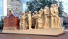
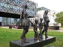 More images |
A Real Birmingham Family | Centenary Square 52°28′45″N 1°54′29″W / 52.479113°N 1.908175°W |
2014 | Gillian Wearing | Statue | Bronze | Ikon Gallery & Library of Birmingham | Q18437761 | As of late May 2017 the statue has gone into storage as work on the Centenary Square redevelopment has started [32] |
Broad Street
| Image | Title / subject | Location and coordinates |
Date | Artist / designer | Type | Material | Dimensions | Designation | Owner / administrator | Wikidata | Notes |
|---|---|---|---|---|---|---|---|---|---|---|---|
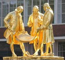 More images |
Boulton, Watt and Murdoch | Broad Street 52°28′43″N 1°54′30″W / 52.478587°N 1.908395°W |
1956 | William Bloye | statues | Gilded Bronze | Statues 285cm high | Birmingham City Council | Q4949742 | Matthew Boulton, James Watt and William Murdoch [33] The statue was moved into storage from late August 2017 until late 2018.[5] It was carefully moved into storage on 23 August 2017 [34] | |
 |
Inner Spirit | Regency Wharf – Broad Street 52°28′41″N 1°54′35″W / 52.478173°N 1.909734°W |
2001 | Amanda Brisbane | Sculpture | Between the Hyatt Regency Hotel and Regency Wharf | |||||
| Reflex Transformer | Reflex / 80s Bar – Broad Street 52°28′41″N 1°54′39″W / 52.47811°N 1.910749°W |
2011 | Sculpture | Reflex Broad Street (Stonegate Pub Company) | Inspired by the 1980's Transformers cartoon and toy line | ||||||
 |
Quayside Tower Reliefs | Podium of Quayside Tower, Broad Street 52°28′38″N 1°54′41″W / 52.477277°N 1.911278°W |
1965 | William Mitchell | Abstract Reliefs | Concrete | Architect, John Madin commissioned Mitchell in 1965. There are approximately 20 panels on the podium structure. |
The ICC
| Image | Title / subject | Location and coordinates |
Date | Artist / designer | Type | Material | Dimensions | Designation | Owner / administrator | Notes |
|---|---|---|---|---|---|---|---|---|---|---|
 |
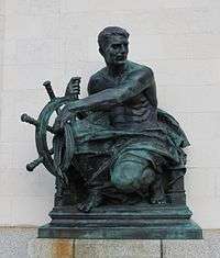
The Battle of Gods and Giants | The ICC (opposite Brindleyplace) 52°28′42″N 1°54′41″W / 52.478406°N 1.911511°W |
1990 | Roderick Tye | sculpture | Bronze | Birmingham City Council | It was intended to symbolise Birmingham's struggle to rebuild its centre. | ||
.jpg) |
Smeaton 1792 | ICC Energy Centre 52°28′45″N 1°54′46″W / 52.479219°N 1.912865°W |
1986 | sculpture | Birmingham City Council | Engineer of the Birmingham & Fazeley Canal (between 1782 to 1789) | ||||
.jpg) |
Telford 1834 | ICC Energy Centre 52°28′45″N 1°54′46″W / 52.479219°N 1.912865°W |
1986 | sculpture | Birmingham City Council | Engineer of the Birmingham Canal Navigations New Main Line (from 1824 to 1827) |
Brindleyplace
| Image | Title / subject | Location and coordinates |
Date | Artist / designer | Type | Material | Dimensions | Designation | Owner / administrator | Notes |
|---|---|---|---|---|---|---|---|---|---|---|
 |
Aqueduct | Central Square, Brindleyplace 52°28′41″N 1°54′50″W / 52.477988°N 1.9139°W |
1995 | Miles Davies | sculpture | Bronze phosphor | Brindleyplace | It was the winning entry in the Brindleyplace PLC competition with the Royal Society of British Sculptors. It is in two pieces, and is in the form of an aqueduct.[35] | ||
 |
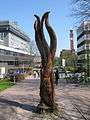
Pergola sculpture | Oozells Square, Brindleyplace 52°28′39″N 1°54′46″W / 52.477412°N 1.912823°W |
1998 | Paul de Monchaux | sculpture | Stone | Brindleyplace | Directly opposite the Ikon Gallery | ||
 |
Future | Cumberland Street – Brindleyplace 52°28′37″N 1°54′47″W / 52.477032°N 1.912983°W |
2004 | Robert Bowers | sculpture / statue | Bronze | Brindleyplace | Located between 8 Brindleyplace and 10 Brindleyplace | ||
 |
Gates | Sheepcote Street – Brindleyplace 52°28′35″N 1°54′53″W / 52.476467°N 1.914586°W |
1995 | Miles Davies | sculpture | Bronze phosphor | Brindleyplace | On the roundabout on Sheepcote Street, close to Brunswick Square and the Brasshouse Language Centre |
The Cube
| Image | Title / subject | Location and coordinates |
Date | Artist / designer | Type | Material | Dimensions | Designation | Owner / administrator | Notes |
|---|---|---|---|---|---|---|---|---|---|---|
 |
Diving Sculpture | Waterfront Walk – Worcester & Birmingham Canal, opposite The Cube 52°28′31″N 1°54′28″W / 52.4752°N 1.907826°W |
2006 | Cathy Lewis | statue | Bronze | Charles Church Developments | Near the Register Office – Holliday Wharf | ||
 |
The Lovely People – Urban | The Cube 52°28′31″N 1°54′25″W / 52.475213°N 1.906956°W |
2010 | Temper | statue | Bronze | The Cube | |||
.jpg) |
Pen nib | Washington Wharf opposite Waterfront Walk – Worcester & Birmingham Canal 52°28′29″N 1°54′29″W / 52.474801°N 1.908166°W |
Sculpture | |||||||
 |
Anglepoise | Entrance to The Mailbox, Birmingham 52°28′33″N 1°54′16″W / 52.4758624°N 1.9045711°W |
2014 | Holmes Wood, consultancy | Sculpture |
Ladywood / Five Ways
Five Ways
| Image | Title / subject | Location and coordinates |
Date | Artist / designer | Type | Material | Dimensions | Designation | Owner / administrator | Wikidata | Notes |
|---|---|---|---|---|---|---|---|---|---|---|---|
 More images |
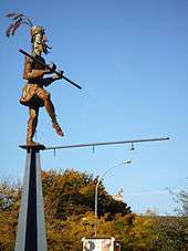
Joseph Sturge memorial | Five Ways Island in front of the Marriott Hotel (near Harborne Road) 52°28′20″N 1°55′09″W / 52.472195°N 1.919195°W |
1862 | John Thomas | statue | Portland stone | Grade II listed[36] | Birmingham City Council | Q15980195 | Commemorates Joseph Sturge. Restored in 2007 | |
 |
Stainless Steel Sculpture | Five Ways Island 52°28′23″N 1°55′07″W / 52.472923°N 1.918478°W |
1973 | Alexander Mann | sculpture | Stainless steel | Birmingham City Council | ||||
.jpg) More images |
Claude Auchinleck | Outside Park Regis Hotel - Broad Street, Birmingham 52°28′24″N 1°55′01″W / 52.473414°N 1.917035°W |
1965 | Fiore De Henriques | Statue | Bronze | Park Regis Hotel Birmingham | [37] Went into storage between 2013 and 2015 during the revelopment of the Five Ways Shopping Centre into the Park Regis Hotel. It was moved to a different location close to Broad Street in November 2015. The hotel will open by March 2016.[38] |
Ladywood
| Image | Title / subject | Location and coordinates |
Date | Artist / designer | Type | Material | Dimensions | Designation | Owner / administrator | Notes |
|---|---|---|---|---|---|---|---|---|---|---|
 |
Charles Blondin | Ladywood Middleway 52°28′36″N 1°55′30″W / 52.4766°N 1.9251°W |
1993 | Paul Richardson | statue | Steel | Birmingham City Council | |||
 |
The Galloping Courier | Tesco – Spring Hill, Ladywood 52°29′06″N 1°55′13″W / 52.485124°N 1.920191°W |
Public transport interchange | Steel | Centro | |||||
 |
The Nonsens | Ladywood Middleway, Spring Hill, Ladywood 52°29′04″N 1°55′14″W / 52.484478°N 1.920468°W |
Public transport interchange | Steel | Centro | |||||
.jpg) More images |
Peace Garden railings | St. Thomas' Peace Garden 52°28′24″N 1°54′22″W / 52.4734°N 1.9060°W |
1995 | Anuradha Patel | Railings and gates | Steel | Steel gates and railings. With help from the students of Lea Mason Church of England Secondary School and other groups [39] | |||
.jpg) More images |
Cutting Edge | Northbrook Street 52°29′08″N 1°55′56″W / 52.485661°N 1.932223°W |
2006 | Anuradha Patel | Railings | Steel | Steel railings above the Birmingham Canal Main Line.[40] |
Highgate
| Image | Title / subject | Location and coordinates |
Date | Artist / designer | Type | Material | Dimensions | Designation | Owner / administrator | Notes |
|---|---|---|---|---|---|---|---|---|---|---|
 More images |
Beorma Ingas Ham | Gooch Street Bridge, Highgate 52°27′59″N 1°53′34″W / 52.466434°N 1.892721°W |
2006 | Pair of decorative arches | Steel | Birmingham City Council | On a bridge over the Rea, marking the spot nearby where Birmingham was first settled | |||
 More images |
Highgate entrance sculptures | Belgrave Middleway near Horton Square, Highgate 52°27′54″N 1°53′31″W / 52.464937°N 1.892020°W |
Pair of sculptures | Steel | Birmingham City Council | The left side has "aet thaere" on it. The right side has "ea" on it. |
Eastside / Aston University
| Image | Title / subject | Location and coordinates |
Date | Artist / designer | Type | Material | Dimensions | Designation | Owner / administrator | Notes |
|---|---|---|---|---|---|---|---|---|---|---|
 More images |
Hebe | James Watt Queensway 52°29′04″N 1°53′32″W / 52.484385°N 1.892165°W |
1966 | Robert Thomas | statue | Bronze | Birmingham City Council | Used to be in Holloway Circus, before being moved to James Watt Queensway, with a new surround, by Anuradha Patel.[41] | ||
 |
Inside Tempus Fugit | Aston University Library 52°29′09″N 1°53′20″W / 52.485831°N 1.888826°W |
2004 | Ray Lonsdale | bust | Stainless steel | Aston University | Previously near the Aston University Day Hospital, now in front of the Aston University Library.[42] There is a figure of a small boy inside the head [43] | ||
.jpg) More images |
Peace Sculpture | The lake near Lakeside – Aston University 52°29′02″N 1°53′22″W / 52.484005°N 1.889466°W |
1985 | William Pye | Sculpture / fountain | Stainless steel | Aston University | Commissioned by West Midlands County Council; originally for Ackers Park,[44][45] | ||
 More images |
Tipping Triangles | Behind the main building of Aston University 52°29′13″N 1°53′18″W / 52.487022°N 1.888377°W |
1994 | Angela Conner | Sculpture / fountain | Stainless steel | 5.4m high | Aston University | Provides beauty and tranquillity whilst using the university's triangle symbol [46][47] | |
 More images |
Aston Stones | Various locations around Aston University 52°29′09″N 1°53′16″W / 52.485714°N 1.887723°W |
1975 - 1977 | John Maine | Sculpture | Portland stone | heights range from 1.05m to 1.35m | Aston University | A series of five abstract Portland stones on different parts of the campus [48] | |
 More images |
Eastside City Park | Eastside City Park 52°28′55″N 1°53′16″W / 52.4820°N 1.8877°W |
2012 | Patel Taylor | Sculpture | Steel | Birmingham City Council | [49] |
Digbeth
.jpg)
.jpg)
.jpg)
.jpg)
Southside
| Image | Title / subject | Location and coordinates |
Date | Artist / designer | Type | Material | Dimensions | Designation | Owner / administrator | Notes |
|---|---|---|---|---|---|---|---|---|---|---|
 More images |
Horsefair, 1908 | Holloway Circus 52°28′30″N 1°54′01″W / 52.474918°N 1.900173°W |
1967 | Kenneth Budd | Mosaic mural | Birmingham City Council | ||||
 More images |
Chinese Pagoda | Holloway Circus 52°28′29″N 1°54′01″W / 52.474853°N 1.900416°W |
1998 | Chinese pagoda | Stone | Birmingham City Council | The pagoda was carved in Fujian, a province of China. It was donated to the city, and forms a landmark of the nearby Chinese Quarter. | |||
.jpg) More images |
Chinese Guardian dogs | Holloway Circus 52°28′30″N 1°54′02″W / 52.474906°N 1.900645°W |
Sculpture | Bronze | Birmingham City Council | |||||
.jpg) |
Marilyn Monroe | Missing - Hurst Street in the Gay Quarter 52°28′25″N 1°53′46″W / 52.473735°N 1.896077°W |
Statue | Missing Bar | It has been on the wall of Missing since at least 2009 or earlier. | |||||
.jpg) |
Rhinestone Rhino | Hurst Street and Bromsgrove Street in the Gay Quarter 52°28′24″N 1°53′46″W / 52.473365°N 1.896056°W |
2012 | Emma Butler, Vikki Litton and Robbie Coleman | Sculpture | polystyrene mould, carved into a rhino shape and then coated in fibreglass. | Southside BID | Unveiled in time for Birmingham Pride in June 2012 [52] |
Jewellery Quarter
| Image | Title / subject | Location and coordinates |
Date | Artist / designer | Type | Material | Dimensions | Designation | Owner / administrator | Notes |
|---|---|---|---|---|---|---|---|---|---|---|
.jpg) |
Clockwork | Jewellery Quarter station, Vyse Street, Hockley (Jewellery Quarter) 52°29′22″N 1°54′46″W / 52.4894°N 1.912775°W |
2004 | Mick Thacker and Mark Renn | Public transport interchange | Steel | Centro | |||
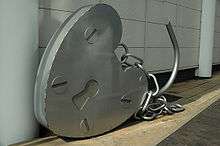 |
Padlock | Newhall Hill – Jewellery Quarter 52°28′57″N 1°54′39″W / 52.482547°N 1.910892°W |
2000 | Mick Thacker and Mark Renn | sculpture | Steel | [53] | |||
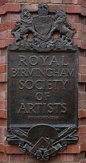 |
RBSA bronze plaques | Royal Birmingham Society of Artists – 4 Brook Street, Jewellery Quarter 52°29′06″N 1°54′27″W / 52.484891°N 1.907520°W |
1919 | William Bloye | Bronze plaques | Bronze | Royal Birmingham Society of Artists | Formerly at the Society's old headquarters on New Street[1] | ||
 |
The Jewellery Quarter – Newhall Street Gateway | Newhall Street with Lionel Street, Jewellery Quarter 52°28′59″N 1°54′19″W / 52.483116°N 1.905140°W |
2003 | Anuradha Patel | Sculpture | Steel | Birmingham City Council | |||
 |
The Jewellery Quarter – Vyse Street Gateway | Vyse Street with Great Hampton Street, Jewellery Quarter 52°29′29″N 1°54′40″W / 52.491351°N 1.911202°W |
2003 | Anuradha Patel | Sculpture | Steel | Birmingham City Council | |||
 |
The Jewellery Quarter – Hall Street Gateway | Hall Street with Great Hampton Street, Jewellery Quarter 52°29′20″N 1°54′28″W / 52.488958°N 1.907824°W |
2003 | Anuradha Patel | Sculpture | Steel | Birmingham City Council | |||
.jpg) |
Manangel | The Jam House – 3 – 5 St Paul's Square, Jewellery Quarter 52°29′06″N 1°54′18″W / 52.484955°N 1.904872°W |
2001 | David Begbie | Sculpture | wire-mesh | The Jam House | Looks like a netted angel. It was missing since August 2016 [54] but as of January 2017 it is back |
Gun Quarter
| Image | Title / subject | Location and coordinates |
Date | Artist / designer | Type | Material | Dimensions | Designation | Owner / administrator | Notes |
|---|---|---|---|---|---|---|---|---|---|---|
| Swing | It was at St Chad's Circus | 1988 | Kevin Atherton | Sculpture | Mild steel (electro-plated) | Birmingham City Council | Was in St Chad's Circus from 1990, but the site has since been redeveloped and has been removed [55] |
Acocks Green
| Image | Title / subject | Location and coordinates |
Date | Artist / designer | Type | Material | Dimensions | Designation | Owner / administrator | Notes |
|---|---|---|---|---|---|---|---|---|---|---|
.jpg) More images |
Acocks Green Village in Bloom - Gold | Acocks Green Village Green 52°26′47″N 1°49′25″W / 52.446270°N 1.823506°W |
May 2017 | Veronica Treadwell | Sculpture | Acocks Green Village BID | Based on the design of a tree. Represents a canal, then a railway [56] | |||
 |
Fox and Holly | Corner of Olton Boulevard East and Shaftmoor Lane in Acocks Green 52°26′38″N 1°50′05″W / 52.443973°N 1.834728°W |
2003 | Rosemary Terry | Public transport interchange | Wood & Steel | Centro | Named after the Fox Hollies area that it is in. The name dates back to 1465. | ||
 |
Fox and Hollybush | Lidl – Olton Boulevard East, Acocks Green 52°26′39″N 1°50′03″W / 52.444116°N 1.834154°W |
1927 | William Bloye | relief sculpture | sandstone | It used to be on the wall of now demolished Fox and Hollybush pub. Now on the left of Lidl, in the Fox Hollies area of Acocks Green. | |||
 |
Fox Hollies Lidl sculpture | Lidl – Summer Road & Olton Boulevard East, Acocks Green 52°26′39″N 1°50′03″W / 52.444198°N 1.834239°W |
Sculpture / railings | Painted steel | ||||||
 |
Sculpture of a bird on the Great Western pub | Great Western – 10 Yardley Road, Acocks Green 52°27′01″N 1°49′09″W / 52.450171°N 1.819085°W |
Stone | |||||||
.jpg) More images |
John Bridgeman play sculpture | Curtis Gardens, Fox Hollies Road, Acocks Green 52°26′26″N 1°50′06″W / 52.440554°N 1.835103°W |
c1960 | John Bridgeman | Sculpture | Concrete | Grade II listed since 2015[57][58] | Birmingham City Council | ||
| Westley Vale Millennium Green mural | Westley Vale Millennium Green - The Avenue, Acocks Green 52°26′57″N 1°48′57″W / 52.449140°N 1.815860°W |
2015 | Hoakser | Mural | Spray paint | Westley Vale Millennium Green, Community First & Arts in the Yard | See photo on Flickr Westley Vale Millennium Green mural |
Aston
| Image | Title / subject | Location and coordinates |
Date | Artist / designer | Type | Material | Dimensions | Designation | Owner / administrator | Notes |
|---|---|---|---|---|---|---|---|---|---|---|
 |
William McGregor | Villa Park – Trinity Road, Aston 52°30′31″N 1°53′11″W / 52.508744°N 1.886341°W |
2009 | Sam Holland | statue | Bronze | Aston Villa | |||
.jpg) More images |
Face to Face | Waterlinks Boulevard with Park Circus, Aston 52°30′07″N 1°52′59″W / 52.501829°N 1.882975°W |
1993 | Ray Smith | Sculpture | Painted steel | 600 x 400cm | Birmingham City Council | One of the Gateway to Heartlands sculptures [59] |
Newtown
| Image | Title / subject | Location and coordinates |
Date | Artist / designer | Type | Material | Dimensions | Designation | Owner / administrator | Notes |
|---|---|---|---|---|---|---|---|---|---|---|
.jpg) |
Lucas' Lion, Wheel, and Flambear emblem | 36, Wheeler Street, Newtown 52°29′46″N 1°54′14″W / 52.49603°N 1.90376°W |
November 1998 | John McKenna | Stainless steel | Midland Area Housing Association | On the side of house, built on the site of the former Lucas factory.[60][61] | |||
 More images |
Joseph Lucas Monument | Great King Street North, Newtown 52°29′40″N 1°54′32″W / 52.494549°N 1.908981°W |
1994 | Sculpture | Slate | 3m x 60cm x 1m | It's on the site of what was the Tom Bowling Lamp Factory that was in Little King Street from 1872.[60][62] | |||
.jpg) |
Burbury Park sculpture | Burbury Park, Newtown 52°29′50″N 1°54′16″W / 52.497115°N 1.904381°W |
Stainless steel | |||||||
 |
Mondobongo | Corner of High Street and Burlington Street in Newtown 52°29′55″N 1°53′42″W / 52.498694°N 1.895002°W |
Mark Renn & Mick Thacker | Public transport interchange | Steel | Centro | ||||
 |
An even bigger splash! | Newtown Swimming Pool & Fitness Centre, High Street, Newtown 52°29′57″N 1°53′46″W / 52.499162°N 1.895976°W |
Mark Renn & Mick Thacker | Public transport interchange | Steel | Centro |
Bartley Green
| Image | Title / subject | Location and coordinates |
Date | Artist / designer | Type | Material | Dimensions | Designation | Owner / administrator | Notes |
|---|---|---|---|---|---|---|---|---|---|---|
 More images |
Talking about the Weather | Field Lane, Bartley Green opposite Romsley Road 52°26′04″N 2°00′17″W / 52.434333°N 2.004596°W |
2004 | Pamina Stewart, Mark Renn & Mick Thacker | Public transport interchange | Steel | Centro | |||
.jpg) |
Bus bench sculpture | Corner of Romsley Road and Field Lane, Bartley Green 52°26′05″N 2°00′18″W / 52.434678°N 2.005113°W |
Bench | Painted Steel | Centro | Is near the Bartley Green bus terminus area | ||||
.jpg) More images |
The Globe | Newman University, Genners Lane, Bartley Green 52°25′59″N 1°59′40″W / 52.433050°N 1.994405°W |
May 2012 | Julie Edwards & Ron Thompson of Planet Art | Globe sculpture | Stainless steel | Newman University | The Globe represents how Newman University is recognised globally with international links and worldwide connections [63] | ||
.jpg) More images |
Remains of a Pyramid | Senneleys Park, Bartley Green 52°26′13″N 1°59′10″W / 52.436911°N 1.986123°W |
1989 - 1991 | Avtarjeet Dhanjal | Sculpture | Portland stone | 10 x 10 x 2.5m high | Birmingham City Council | The bronze figure is missing [64] |
Billesley
| Image | Title / subject | Location and coordinates |
Date | Artist / designer | Type | Material | Dimensions | Designation | Owner / administrator | Notes |
|---|---|---|---|---|---|---|---|---|---|---|
 More images |
The Swan of Swan Corner | Roundabout at Brook Lane (between Coldbath Road and Wheelers Lane), Billesley 52°25′52″N 1°52′36″W / 52.431192°N 1.876752°W |
2014 | swan sculpture | Wood | Swan Corner | Unveiled by members of Swan Corner on 18 November 2014 [65]
As of January 2017, the head and half of the neck is missing |
Bordesley Green
| Image | Title / subject | Location and coordinates |
Date | Artist / designer | Type | Material | Dimensions | Designation | Owner / administrator | Notes |
|---|---|---|---|---|---|---|---|---|---|---|
 |
Juggernaut | Victoria Street, Bordesley Green 52°28′36″N 1°51′23″W / 52.47654°N 1.856401°W |
2004 | Mick Thacker and Mark Renn | Public transport interchange | Steel | Centro | |||
 More images |
Sleeping Iron Giant | Garrison Lane, Bordesley Green 52°28′34″N 1°51′39″W / 52.476064°N 1.860902°W |
1992 | Ondre Nowakowski | Sculpture | Iron, sintered, Polyester resin, on steel reinforced frame | 1.4 x 2.44m | Birmingham City Council | A metaphor for a site with an historic background of manufacturing industry.[66] |
Bournville
| Image | Title / subject | Location and coordinates |
Date | Artist / designer | Type | Material | Dimensions | Designation | Owner / administrator | Notes |
|---|---|---|---|---|---|---|---|---|---|---|
 |
George Cadbury | Friends Meeting House – Linden Road, Bournville 52°25′49″N 1°56′09″W / 52.430372°N 1.935903°W |
1924 | Francis Wood | bust | Bronze | Bournville Village Trust | Seen from the Bournville Village Green | ||
.jpg) More images |
Terpischore | Cadbury Factory grounds – Bournville Lane, Bournville 52°25′40″N 1°55′58″W / 52.427796°N 1.932671°W |
1932 | William Bloye | Statue on a fountain | Bronze | Cadbury | [67] |
Castle Vale
| Image | Title / subject | Location and coordinates |
Date | Artist / designer | Type | Material | Dimensions | Designation | Owner / administrator | Notes |
|---|---|---|---|---|---|---|---|---|---|---|
 More images |
Sentinel | Spitfire Island 52°30′48″N 1°47′55″W / 52.513297°N 1.798673°W |
2000 | Tim Tolkien | Steel |
Cotteridge
| Image | Title / subject | Location and coordinates |
Date | Artist / designer | Type | Material | Dimensions | Designation | Owner / administrator | Notes |
|---|---|---|---|---|---|---|---|---|---|---|
 |
Feathers Of Freedom | Near Sophies – Pershore Road South, Cotteridge 52°24′57″N 1°55′51″W / 52.415796°N 1.930945°W |
2001 | Paula Woof | Public transport interchange | Steel | Centro | There is also similar feathers sculpture as the entrance of the overflow car park at Kings Norton Station | ||
| Cotteridge Park mural | Railway bridge leading into Cotteridge Park near Breedon Road, Cotteridge 52°25′11″N 1°55′35″W / 52.419742°N 1.926491°W |
2012 | Daniel "Newso" Lickiss | Mural | Spray paint | Friends of Cotteridge Park, Birmingham City Council & Network Rail | Created to prevent vandalism and graffiti on the bridge [68] Please see the photos here on Flickr Cotteridge Park – railway bridge – artwork – dogs – dalmatian |
Duddeston
| Image | Title / subject | Location and coordinates |
Date | Artist / designer | Type | Material | Dimensions | Designation | Owner / administrator | Notes |
|---|---|---|---|---|---|---|---|---|---|---|
.jpg) |
Face #1 | Duddeston Station 52°29′16″N 1°52′17″W / 52.487873°N 1.871457°W |
sculpture | Steel | London Midland | |||||
.jpg) |
Face #2 | Duddeston Station 52°29′16″N 1°52′17″W / 52.487873°N 1.871457°W |
sculpture | Steel | London Midland | |||||
.jpg) |
Face #3 | Duddeston Station 52°29′16″N 1°52′17″W / 52.487873°N 1.871457°W |
sculpture | Steel | London Midland | |||||
.jpg) |
Hand | Duddeston Station 52°29′16″N 1°52′17″W / 52.487873°N 1.871457°W |
sculpture | Steel | London Midland | |||||
.jpg) |
Red Amber Green | Duddeston Station 52°29′16″N 1°52′17″W / 52.487873°N 1.871457°W |
sculpture | Steel | London Midland | |||||
.jpg) |
Diving Bodies | Duddeston Station 52°29′19″N 1°52′16″W / 52.488673°N 1.871071°W |
sculpture | Steel | London Midland | |||||
 |
Youth | Melvina Road, Duddeston 52°29′31″N 1°52′13″W / 52.491864°N 1.870223°W |
1958 | Harry Seager | statue | Concrete | Birmingham City Council | [69] |
Edgbaston
| Image | Title / subject | Location and coordinates |
Date | Artist / designer | Type | Material | Dimensions | Designation | Owner / administrator | Notes |
|---|---|---|---|---|---|---|---|---|---|---|
.jpg) |
Edgbaston Interchange | Priory Road, Edgbaston, near Bristol Road (and Century Tower) 52°27′21″N 1°54′35″W / 52.455746°N 1.909746°W |
Public transport interchange | Steel | Centro | |||||
 |
Map of Edgbaston | Morrisons – near Harborne Road, Edgbaston 52°28′17″N 1°55′17″W / 52.471475°N 1.921268°W |
2013 | sculpture | Steel | Morrisons | Fountain with leaf design on the reverse | |||
 |
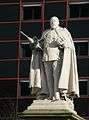
Robert Peel | Outside Tally Ho – Pershore Road, Edgbaston 52°27′16″N 1°54′26″W / 52.454546°N 1.907328°W |
1855 | Peter Hollins | statue | Bronze | Grade II listed[70] | Birmingham City Council | Originally on Congreve Street, then moved to Council House Square in 1873 (now Victoria Square). Moved to Calthorpe Park in 1926. Then to Pershore Road in 1963. Original plinth still in Calthorpe Park. | |
 |
Boer War Memorial | Cannon Hill Park 52°27′12″N 1°54′04″W / 52.453264°N 1.90099°W |
1905 | Albert Toft | war memorial statue | Bronze | Birmingham City Council | Refurbished in 2012 | ||
.jpg) |
Golfer | Golden Putter Mini-Golf, Cannon Hill Park 52°27′11″N 1°54′06″W / 52.452937°N 1.901794°W |
2014 | statue | Birmingham City Council | A new 36 hole course opened at Cannon Hill Park in 2014 [71] | ||||
.jpg) |
Nature Centre Sign | Birmingham Wildlife Conservation Park, Pershore Road, Edgbaston 52°27′01″N 1°54′39″W / 52.450345°N 1.910847°W |
1990 | Sheila Carter and Family | Sculpture | Wrought iron, egg-shell black finish and gold leaf highlights | Birmingham City Council | A large circle representing the months of the year.[72] |
Queen Elizabeth Hospital Birmingham
| Image | Title / subject | Location and coordinates |
Date | Artist / designer | Type | Material | Dimensions | Designation | Owner / administrator | Notes |
|---|---|---|---|---|---|---|---|---|---|---|
 |
Maternity statue | Birmingham Women's Hospital 52°27′13″N 1°56′31″W / 52.453697°N 1.942062°W |
statue | Bronze | Birmingham Women's Hospital | |||||
 |
The Future | Queen Elizabeth Hospital Birmingham 52°27′05″N 1°56′28″W / 52.451473°N 1.94124°W |
2013 | Richard Thornton | sculpture | Stainless steel | Queen Elizabeth Hospital Birmingham | A competition was held in 2012 to name it.[73] In the shape of a Double Helix. Celebrates the coming together of the previous hospitals on one site [43] | ||
_(2).jpg) More images |
The Good Samaritan | Queen Elizabeth Hospital Birmingham 52°27′05″N 1°56′26″W / 52.451350°N 1.940686°W |
1963 | Uli Nimptsch | statue | Bronze | Moved in 2014 to a path between the Queen Elizabeth Hospital and University of Birmingham in Edgbaston [74] |
University of Birmingham


.jpg)
.jpg)

.jpg)
Erdington
| Image | Title / subject | Location and coordinates |
Date | Artist / designer | Type | Material | Dimensions | Designation | Owner / administrator | Notes |
|---|---|---|---|---|---|---|---|---|---|---|
 |
Sir Josiah Mason | Island at Chester Road and Orphanage Road in Erdington 52°31′54″N 1°49′30″W / 52.531575°N 1.825115°W |
1951 | William Bloye | bust | Bronze | Birmingham City Council | Recast by William Bloye in 1951, from an 1885 statue by Francis John Williamson (now lost).[1] | ||
 |
Insect and Celtic Cross | Erdington Station 52°31′40″N 1°50′23″W / 52.527844°N 1.839714°W |
1998 | Ronald Rae | sculpture | Stone | London Midland / Centro | [78] | ||
.jpg) More images |
The Feast | McDonald's – corner of Chester Road and Sutton Road, Erdington 52°31′59″N 1°49′44″W / 52.533068°N 1.828880°W |
Anuradha Patel | Screen | Represents a community coming together to celebrate [79] |
Garretts Green
| Image | Title / subject | Location and coordinates |
Date | Artist / designer | Type | Material | Dimensions | Designation | Owner / administrator | Notes |
|---|---|---|---|---|---|---|---|---|---|---|
.jpg) |
Fire Fighters | Sheldon Community Fire Station - Garretts Green Lane, Garretts Green 52°28′38″N 1°46′51″W / 52.477325°N 1.780816°W |
1954 | Robert Pancheri | Mural | Stone | West Midlands Fire Service | The fire station opened in December 1956. It was the first fire station to open in Birmingham after World War II.[80] |
Great Barr
| Image | Title / subject | Location and coordinates |
Date | Artist / designer | Type | Material | Dimensions | Designation | Owner / administrator | Notes |
|---|---|---|---|---|---|---|---|---|---|---|
 More images |
Moonstones | Periphery of Asda supermarket, Queslett Road 52°33′10″N 1°54′31″W / 52.55273°N 1.90862°W |
Steve Field | Carvings | Sandstone | Set of eight memorials to members of the Lunar Society | ||||
 |
Beech Beacon | Shipway – Walsall Road, Great Barr 52°32′40″N 1°55′52″W / 52.54455°N 1.931045°W |
Public transport interchange | Steel | Centro | |||||
 |
The Towers | Tower Hill, Great Barr 52°32′08″N 1°55′14″W / 52.53567°N 1.92044°W |
1936 | William Bloye | Stone | Front of pub. Bloye was responsible for all the stone carving on this brick building[1] | ||||
 |
The Towers | Tower Hill, Great Barr 52°32′08″N 1°55′15″W / 52.53553°N 1.92072°W |
1936 | William Bloye | Stone | Rear of pub. Bloye was responsible for all the stone carving on this brick building[1] |
Harborne
| Image | Title / subject | Location and coordinates |
Date | Artist / designer | Type | Material | Dimensions | Designation | Owner / administrator | Notes |
|---|---|---|---|---|---|---|---|---|---|---|
 |
Huntsman and Dog | The Green Man, High Street, Harborne 52°27′41″N 1°56′35″W / 52.46138°N 1.94301°W |
c. 1940 | William Bloye | pub sign | Wood | Painted wooden pub sign.[1] | |||
 |
The Olympic Diamond | High Street, Harborne 52°27′37″N 1°56′41″W / 52.460174°N 1.944817°W |
2012 | The children of St Mary's Catholic Primary School and Harborne Primary School. | mosaic | Commemorates the London 2012 Olympics and the Diamond Jubilee of the Queen [81] |
Hall Green
| Image | Title / subject | Location and coordinates |
Date | Artist / designer | Type | Material | Dimensions | Designation | Owner / administrator | Notes |
|---|---|---|---|---|---|---|---|---|---|---|
 |
Dragon bench sculpture | Hall Green Library – Stratford Road, Hall Green 52°26′02″N 1°50′47″W / 52.433768°N 1.846332°W |
Students of Hall Green School (?) | bench sculpture | Wood | Hall Green Library | Might be based on Smaug from The Hobbit by J.R.R. Tolkien (who lived nearby in Sarehole in the early 1900s (as a small boy). | |||
 |
Middle Earth | Hall Green Library – Stratford Road, Hall Green 52°26′01″N 1°50′47″W / 52.433649°N 1.846326°W |
Mural | Hall Green Library | Mural inspired by J.R.R. Tolkien who lived nearby in the early 1900s in the Sarehole area | |||||
.jpg) |
Dragonfly heart Mosaic | Greet Mill Meadow - Shire Country Park - Stratford Road, Hall Green 52°26′35″N 1°51′20″W / 52.443154°N 1.855466°W |
mosaic | Glass tiles | Birmingham City Council | Not far from the Stratford Road bridge and the River Cole | ||||
.jpg) |
Fish Mosaic | Greet Mill Meadow - Shire Country Park - Green Road, Hall Green 52°26′12″N 1°51′21″W / 52.436741°N 1.855766°W |
mosaic | Glass tiles | Birmingham City Council | Close to the flooded part of the River Cole on Green Road |
Handsworth
| Image | Title / subject | Location and coordinates |
Date | Artist / designer | Type | Material | Dimensions | Designation | Owner / administrator | Notes |
|---|---|---|---|---|---|---|---|---|---|---|
 |
Tulip Tree | Barn Lane and Soho Road, Handsworth 52°30′14″N 1°56′14″W / 52.503758°N 1.937298°W |
Public transport interchange | Wood | Centro | |||||
 |
Under the Sun | Soho Hill, corner of St. Michaels Road 52°30′03″N 1°55′24″W / 52.500784°N 1.923367°W |
2010 | Saranjit Birdi | Sculpture | Steel |
Hockley
| Image | Title / subject | Location and coordinates |
Date | Artist / designer | Type | Material | Dimensions | Designation | Owner / administrator | Notes |
|---|---|---|---|---|---|---|---|---|---|---|
 More images |
Climbing wall | Hockley Flyover 52°29′43″N 1°54′55″W / 52.4954°N 1.9153°W |
1968 | William Mitchell | Cast concrete | Birmingham City Council | [82] | |||
 |
Coin Stack | Soho Hill – Hockley Circus – Hockley 52°29′46″N 1°54′57″W / 52.496024°N 1.915815°W |
Public transport interchange | Steel | Centro |
Kings Heath
| Image | Title / subject | Location and coordinates |
Date | Artist / designer | Type | Material | Dimensions | Designation | Owner / administrator | Notes |
|---|---|---|---|---|---|---|---|---|---|---|
 More images |
Wing Wheel | Alcester Road South, Kings Heath (opposite The Crown pub) 52°25′16″N 1°53′31″W / 52.421178°N 1.891827°W |
2004 | Anuradha Patel | Public transport interchange | Steel | Centro | The Kings Heath Interchange. Relates to the theme of journey and literal references to transport |
Kings Norton
| Image | Title / subject | Location and coordinates |
Date | Artist / designer | Type | Material | Dimensions | Designation | Owner / administrator | Notes |
|---|---|---|---|---|---|---|---|---|---|---|
.jpg) |
Feathers | Kings Norton Station overflow car park 52°24′49″N 1°56′08″W / 52.413557°N 1.935618°W |
Paula Woof | Sculpture | Steel | Centro | Pair of steel feathers above height barriers. Also a feather above a mosaic on the ground | |||
| Kings Norton Past to Present | Far footbridge – Kings Norton Station 52°24′50″N 1°56′07″W / 52.413977°N 1.935331°W |
2012 | Daniel "Newso" Lickiss (with Adeela Ahmad of Kings Norton Girls School and Oliver Blackburn, of Kings Norton Boys School) | Mural | Spray paint | Centro, Birmingham City Council & Network Rail | Footbridge given a makeover by local graffiti artist [83] See photo on Flickr Kings Norton Past to Present |
Kingstanding
| Image | Title / subject | Location and coordinates |
Date | Artist / designer | Type | Material | Dimensions | Designation | Owner / administrator | Notes |
|---|---|---|---|---|---|---|---|---|---|---|
 |
The Mysterious Green Man | Roundabout between Kingstanding Road and Kings Road, Kingstanding 52°33′10″N 1°53′02″W / 52.552728°N 1.88399°W |
2004 | Jason Cleverly | Public transport interchange | Steel | Centro | |||
 |
The Multi Faceted Green Man | Roundabout between Kingstanding Road and Rough Road, Kingstanding 52°33′12″N 1°53′02″W / 52.553363°N 1.883805°W |
2004 | Jason Cleverly | Public transport interchange | Steel | Centro |
Longbridge
| Image | Title / subject | Location and coordinates |
Date | Artist / designer | Type | Material | Dimensions | Designation | Owner / administrator | Notes |
|---|---|---|---|---|---|---|---|---|---|---|
 More images |
The Genie of Industry | Longbridge Lane, Longbridge 52°23′44″N 1°58′56″W / 52.395518°N 1.982321°W |
John McKenna | Public transport interchange | Steel | Centro | It's close to Longbridge Station, was formerly on the other side of the road (was moved in 2014) |
Lozells
| Image | Title / subject | Location and coordinates |
Date | Artist / designer | Type | Material | Dimensions | Designation | Owner / administrator | Notes |
|---|---|---|---|---|---|---|---|---|---|---|
.jpg) |
Royal Oak | Former pub – Lozells 52°30′10″N 1°54′02″W / 52.502687°N 1.900501°W |
c. 1936 | William Bloye | Stone | Decoration around the doorway of a former pub (now a shop). Formerly brightly painted.[1] |
Moseley
| Image | Title / subject | Location and coordinates |
Date | Artist / designer | Type | Material | Dimensions | Designation | Owner / administrator | Notes |
|---|---|---|---|---|---|---|---|---|---|---|
 |
Spirit | Alcester Road, Moseley outside Boots 52°26′48″N 1°53′18″W / 52.44662°N 1.888312°W |
2003 | Anuradha Patel | Public transport interchange | Steel | Centro | |||
 |
Cascading Mountain | Corner of Yardley Wood Road and Wake Green Road in Moseley 52°26′34″N 1°52′18″W / 52.442842°N 1.871585°W |
2004 | Anuradha Patel | Public transport interchange | Steel | Centro | |||
.jpg) |
Moseley Bog and Joy's Wood gates and height barrier | Moseley Bog – Yardley Wood Road, Moseley 52°26′10″N 1°52′08″W / 52.436234°N 1.868888°W |
2012 | Adrian Moakes | Gates and height barrier | Steel | Birmingham City Council | Unveiled in December 2012 [84] |
Nechells
| Image | Title / subject | Location and coordinates |
Date | Artist / designer | Type | Material | Dimensions | Designation | Owner / administrator | Notes |
|---|---|---|---|---|---|---|---|---|---|---|
 More images |
Lanchester Car Monument | Bloomsbury Village Green – Heartlands (Nechells) 52°29′35″N 1°52′22″W / 52.4930°N 1.8729°W |
1995 | Tim Tolkien | Sculpture | Steel | Birmingham City Council | Commemorates the work of Frederick William Lanchester | ||
.jpg) More images |
White Curl | Dartmouth Middleway corner with Richard Street, Heartlands (Nechells) 52°29′26″N 1°53′10″W / 52.490642°N 1.886119°W |
1992 | Suzi Gregory | Sculpture | Mild steel, painted white | 7 x 2 m | Birmingham City Council | One of the Gateway to Heartlands sculptures [85] |
Northfield
| Image | Title / subject | Location and coordinates |
Date | Artist / designer | Type | Material | Dimensions | Designation | Owner / administrator | Notes |
|---|---|---|---|---|---|---|---|---|---|---|
 More images |
All Seasons Tree | Northfield Station 52°24′29″N 1°57′58″W / 52.408045°N 1.966128°W |
1993 | Rosemary Terry | Public transport interchange | Steel | Centro | |||
.jpg) More images |
Town and Country | Northfield Station 52°24′29″N 1°57′56″W / 52.408137°N 1.965445°W |
1993 | Rosemary Terry | Sculpture | Disused railway sleepers | Centro | Eleven components based on images of the town and country. The town at one end, the country at the other.[86] There is also a similar sculpture near the entrance to the station car park | ||
 |
Black Horse | Black Horse pub garden 52°24′43″N 1°58′26″W / 52.412036°N 1.973911°W |
Sculpture | Steel | Made from car parts from the nearby Longbridge plant |
Perry Barr
| Image | Title / subject | Location and coordinates |
Date | Artist / designer | Type | Material | Dimensions | Designation | Owner / administrator | Notes |
|---|---|---|---|---|---|---|---|---|---|---|
 |
The Boar's Head | The Boar's Head, Perry Barr 52°31′45″N 1°53′44″W / 52.529153°N 1.895465°W |
c. 1938 | William Bloye | Wood | Painted pub sign comprising a model boar's head, on a pole.[1] Taken from the arms of the Gough-Calthorpe family of nearby Perry Hall | ||||
| Running stag | Perry Barr Stadium 52°31′09″N 1°53′52″W / 52.519192°N 1.897717°W |
1929 | William Bloye; attributed[1] | Bas-relief | Stone | Logo of Birchfield Harriers.[1] Attributed.[1] | ||||
 |
Holy Family | St Matthew's, Perry Beeches 52°32′22″N 1°53′44″W / 52.539307°N 1.895437°W |
Nicholas Mynheer | Sculpture | Stone | St Matthew's, Perry Beeches | Installed 2011, but made earlier.[87] |
Saltley
| Image | Title / subject | Location and coordinates |
Date | Artist / designer | Type | Material | Dimensions | Designation | Owner / administrator | Notes |
|---|---|---|---|---|---|---|---|---|---|---|
 |
Circular Dance | Washwood Heath Road, Saltley 52°29′31″N 1°51′34″W / 52.4919°N 1.859306°W |
Public transport interchange | Steel | Centro |
Selly Oak
| Image | Title / subject | Location and coordinates |
Date | Artist / designer | Type | Material | Dimensions | Designation | Owner / administrator | Notes |
|---|---|---|---|---|---|---|---|---|---|---|
 More images |
Pyramid sculpture | Selly Oak Station 52°26′31″N 1°56′10″W / 52.441976°N 1.936239°W |
Eric Klein Velderman & Paula Woof | pyramid sculpture | Steel | Centro | A monument to the industries of Birmingham |
Sheldon
| Image | Title / subject | Location and coordinates |
Date | Artist / designer | Type | Material | Dimensions | Designation | Owner / administrator | Notes |
|---|---|---|---|---|---|---|---|---|---|---|
 More images |
Dakota Bust | Corner of Coventry Road and Sheaf Lane in Sheldon 52°27′07″N 1°46′56″W / 52.452011°N 1.782194°W |
2004 | Pete Whitehouse | Public transport interchange | Steel and aluminium | Centro | |||
 More images |
Wheatsheaf | Travelodge, Hobs Moat Road, Sheldon 52°27′05″N 1°46′57″W / 52.451373°N 1.78237°W |
2003 | Claire Davies | Public transport interchange | Stainless steel and brass | Centro |
Small Heath
| Image | Title / subject | Location and coordinates |
Date | Artist / designer | Type | Material | Dimensions | Designation | Owner / administrator | Notes |
|---|---|---|---|---|---|---|---|---|---|---|
 More images |
Pomegranate Dress | Coventry Road, Small Heath 52°28′08″N 1°51′25″W / 52.469001°N 1.856862°W |
2004 | Jennifer Collier | Public transport interchange | Steel | Centro | Commissioned by Centro in 2003. A metal fabricated dress [88] |
South Yardley
| Image | Title / subject | Location and coordinates |
Date | Artist / designer | Type | Material | Dimensions | Designation | Owner / administrator | Notes |
|---|---|---|---|---|---|---|---|---|---|---|
 More images |
Library Emblem | South Yardley Library, Yardley Road, South Yardley 52°27′40″N 1°48′58″W / 52.461°N 1.816°W |
1938 | William Bloye | library emblem | Stone | Birmingham City Council | [89] |
Sparkbrook
| Image | Title / subject | Location and coordinates |
Date | Artist / designer | Type | Material | Dimensions | Designation | Owner / administrator | Wikidata | Notes |
|---|---|---|---|---|---|---|---|---|---|---|---|
 |
Mirror Image | Near Aldi – Stratford Road, Sparkbrook 52°27′33″N 1°52′18″W / 52.459232°N 1.871639°W |
John Vaughan | Public transport interchange | Steel | Centro | |||||
 More images |
Thomas Attwood | Was formerly in Larches Green, Sparkbrook | 1859 | Peter Hollins | statue | Marble | Grade II listed[90] | Birmingham City Council | Q26340380 | The statue formerly stood in Calthorpe Park. It was heavily vandalised and was moved to storage in 2008.[91] |
Sparkhill
| Image | Title / subject | Location and coordinates |
Date | Artist / designer | Type | Material | Dimensions | Designation | Owner / administrator | Notes |
|---|---|---|---|---|---|---|---|---|---|---|
 |
Bulrushes | Springfield Primary School – corner of College Road and Stratford Road in Sparkhill 52°26′36″N 1°51′24″W / 52.443399°N 1.856741°W |
Public transport interchange | Steel | Centro | It is in the Springfield part of Sparkhill near the no 1 and 6 bus routes | ||||
 |
The Bear | The Bear – Stratford Road, Sparkhill 52°26′54″N 1°51′40″W / 52.448235°N 1.861201°W |
c. 1937 | William Bloye | Bas-relief | Pub sign, depicting feature of the arms of Warwickshire, in which the area was located at the time of installation.[1] | ||||
 |
The Antelope | Hajees Spices – Stratford Road, Sparkhill 52°27′12″N 1°51′57″W / 52.453362°N 1.865753°W |
c. 1929 | William Bloye | Bas-relief pub sign | Designed by Bloye, sculpted by his assistant, Tom Wright[1] | ||||
 |
The Mermaid | (Formerly) The President Restaurant – Stratford Road, Sparkhill 52°27′25″N 1°52′08″W / 52.456861°N 1.868761°W |
c. 1960 | William Bloye | Bas-relief pub sign | The President Restaurant burnt down twice.[92] The sculpture is no longer on the building |
Sutton Coldfield
| Image | Title / subject | Location and coordinates |
Date | Artist / designer | Type | Material | Dimensions | Designation | Owner / administrator | Notes |
|---|---|---|---|---|---|---|---|---|---|---|
.jpg) More images |
Sutton Coldfield Library Mural | Sutton Coldfield Library - Red Rose Centre 52°33′44″N 1°49′23″W / 52.562269°N 1.823012°W |
1974 | Mural | Birmingham City Council | |||||
 More images |
War Memorial | Sutton Coldfield Town Hall, King Edward's Square, Sutton Coldfield 52°33′58″N 1°49′27″W / 52.566067°N 1.824304°W |
1922 | Francis Doyle-Jones | War memorial statue | Bronze | Grade II listed[93] | Birmingham City Council | ||
.jpg) |
Cycle Park | Sutton Coldfield Station 52°33′54″N 1°49′31″W / 52.565024°N 1.825351°W |
Sculpture | Network West Midlands | ||||||
.jpg) |
Sutton Coldfield coat of arms | Vesey Gardens, Sutton Coldfield 52°33′52″N 1°49′19″W / 52.564515°N 1.821853°W |
Coat of arms | The arms were officially granted in 1935. They were later incorporated into Birmingham from 1974 [94] | ||||||
.jpg) More images |
Nicola Dixon Memorial | Trinity Hill, Sutton Coldfield 52°33′50″N 1°49′17″W / 52.563817°N 1.821294°W |
2001 | Sculpture | Birmingham City Council | Nicola Dixon was a 17 year old school girl murdered on New Year's Eve 1996. The memorial was unveiled by her parents in 2001 based on one her own pieces of artwork [95] | ||||
.jpg) |
Between The Parade and Newhall Walk Retail Park, Sutton Coldfield 52°33′41″N 1°49′27″W / 52.561359°N 1.824128°W |
Sculpture | ||||||||
| The Rollerskaters | Hollyfield Primary School, Sutton Coldfield 52°33′43″N 1°48′03″W / 52.562065°N 1.800926°W |
1982 | John Robinson | Statue | Bronze | Previously in the Gracechurch shopping centre [96] | ||||
 More images |
Wyndley Swimming Baths | 1921 | Statue | Bronze | Plaque reads: "This statue which formerly stood in Sutton Park, was presented to the borough in 1921 by the Boldmere Swimming Club in memory of club members who fell in the 1914-1918 war". |
Winson Green
| Image | Title / subject | Location and coordinates |
Date | Artist / designer | Type | Material | Dimensions | Designation | Owner / administrator | Notes |
|---|---|---|---|---|---|---|---|---|---|---|
 |
The Traveller | Summerfield Community Centre – Dudley Road, Winson Green 52°29′12″N 1°56′20″W / 52.486599°N 1.938775°W |
2001 | Juginder Lamba | Public transport interchange | Wood | Centro | [97] | ||
| James Watt's Mad Machine | Winson Green Tram Stop 52°29′56″N 1°56′17″W / 52.498959°N 1.937968°W |
1998 | Tim Tolkien et al | sculpture | Centro | |||||
| Icarus | Norman Street, Winson Green 52°29′29″N 1°56′05″W / 52.491456°N 1.934709°W |
1990 | Juginder Lamba and Tony Phillips | Sculpture | Portland stone and wood | The Centre of the Earth | [98][99] |
Yardley Wood
| Image | Title / subject | Location and coordinates |
Date | Artist / designer | Type | Material | Dimensions | Designation | Owner / administrator | Notes |
|---|---|---|---|---|---|---|---|---|---|---|
 More images |
Spirit of Knowledge | Yardley Wood Library, Highfield Road, Yardley Wood 52°25′07″N 1°51′35″W / 52.41856°N 1.85970°W |
1936 | William Bloye | Relief Sculpture | Stone | Birmingham City Council | [1] |
References
| Wikimedia Commons has media related to Public art in Birmingham. |
- 1 2 3 4 5 6 7 8 9 10 11 12 13 14 15 16 17 18 19 Noszlopy, George T. (1998). Public Sculpture of Birmingham including Sutton Coldfield. Public Sculpture of Britain. 2. Liverpool University Press. ISBN 0-85323-682-8.
- ↑ "Statue of Queen Victoria (1819-1901)". National Recording Project. Public Monument and Sculpture Association. Retrieved 24 January 2018.
- 1 2 Public Art Since 1950, Lynn F. Pearson. 2008
- 1 2 3 4 "Victoria Square (River, Guardians, Youth and Object (Variations))". National Recording Project. Public Monument and Sculpture Association. Retrieved 24 January 2018.
- 1 2 "Landmark Iron Man statue to be uprooted from prime city centre spot". Birmingham Mail. Retrieved 16 August 2017.
- ↑ Historic England. "Joseph Chamberlain Memorial (Grade II) (1220619)". National Heritage List for England. Retrieved 4 March 2015.
- ↑ "The Birmingham Man: Thomas Attwood (1783-1856)". National Recording Project. Public Monument and Sculpture Association. Retrieved 24 January 2018.
- ↑ "Birmingham Man". Sioban Coppinger. Retrieved 22 January 2018.
- 1 2 3 Graham Young (9 July 2017). "What's happened to the three key city statues missing from Chamberlain Square?". Birmingham Mail. Retrieved 22 January 2018.
- 1 2 "Statues of James Watt and Joseph Priestley removed ahead of Central Library demolition". Birmingham Mail. Retrieved 29 September 2015.
- ↑ Historic England. "Statue of George Dawson and Surrounding Railings (Grade II) (1075679)". National Heritage List for England. Retrieved 4 March 2015.
- ↑ Historic England. "Monument to Lord Nelson (Grade II*) (1343362)". National Heritage List for England. Retrieved 4 March 2015.
- ↑ Neil Elkes (26 August 2011). "Birmingham planners question design of new Bullring sculpture". birminghampost.
- ↑ "24 hour Route". Anuradha Patel Designs.
- ↑ "Wattilisk". ebscohost.com.
- ↑ Historic England. "Murdoch Chambers, Pitman Chambers (Grade II*) (1075604)". National Heritage List for England. Retrieved 6 March 2015.
- ↑ "PMSA". pmsa.org.uk.
- ↑ "Birmingham city centre artwork undergoes revamp". Birmingham Post. Retrieved 25 August 2016.
- ↑ "Irish community behind 15ft-high steel tree memorial for Birmingham pub bombings victims". Birmingham Mail. Retrieved 24 September 2018.
- ↑ Historic England. "Art Gallery Council House Council House Extension (Grade II) (1210333)". National Heritage List for England. Retrieved 4 March 2015.
- ↑ Historic England. "Bishop Gore Statue (Grade II) (1076175)". National Heritage List for England. Retrieved 6 March 2015.
- ↑ Historic England. "Burnaby Obelisk Statue (Grade II) (1076174)". National Heritage List for England. Retrieved 6 March 2015.
- ↑ "PMSA". pmsa.org.uk.
- ↑ Historic England. "FOUNTAIN APPROXIMATELY 20 METRES SOUTH WEST OF ST PHILIP'S PLACE ENTRANCE (Grade II) (1220898)". National Heritage List for England. Retrieved 8 October 2015.
- ↑ "Angel Drinking Fountains". Memorial Drinking Fountains. Retrieved 8 October 2015.
- ↑ "PMSA". pmsa.org.uk.
- 1 2 Historic England. "79–83 Colmore Row (Grade II) (1075639)". National Heritage List for England. Retrieved 6 March 2015.
- ↑ "Allegories of Science and Art". National Recording Project. Public Monument and Sculpture Association. Retrieved 20 April 2016.
- ↑ @TypeTweets (12 May 2017). "Weeping. This is all that remains of the Baskerville sculpture..." (Tweet) – via Twitter. ; @BhamCityCouncil (12 May 2017). "Due to redevelopment of Centenary Square & will return to virtually same location once work complete" (Tweet) – via Twitter.
- ↑ Historic England. "Edward VII Memorial Statue (Grade II) (1289623)". National Heritage List for England. Retrieved 4 March 2015.
- 1 2 3 4 5 Historic England. "Hall of Memory (Grade I) (1244943)". National Heritage List for England. Retrieved 4 March 2015.
- ↑ "Controversial family statue removed from Centenary Square and put into storage". Birmingham Mail. Retrieved 16 August 2017.
- ↑ "Boulton, Watt and Murdoch". National Recording Project. Public Monument and Sculpture Association. Retrieved 11 August 2017.
- ↑ "Birmingham golden statue removed for tram line extension". BBC News. Retrieved 23 August 2017.
- ↑ "PMSA". pmsa.org.uk.
- ↑ Historic England. "Statue Of Joseph Sturge (Grade II) (1076324)". National Heritage List for England. Retrieved 4 March 2015.
- ↑ "PMSA". pmsa.org.uk.
- ↑ "Auchinleck statue to get prime position in Birmingham Five Ways shopping centre plan". Birmingham Post. Retrieved 28 November 2015.
- ↑ "St. Thomas's Peace Garden". Anuradha Patel Designs.
- ↑ "Cutting Edge". Anuradha Patel Designs.
- ↑ "Hebe". Anuradha Patel Designs. Retrieved 4 February 2015.
- ↑ "Inside Tempus Fugit". geoview.info. Retrieved 14 January 2016.
- 1 2 Berg, Jonathan (2015). Positively Birmingham. Positively Birmingham. 5. Birmingham Picture Library. ISBN 978-0-9523179-8-2.
- ↑ "PMSA". pmsa.org.uk.
- ↑ Pye, William. "Aston Triangle". William Pye Water Sculpture. Retrieved 7 October 2017.
- ↑ "Tipping Triangles". National Recording Project. Public Monument and Sculpture Association. Retrieved 13 February 2018.
- ↑ "Tipping Triangles". Angela Conner. Retrieved 13 February 2018.
- ↑ "Aston Stones". pmsa.org.uk.
- ↑ "Eastside City Park". Shapedscape. Retrieved 21 February 2015.
- ↑ "PMSA". pmsa.org.uk.
- ↑ "The Deluge – the new Toin Adams sculpture at Custard Factory's Zellig". Digbeth.org.
- ↑ "Rhinestone Rhino unveiled in the city's gay quarter ahead of Birmingham Pride". Birmingham Mail. Retrieved 16 July 2018.
- ↑ "PMSA". pmsa.org.uk.
- ↑ "Jewellery Quarter pub appeals for missing 'Manangel' artwork". Birmingham Post. Retrieved 17 August 2016.
- ↑ "Swing". pmsa.org.uk.
- ↑ "Unique Acocks Green". Acocks Green Village BID. Retrieved 5 May 2017.
- ↑ Historic England. "Play Structure (Grade II) (1423375)". National Heritage List for England. Retrieved 4 March 2015.
- ↑ "Fish-like sculpture Grade II listed". BBC.co.uk.
- ↑ "Face to Face". pmsa.org.uk.
- 1 2 "Great King Street Photo Gallery End of an Era 10". Lucas Memories. Retrieved 18 October 2013.
- ↑ "CLARE UNVEILS GRAND TRIBUTE". Birmingham Evening Mail (England). 1998-11-25.
- ↑ "Monument to Lucas Factory". National Recording Project. Public Monument and Sculpture Association. Retrieved 23 January 2018.
- ↑ "The Globe". Newman University. Retrieved 6 December 2015.
- ↑ "Remains of a Pyramid". pmsa.org.uk.
- ↑ https://drive.google.com/file/d/0B-gbj7b0QqhpdHB1a25aclctRHc/view Unveiling of Swan of Swan Corner Sculpture 18 November 2014
- ↑ "Sleeping Iron Giant". pmsa.org.uk.
- ↑ "PMSA". pmsa.org.uk.
- ↑ "Mural replacing graffiti between Bournville and Kings Norton stations". Network Rail.
- ↑ "PMSA". pmsa.org.uk.
- ↑ Historic England. "Statue of Sir Robert Peel in front of Police Training College (Grade II) (1219929)". National Heritage List for England. Retrieved 6 March 2015.
- ↑ "New 36 hole course for Birmingham". Golden Putter Mini Golf. Retrieved 8 October 2015.
- ↑ "Sign for Nature Centre". pmsa.org.uk.
- ↑ "Competition to name QEHB landmark artwork". Queen Elizabeth Hospital Birmingham. 1 August 2013. Retrieved 6 March 2015.
- ↑ "Naked Good Samaritan statue moved to Queen Elizabeth Hospital Birmingham". Birmingham Mail.
- ↑ Historic England. "Equestrian Statue of George I (Grade II) (1275739)". National Heritage List for England. Retrieved 4 March 2015.
- 1 2 3 4 5 6 7 8 9 "Sculpture Trail" (PDF). University of Birmingham.
- ↑ "Wood sculpture". Peter Leadbeater.
- ↑ "PMSA". pmsa.org.uk.
- ↑ "The Feast". Anuradha Patel Designs.
- ↑ "Fire station blazes a 50 year trail". Birmingham Mail. Retrieved 26 March 2017.
- ↑ "School Council". stmaryrc.bham.sch.uk.
- ↑ "Recreational Sculpture". William Mitchell. Retrieved 24 January 2018.
- ↑ "Station bridge gets Banksy treatment". Centro.
- ↑ "Visitors to Moseley Bog Get a Dramatic New Welcome". bbcwildlife.org.uk.
- ↑ "White Curl". pmsa.org.uk.
- ↑ "Town and Country". pmsa.org.uk. Public Monument and Sculpture Association. Retrieved 14 January 2017.
- ↑ Mynheer, Nicholas (7 October 2011). "Blog - Mynheer-art: the fine art site of painter and sculptor Nicholas Mynheer". Retrieved 8 December 2016.
- ↑ "Jennifer Collier". Jennifer Collier. Retrieved 28 January 2017.
- ↑ "PMSA". pmsa.org.uk.
- ↑ Historic England. "Statue of Thomas Attwood in New Park (Grade II) (1076131)". National Heritage List for England. Retrieved 20 January 2018.
- ↑ "Thomas Attwood statue to be moved from Sparkbrook". Birmingham Post. 6 June 2008. Retrieved 20 January 2018.
- ↑ birminghammail Administrator (6 January 2010). "Police investigate fire at President Restaurant in Sparkbrook". birminghammail.
- ↑ Historic England. "Sutton Coldfield War Memorial (1425254)". National Heritage List for England. Retrieved 9 December 2016.
- ↑ "Sutton Coldfield". Heraldry of the World. Retrieved 24 January 2017.
- ↑ "New Year's Eve murder: 20th anniversary of Nicola Dixon's death in Trinity Hill, Sutton Coldfield". Sutton Coldfield Observer. Retrieved 20 March 2017.
- ↑ "Sutton/Sutton Coldfield". Bill Dargue. Retrieved 9 December 2016.
- ↑ "PMSA". pmsa.org.uk.
- ↑ "Icarus". pmsa.org.uk.
- ↑ "Centre of the Earth". Birmingham & Black Country The Wildlife Trusts. Retrieved 15 December 2016.
Public art and memorials in the United Kingdom | ||||||
|---|---|---|---|---|---|---|
| England |
|  | ||||
| Scotland | ||||||
| Wales | ||||||
| Lists by type | ||||||
| Organisations | ||||||
| Projects | ||||||
This article is issued from
Wikipedia.
The text is licensed under Creative Commons - Attribution - Sharealike.
Additional terms may apply for the media files.