Edgbaston
| Edgbaston | |
|---|---|
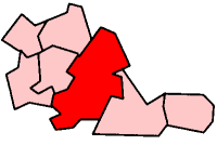
 Edgbaston Edgbaston shown within the West Midlands | |
| Population | 20,749 (2001 Population Census) |
| OS grid reference | SP055845 |
| Metropolitan borough | |
| Metropolitan county | |
| Region | |
| Country | England |
| Sovereign state | United Kingdom |
| Post town | BIRMINGHAM |
| Postcode district | B15 |
| Dialling code | 0121 |
| Police | West Midlands |
| Fire | West Midlands |
| Ambulance | West Midlands |
| EU Parliament | West Midlands |
| UK Parliament | |

Edgbaston is an affluent suburban area of central Birmingham, England, curved around the southwest of the city centre.[1] It is bordered by Moseley to the south east and by Smethwick and Winson Green to the north west.
In the 19th century, the area was under the control of the Gough-Calthorpe family and the Gillott family who refused to allow factories or warehouses to be built in Edgbaston, thus making it attractive for the wealthier residents of the city. Thus it was known as "where the trees begin". Edgbaston is home to Edgbaston Cricket Ground, a Test match venue, the University of Birmingham, established as Birmingham Medical School in 1825, eight out of the nine independent schools within the city, Edgbaston Golf Club, one of the most exclusive private members clubs in the Midlands, as well as the Priory Club, which boasts world class sporting facilities.
In addition, the area also boasts the Birmingham Botanical Gardens as well as the Edgbaston Archery and Lawn Tennis Society, which is the oldest lawn tennis club in the world that is still in use today. The first game of lawn tennis was incidentally also played in Edgbaston, in a garden of a house known as "Fairlawn".
The area is also home to a Michelin star restaurant, Simpsons, as well as a host of renowned pubs such as The Highfield, The Physician and the Edgbaston.
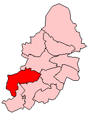
The parliamentary constituency of Edgbaston includes the smaller Edgbaston ward and the wards of Bartley Green, Harborne and Quinton. Edgbaston is also a local government district, managed by its own district committee.
Etymology
Edgbaston means "village of a man called Ecgbald", from the Old English personal name + tun "farm". The personal name Ecgbald means "bold sword" (literally "bold edge"). The name was recorded as a village known as Celboldistane in the Hundred of Coleshill in the 1086 Domesday Book[2] until at least 1139, wrongly suggesting that Old English stān "stone, rock" is the final element of the name.
Demography
.jpg)
In 1801, Edgbaston had a population of around 1,000 people. By 1841, this had increased to 16,500 as a result of wealthy manufacturers moving to the area. By 1850, 29 roads had been laid out and uninterrupted growth continued.[3]
The United Kingdom Census 2001 found that 20,749 people were living in the Birmingham City Council ward of Edgbaston, in 8,666 households. This produced an average of 2.4 people per household, slightly below the citywide average of 2.5. The ward, which has an area of 871.6ha, had a population density of 23.8 people per hectare. Like the city of Birmingham, Edgbaston had a slightly higher proportion of females, at 50.1%, to males. 27.1% of the population was in the 25–44 age bracket and 15.1% were aged between 45–59. At 14.8%, Edgbaston had a lower proportion of people of a pensionable age than the rest of Birmingham (16.7%). It also had a lower proportion of people of working age at 73.8%, although it was above the national percentage of 61.5%.[4]
Edgbaston has a slightly above average percentage for ethnic minorities with ethnic minorities representing 31.8% of the population as opposed to 29.6% for Birmingham. The largest ethnic minority group was the British Asian group at 16.1%. 25.6% of people were born outside of the United Kingdom, above the Birmingham figure of 16.5%. Christianity was the predominant religion, with 52.5% of the population stating that they were Christians, compared with 59.1% for Birmingham. 8.0% stated that they were Muslims, below the Birmingham figure of 14.3%. Edgbaston was home to a significant Orthodox Jewish community. 19.1% of the Edgbaston population stated that they had no religion.[4]
46.4% of households were owner-occupied, below the Birmingham figure of 60.4%. 19.3% were rented privately, 15.2% were rented from a housing association and 11.6% were rented from Birmingham City Council. There was a total number of 9,191 houses in Edgbaston, 525 of which were vacant. At 45.6%, the largest proportion of houses in Edgbaston were purpose-built blocks of flats. This is much higher than the city average of 17.9%. Detached houses were the second most common housing type in the ward at 19.7%.[4]
Edgbaston had an unemployment rate of 8.1%, below the city average of 9.5% although above the national average of 5%. 13.4% of the population stated themselves as students. Of the unemployed, 42% were in long term unemployment and 15.6% had never worked. At 24.6%, the majority of the population worked in finance, real estate, and business activities.[4] The largest employer in the area was the Heart of Birmingham Primary Care Trust, employing 10,000 people.[5]
The Edgbaston Parliamentary Constituency has a much higher population.
Sport
Warwickshire County Cricket Club is based at the Edgbaston Cricket Ground, the area historically being part of Warwickshire. As well as hosting regular county matches, the ground plays host to the England cricket team during one day internationals and test matches.
The area also has a world class tennis venue; The Edgbaston Priory Club. The DFS Classic for female players has been held there every year since 1982 and some of the world's top players participate. The tournament is part of the WTA Tour and wins count towards world rankings. The oldest lawn tennis club in the world, the Edgbaston Archery and Lawn Tennis Society, founded in 1860 is nearby.[6]
There is also a members-only golf course which offers views over the southern part of the suburb. Edgbaston Croquet Club has been located in the area since 1915.[7]
Places of interest
The Church of England parish churches are St Augustine's Church, St Germain's Church, St. George's Church and St. Bartholomew's Church, also known as Edgbaston Old Church.[8] Birmingham Central Synagogue built in 1961 is also in Edgbaston. The Roman Catholic church of the Birmingham Oratory, on Hagley Road, was built in 1907 in the Baroque style as a memorial to John Henry Newman, who founded the English Oratory here. Its dome is a prominent landmark.
J. R. R. Tolkien lived in Edgbaston during his teenage years, and the two towers of Edgbaston, Perrott's Folly and the Waterworks Tower, both close to the Oratory, are said to have provided inspiration for part of his The Lord of the Rings novel. The Barber Institute of Fine Arts, which is located on the University of Birmingham campus, is a purpose built gallery which contains a wide range of art from the masters to Picasso.
Edgbaston Reservoir, formerly known as Rotton Park Reservoir, provides a header supply for the Birmingham Canal Navigations and is an important inner city leisure amenity. There are three public gardens located within Edgbaston; the Birmingham Botanical Gardens and the lesser known University of Birmingham Winterbourne Botanic Garden and Martineau Gardens. Adjoining the university gardens is Edgbaston Pool (not to be confused with the reservoir) which is a Site of Special Scientific Interest. Deer's Leap Wood is a Site of Local Importance for Nature Conservation in the former Mitchells & Butlers (brewery) land in the north part of Edgbaston. Edgbaston contains the only Grade I listed domestic building in Birmingham, notably one of the Arts & Crafts houses number 21 Yateley Road, designed by Herbert Tudor Buckland, and built for his own use. Edgbaston Hall, a Grade II listed country hall, is located within the ward. It is currently the clubhouse for Edgbaston Golf Club.
The BBC opened television studios at Pebble Mill in 1971, which were in use for 33 years until closing in October 2004 and being demolished the following year. The site remains vacant, despite plans upon its closure for a science and technology park to be developed there.[9]
Politics
Birmingham Edgbaston is a constituency, and its Member of Parliament (MP) is Labour's Preet Gill.
The Edgbaston ward of Birmingham City Council is represented by three Conservative councillors, including Deirdre Alden, who unsuccessfully challenged Gisela Stuart in the 2005 general election and 2010 election. Of the other wards of the Edgbaston constituency, Bartley Green is represented by three Conservative councillors, Harborne by one Conservative and two Labour councillors, and Quinton by three Labour councillors.
The constituency has sent a female candidate to Parliament for the past 54 years. Previous MPs included Prime Minister Neville Chamberlain, who was born in Edgbaston.
Education
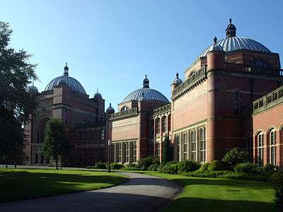
Since the beginning of the 20th century, Edgbaston has been home to the main campus of the University of Birmingham and to Edgbaston High School for Girls, St Paul's School for Girls, St George's School, King Edward's School, King Edward VI Five Ways School, King Edward VI High School for Girls and Priory School. Because of this, there are numerous university halls of residence in the area. At the centre of the university can be found the Joseph Chamberlain Memorial Clock Tower, one of Birmingham's tallest buildings.
Edgbaston is also the home of Queen's College, an ecumenical theological college. West House School, independent primary schools Birmingham Blue Coat School and Hallfield School [ St Swithun's School ] are also located in the area. The Elmhurst School for Dance, the oldest vocational dance school in the United Kingdom, relocated to a new building in Edgbaston in 2004. St Philip's Grammar School used to be located adjacent to the Oratory. However, it became a sixth form college in 1976 and then merged with South Birmingham College in 1995.
Transport and amenities
Two railway stations serve the area. The first, University station, is found in south Edgbaston, west of Birmingham University. The second is Five Ways railway station in the north of the ward on the city's Middle Ring Road. Both stations are on the Cross-City Line. Between these two stations used to be another; Somerset Road station. However, this was closed and demolished some years ago.
The A38 road (Bristol Road) runs through the ward and is one of the main traffic arteries of the city reaching out to the south west of the city and beyond from the city centre and New Street. Along this route buses frequently stop. There are several other bus routes throughout. The Worcester and Birmingham Canal passes through the area, connecting the city centre with the River Severn at Worcester. This was constructed and opened in the 1790s and is used mainly for leisure and recreational purposes as opposed to its originally intended industrial usage.
The A456 road (Hagley Road) runs through the north of Edgbaston and gives a relatively swift link with the city centre as well as faraway places including Halesowen, Kidderminster and Hereford.
The nearest public libraries to the area are in Harborne, Selly Oak and Balsall Heath, whilst the University of Birmingham main library (which members of the public can join for a fee) is in the area. There are a number medical facilities in the area, with two of the most well known being the University Medical Centre and the Calthorpe clinic. Two hospitals are nearby, the Queen Elizabeth Hospital and Selly Oak Hospital.
Future tram halt
Edgbaston tram stop is projected as the Midland Metro system is extended.[10][11][12]
Famous residents
Here is a list of notable residents, many of whom have had Blue Plaques erected on their former houses by The Birmingham Civic Society
- Annette Badland actress
- Sir Gilbert Barling lived a Blythe Court, Norfolk Road and moved to 6 Manor Road after the death of his wife.
- Dr Rosslyn Bruce lived at 4 Manor Road between 1912–1923.
- Dame Barbara Cartland was born in Edgbaston, at 31 Augustus Road.
- Sir Austen Chamberlain Foreign Secretary and Nobel Peace Prize-winner lived at 83 Harborne Road
- Neville Chamberlain (1869–1940) Former British Prime Minister, was born in a house called Southborne, in Edgbaston.
- Oscar Deutsch lived at 8 Rotton Park Road
- Charles Geach MP, founder of the Midland Bank, lived in Wheeleys Hill (now Wheeleys Road)[13]
- William Haywood (architect) lived at 245 Bristol Road (house now demolished)
- Sir Rowland Hill (postal reformer) lived at 146 Hagley Road (house now demolished)
- Sir John Jaffray founder of the Birmingham Daily Post and Birmingham Mail lived at 249 Bristol Road
- Major Arthur Keen MC (1895–1918) World War I flying ace lived in Edgbaston until his military service.[14]
- Celia Levetus (1874–1936), illustrator
- Sir Oliver Lodge lived at Westbourne Road (house now demolished)
- Pink Floyd drummer Nick Mason was born in Edgbaston.
- Constance Naden lived most of her life at Pakenham House, Edgbaston.
- John Henry Newman lived at the Birmingham Oratory, Hagley Road
- Eugene W. Oates Ornithologist[15]
- John Henry Poynting lived at 11 St Augustine's Road
- William Slim, 1st Viscount Slim lived in Poplar Avenue, B 17.
- Joseph Sturge lived at Wheeleys Road (house now demolished)
- J.R.R. Tolkien also lived there for a period during his younger life, with Perrot's Folly and the Edgbaston Waterworks supposedly providing him with the inspiration behind The Two Towers.
- Dr William Withering lived at Edgbaston Hall
- Science fiction author John Wyndham was born there in 1903 and lived at 239 Hagley Road (now demolished) until 1911 when his parents divorced.
- Francis Brett Young lived at 105 Harborne Road
References
- ↑ Tom Dyckhoff. "Let's move to Edgbaston, Birmingham". The Guardian. The Guardian. Archived from the original on 2 August 2017. Retrieved 9 July 2017.
- ↑ "Archived copy". Archived from the original on 21 October 2016. Retrieved 26 July 2015. Open Domesday Map: Edgbaston
- ↑ Davidoff, Leonore; Catherine Hall (2002). Family Fortunes: Men and Women of the English Middle Class, 1780–1850. Routledge. p. 369. ISBN 0-415-21064-X.
- 1 2 3 4 "2001 Population Census in Birmingham: Ward Profiles". Birmingham City Council. 2001. Archived from the original (pdf) on 12 March 2008. Retrieved 2008-03-28.
- ↑ "Edgbaston" (pdf). Birmingham Economy. February 2007. Retrieved 2008-03-28.
- ↑ "The Archery - Edgbaston Archery and Lawn Tennis Society, Edgbaston, Birmingham". www.ealts.net. Archived from the original on 11 September 2017. Retrieved 30 April 2018.
- ↑ "Edgbaston Croquet Club". Edgbaston Croquet Club. Archived from the original on 17 May 2008. Retrieved 28 March 2008.
- ↑ "Archived copy". Archived from the original on 8 July 2009. Retrieved 27 June 2009. St. Bartholomew's Church, Edgbaston: History
- ↑ "Birmingham Roundabout - BBC Pebble Mill – Edgbaston". www.birminghamroundabout.co.uk. Archived from the original on 25 March 2016. Retrieved 30 April 2018.
- ↑ "Midland Metro Grand Central extension opens". British Trams Online. Archived from the original on 9 August 2016. Retrieved 10 June 2016.
- ↑ "Birmingham New Street tram extension opens". Rail News. Archived from the original on 4 June 2016. Retrieved 10 June 2016.
- ↑ "Archived copy" (PDF). Archived from the original (PDF) on 29 July 2014. Retrieved 21 July 2016.
- ↑ Edwards, E. (1887). Personal recollections of Birmingham and Birmingham men. Birmingham: Midland Educational Trading Company Limited. Retrieved 18 August 2015.
- ↑ "Archived copy". Archived from the original on 14 June 2011. Retrieved 15 November 2010. Retrieved on 8 June 2010.
- ↑ Lockyer, Sir Norman (30 April 2018). "Nature". Macmillan Journals Limited. Retrieved 30 April 2018 – via Google Books.
Further reading
- Canon Doctor Terry Slater, 2002, Edgbaston Past, Phillimore, Chichester
External links
- Birmingham City Council: Edgbaston Constituency
- Birmingham City Council: Edgbaston Ward
- Calthorpe Estates
- Edgbaston Mill
- Edgbaston in the Domesday Book
- Profile: Edgbaston
Birmingham council constituencies and wards | ||
| Edgbaston |  | |
| Erdington | ||
| Hall Green | ||
| Hodge Hill | ||
| Ladywood | ||
| Northfield | ||
| Perry Barr | ||
| Selly Oak | ||
| Sutton Coldfield | ||
| Yardley | ||