List of police stations in the West Midlands
Most police stations in the West Midlands county of England are now operated by the West Midlands Police, created on 1 April 1974, but many were built for its predecessors, and some of those closed before its creation. A number of the stations are listed buildings and others are locally listed by the relevant local authority. A few are operated by the British Transport Police.
This list also includes administrative buildings which do not have facilities for the visiting public.
Birmingham
Before 1974, police stations in Birmingham were operated by Birmingham City Police. However, over the years, Birmingham has absorbed land from Staffordshire and Worcestershire, and with it came police staff and stations.
| Name | Location | Completed | Geo-coordinates | Notes | Designation | Image | Ref. |
|---|---|---|---|---|---|---|---|
| Acocks Green police station | 21 Yardley Road, Acocks Green | 1909 | 52°27′02″N 1°49′09″W / 52.4505°N 1.8193°W | Built for Yardley Rural District Council, when Acocks Green was in Worcestershire. Decorated with a "three pears" motif from the Worcestershire coat of arms. The station maybe sold off | Locally listed at 'Grade B' | 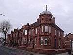 | [1][2] |
| Aston police station | Queen's Road, Aston | 52°30′22″N 1°52′36″W / 52.5061°N 1.8767°W | .jpg) | ||||
| Balsall Heath police station | Edward Road, Balsall Heath | 1869 | 52°27′25″N 1°53′18″W / 52.457076°N 1.888265°W | This station maybe closed and sold off | .jpg) | [3] | |
| Billesley police station | Yardley Wood Road, Billesley | 52°25′54″N 1°52′10″W / 52.431548°N 1.869503°W | .jpg) | ||||
| Bordesley Green police station | 282 Bordesley Green | 52°28′39″N 1°51′03″W / 52.477588°N 1.850719°W | This is now Heartland Hostel. The police station closed down by 2010. | 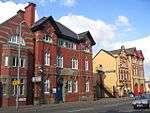 | [4] | ||
| Bournville police station | Bournville Lane, Bournville | 52°25′46″N 1°56′59″W / 52.429357°N 1.949799°W | Near the Bristol Road South between Selly Oak and Northfield | .jpg) | |||
| Canterbury Road police station | Canterbury Road, Perry Barr | 1904 | 52°30′45″N 1°54′05″W / 52.5126°N 1.9015°W | Closed; put up for sale October 2013 | Locally listed at 'Grade A' | 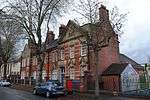 | [5] |
| Castle Vale police station | 44 High Street, Castle Vale | 52°31′17″N 1°47′01″W / 52.5215°N 1.7837°W | This former police station was up for auction in October 2016 | 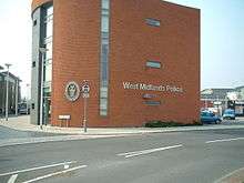 | [6][7] | ||
| Digbeth police station | High Street, Digbeth | 52°28′35″N 1°53′25″W / 52.4764°N 1.8904°W | Built by the Birmingham firm T. Elvins and Sons. Could be closed and sold off. | Locally listed at 'Grade A' | 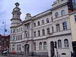 | [8] [3] | |
| Dudley Road police station | Summerfield Park, Summerfield | 52°29′10″N 1°56′16″W / 52.48625°N 1.93771°W | Disused; at risk | 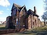 | [9] | ||
| Edgbaston police station | Belgrave Middleway, Edgbaston | 52°27′59″N 1°53′57″W / 52.4663°N 1.8991°W | .jpg) | ||||
| Erdington police station | Wilton Road, Erdington | 52°31′34″N 1°50′21″W / 52.5261°N 1.8391°W |  | [6] | |||
| Handsworth West police station | Holyhead Road, Handsworth | 52°30′21″N 1°56′50″W / 52.5059°N 1.9473°W | | [10] | |||
| Harborne police station | Rose Road, Harborne | 52°27′43″N 1°56′54″W / 52.462060°N 1.948436°W | Not open to the public. Could be closed and sold off. | | [3] | ||
| Hay Mills police station | Coventry Road, Yardley | 52°27′46″N 1°49′26″W / 52.4627°N 1.8240°W | Now a pub, 'The Old Bill and Bull'. | .jpg) | |||
| Jewellery Quarter police station | Golden Square, Warstone Lane, Hockley | 52°29′15″N 1°54′40″W / 52.4876°N 1.9111°W | Located in what is now Golden Square. | .jpg) | [10] | ||
| Kenyon Street police station | Kenyon Street, Hockley | 52°29′15″N 1°54′40″W / 52.4876°N 1.9111°W | Closed 1972; demolished. | | [11] | ||
| King Heath police station | 1 High Street, Kings Heath | 52°26′17″N 1°53′36″W / 52.4381°N 1.8932°W | .jpg) | [1] | |||
| Kingstanding police station | 840 Kingstanding Road, Kingstanding | 52°33′15″N 1°53′05″W / 52.5542°N 1.8846°W | This station maybe closed and sold off | 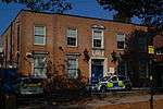 | [6][3] | ||
| Kings Norton police station | High Meadow Road, Kings Norton | 52°24′26″N 1°55′35″W / 52.407293°N 1.926419°W |  | ||||
| Ladywood police station | Ladywood Middleway, Ladywood | 52°28′34″N 1°55′30″W / 52.4760°N 1.9251°W | Replaced an earlier station, nearby | | |||
| Lloyd House, Birmingham | Snow Hill Queensway at Colmore Circus Queensway | 1964 | 52°29′02″N 1°53′51″W / 52.4839°N 1.8975°W | Force headquarters and now a police station from 2016, since Steelhouse Lane police station closed in early 2017. Refurbished in 2015-16. | 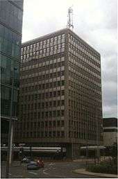 | ||
| Longbridge police station | Bristol Road South, Northfield | 52°24′17″N 1°58′43″W / 52.404845°N 1.978562°W | The former police station was sold at auction and will be converted into offices on the ground floor and apartments above. | _(2).jpg) | [12] | ||
| Moseley police station | Woodbridge Road, Moseley | 52°26′54″N 1°53′13″W / 52.448468°N 1.886854°W | .jpg) | ||||
| Nechells police station | Fowler Street, Nechells | 52°29′41″N 1°52′13″W / 52.4946°N 1.8704°W | | [10] | |||
| Newtown police station | 204 Bridge Street West, Newtown | 52°29′37″N 1°53′58″W / 52.4937°N 1.8994°W | Locally listed at 'Grade B' | | [10] | ||
| Perry Barr police station | 394 Walsall Road, Perry Barr | 52°31′45″N 1°54′40″W / 52.5293°N 1.9112°W | Sold September 2017 to the Great Barr Muslim Foundation, for conversion to a community centre. | 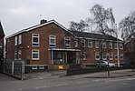 | [10][13] | ||
| Quinton police station | 300 Quinton Road, Quinton | 52°27′13″N 1°59′48″W / 52.453719°N 1.996770°W | Not open to the public. Could be closed and sold off | | [3] | ||
| Shard End police station | 169 Packington Avenue, Shard End | 52°29′39″N 1°46′18″W / 52.494140°N 1.771609°W | The station maybe sold off | | [3] | ||
| Sheldon police station | Sheldon Heath Road, Sheldon | 52°28′14″N 1°47′04″W / 52.470581°N 1.784480°W | It is in Garretts Green | .jpg) | |||
| Sparkbrook Police Outpost | Stratford Road, Sparkbrook | 52°27′45″N 1°52′31″W / 52.462524°N 1.875377°W | Was at the site from at least 2009 to 2012. Replaced by an estate agent and later a barber shop | | |||
| Sparkhill police station | Stratford Road, Sparkhill | 52°27′02″N 1°51′53″W / 52.4506°N 1.8646°W | Houses West Midlands Police Museum | Locally listed at 'Grade B' | 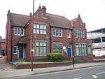 | [10] | |
| Stechford police station | 338 Station Road, Stechford | 52°28′42″N 1°48′26″W / 52.4784°N 1.8071°W | | [1] | |||
| Steelhouse Lane police station | Steelhouse Lane, Birmingham | 1933 | 52°29′03″N 1°53′36″W / 52.4843°N 1.8934°W | AKA Birmingham Central police station. The cell block is an older, Victorian building. The station closed permanently on Sunday 15 January 2017. | 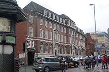 | [14][15] [16] | |
| Summerfield police station | Icknield Port Road, Summerfield | 52°29′10″N 1°56′12″W / 52.486124°N 1.936663°W | The station moved from its old building on Dudley Road, near Summerfield Park | | |||
| Sutton Coldfield police station | Lichfield Road, Sutton Coldfield | 52°34′05″N 1°49′25″W / 52.5680°N 1.8237°W | Maybe closed and sold off. Could be replaced with contact office | | [6] [3] | ||
| Thornhill Road police station | Handsworth | 1878 | 52°30′13″N 1°55′42″W / 52.5037°N 1.9284°W | aka Handsworth police station. Built at the same time as the nearby library and town hall. Originally in Staffordshire; includes a courthouse. Could be closed and sold off. | | [10][17][3] | |
| West Midlands Police - Learning & Development Centre | Pershore Road, Edgbaston | 52°27′15″N 1°54′26″W / 52.454093°N 1.907280°W | Also known as Tally Ho Police Training | |
Coventry
| Name | Location | Completed | Geo-coordinates | Notes | Designation | Image | Ref. |
|---|---|---|---|---|---|---|---|
| Coventry Central police station | Little Park Street, Coventry | 52°24′17″N 1°30′30″W / 52.404610°N 1.508298°W | 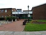 | ||||
| Canley police station | Sir Henry Parkes Road, Canley | 52°23′36″N 1°33′06″W / 52.393432°N 1.551631°W | May close and be sold off | | [3] | ||
| Foleshill police station | Stoney Stanton Road, Foleshill | 52°25′33″N 1°29′41″W / 52.425925°N 1.494657°W | May close and be sold off | | [3] | ||
| Willenhall police station | Chace Avenue, Willenhall | 52°23′12″N 1°28′19″W / 52.386677°N 1.472071°W | May close and be sold off | | [3] |
Dudley
Dudley's stations were originally operated by Dudley Borough Police, then from 1 April 1966 until 31 March 1974, by West Midlands Constabulary.
| Name | Location | Completed | Geo-coordinates | Notes | Designation | Image | Ref. |
|---|---|---|---|---|---|---|---|
| Brierley Hill Police Station | Bank Street, Brierley Hill | 52°29′02″N 2°07′21″W / 52.483795°N 2.122546°W | Part of Civic Hall complex | 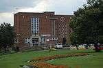 | |||
| Dudley Police Station | New Street, Dudley | 52°30′43″N 2°04′59″W / 52.511855°N 2.082954°W | 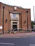 | ||||
| Sedgley police station | Vicar Street, Sedgley | 52°32′25″N 2°07′25″W / 52.540172°N 2.123697°W | May close and be sold off |  | [3] | ||
| Stourbridge police station | New Road, Stourbridge | 1885 | 52°27′17″N 2°08′42″W / 52.454715°N 2.145071°W | Built as the County Police station, it replaced an earlier court and jail on the site. | .jpg) |
Sandwell
Before 1974, police stations in Sandwell were operated by Staffordshire Police.
| Name | Location | Completed | Geo-coordinates | Notes | Designation | Image | Ref. |
|---|---|---|---|---|---|---|---|
| Court of Requests | Church Street, Oldbury | 1816 | 52°30′17″N 2°00′57″W / 52.504693°N 2.015808°W | former police station & court; now J D Wetherspoon pub, "Court of Requests" | Grade II listed | 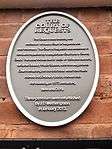 | [18] |
| Oldbury police station | 86 Birmingham Street (Oldbury Ringway), Oldbury | 52°30′08″N 2°00′45″W / 52.502260°N 2.012451°W | May close and be sold off | .jpg) | [3] | ||
| Smethwick police station | Piddock Road, Smethwick | 52°29′38″N 1°58′02″W / 52.493790°N 1.967288°W | Also known as South Sandwell Police Station. May close and be sold off | | [3] | ||
| Tipton police station | Lower Church Lane, Tipton | 52°31′45″N 2°03′06″W / 52.529219°N 2.051571°W | May close and be sold off | | [3] | ||
| Wednesbury police station | Holyhead Road, Wednesbury | 52°33′03″N 2°01′23″W / 52.55084°N 2.022997°W | May close and be sold off | 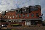 | [3] | ||
| West Bromwich Police Station | Oak Road and Price Street, West Bromwich | 2011 | 52°31′02″N 1°59′54″W / 52.517262°N 1.998399°W | .jpg) |
Solihull
| Name | Location | Completed | Geo-coordinates | Notes | Designation | Image | Ref. |
|---|---|---|---|---|---|---|---|
| Shirley police station | Stratford Road, Shirley | 52°24′33″N 1°49′31″W / 52.4093°N 1.8252°W | As of 2017 the police station has closed down and is for sale. It closed down in 2015. | .jpg) | [19] | ||
| Solihull police station | Homer Road, Solihull | 52°24′44″N 1°46′51″W / 52.4122°N 1.7807°W | May close and be replaced by a contact office | 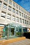 | [3] | ||
| Chelmsley Wood police station - The Walk-in Centre | Ceolmund Crescent, Chelmsley Wood | 52°28′52″N 1°44′29″W / 52.481018°N 1.741373°W | 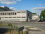 |
Walsall
Walsall's stations were originally operated by Walsall Borough Police, then from 1 April 1966 until 31 March 1974, by West Midlands Constabulary.
| Name | Location | Completed | Geo-coordinates | Notes | Designation | Image | Ref. |
|---|---|---|---|---|---|---|---|
| Aldridge police station | 1-3 Anchor Parade, Aldridge | 52°36′14″N 1°55′05″W / 52.603790°N 1.918109°W | May close and be sold off | | [3] | ||
| Brownhills police station | 25 Chester Road North, Brownhills | 52°38′59″N 1°56′16″W / 52.649771°N 1.937684°W | 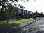 | ||||
| Bloxwich police station | 1 Station Street, Bloxwich | 52°36′52″N 2°00′20″W / 52.614536°N 2.005571°W | | ||||
| Darlaston police station | Crescent Roadd, Darlaston | 52°34′06″N 2°02′00″W / 52.568219°N 2.033444°W | 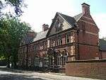 | ||||
| Former Walsall police station | Goodall Street, Walsall | 1866 | 52°35′00″N 1°58′43″W / 52.583251°N 1.978722°W | It's now Sofia's Restaurant | .jpg) | ||
| Leamore Police Outpost | Stephenson Avenue, Leamore | 52°36′06″N 2°00′27″W / 52.601580°N 2.007542°W | Was next to the BCHA centre. Closed down by 2017. | 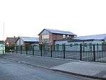 | |||
| Walsall police station | Green Lane, Walsall | 52°35′20″N 1°59′12″W / 52.588986°N 1.986687°W | Closed down in 2016 | |
Wolverhampton
Wolverhampton's stations were originally operated by Wolverhampton Borough Police, then from 1 April 1966 until 31 March 1974, by West Midlands Constabulary.
| Name | Location | Completed | Geo-coordinates | Notes | Designation | Image | Ref. |
|---|---|---|---|---|---|---|---|
| Bilston police station | Mount Pleasant, Bilston | 52°34′02″N 2°04′26″W / 52.567349°N 2.073991°W | Closed down | 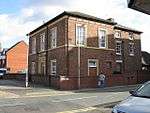 | |||
| Low Hill Police Base | 147 Fifth Avenue, Low Hill | 52°36′28″N 2°07′01″W / 52.607859°N 2.117025°W | |
| |||
| Tettenhall police station | 30 High Street, Tettenhall | 52°35′51″N 2°10′06″W / 52.597400°N 2.168415°W | 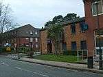 | ||||
| Wednesfield police station | Alfred Squire Road, Wednesfield | 52°35′56″N 2°04′51″W / 52.598884°N 2.080726°W | May close and be sold off | 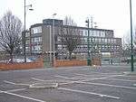 | [3] | ||
| Willenhall police station | John Street, Willenhall | 52°35′02″N 2°03′12″W / 52.583853°N 2.053227°W | | ||||
| Wolverhampton Central police station | Metro One Campus, Bilston Street, Wolverhampton | 52°35′04″N 2°07′28″W / 52.584306°N 2.124538°W | _-_geograph.org.uk_-_392070.jpg) |
References
| Wikimedia Commons has media related to Police stations in the West Midlands. |
- 1 2 3 "Contact us - Birmingham East". West Midlands Police. Retrieved 27 March 2014.
- ↑ "Local list". Acocks Green History Society: new website. Retrieved 27 March 2014.
- 1 2 3 4 5 6 7 8 9 10 11 12 13 14 15 16 17 18 19 20 "MPs vow to fight police station closures after West Midlands Police Commissioner says 24 will go". Birmingham Mail. Retrieved 19 February 2018.
- ↑ "Bordesley Green hostel plan sparks protests". Birmingham Mail. Retrieved 26 January 2017.
- ↑ "Disposal of Property Decision (Draft)" (PDF). West Midlands Police and Crime Commissioner. Retrieved 27 March 2014.
- 1 2 3 4 "Your Local Police - Birmingham North". West Midlands Police. Retrieved 27 March 2014.
- ↑ "Fancy a night in the cells? Cop shop goes on the market". Birmingham Mail. Retrieved 11 September 2017.
- ↑ Chinn, Carl (2000). Brum and Brummies. Brewin Books. p. 87. ISBN 1858581818.
- ↑ Jones, Tamlyn (29 June 2016). "Nine treasured West Midlands buildings at risk of being lost forever". Birmingham Post. Retrieved 10 July 2016.
- 1 2 3 4 5 6 7 "Your Local Police - Birmingham West and Central". West Midlands Police. Retrieved 27 March 2014.
- ↑ Haddleton, Marie E; Sergeant Gordon Tracey (2007-09-24). "Kenyon Street Police Station". The Hockley Flyer. Retrieved 26 March 2014.
- ↑ "Planning application submitted for former Longbridge Police Station". B31 Voices. 2018-02-17. Retrieved 17 February 2018.
- ↑ Hussain, Danny (7 September 2017). "Former police station being turned into Muslim community centre". birminghammail. Retrieved 11 September 2017.
- ↑ Goer, Matthew (14 August 2007). Steelhouse Lane Conservation Area Character Appraisal (PDF). Birmingham City Council. Retrieved 24 March 2014.
- ↑ "Birmingham's Hidden Spaces: What future for Steelhouse Lane's 'mini-prison'?". Birmingham Post. Retrieved 24 March 2014.
- ↑ "Steelhouse Lane police station closes for final time". bbc.co.uk/news. Retrieved 16 January 2017.
- ↑ "Thornhill Road Police Station (Formerly Staffordshire Court)". Legacy-WM. Retrieved 27 March 2014.
- ↑ "Oldbury Public Library A Grade II Listed Building in Oldbury, Sandwell". British Listed Buildings. Retrieved 18 March 2017.
- ↑ "Shirley Police station set to close". Solihull Observer. Retrieved 6 October 2017.