List of lighthouses in Papua New Guinea
This is a list of lighthouses in Papua New Guinea.[1][2][3]
Lighthouses
| Name | Image | Year built | Location & coordinates | Class of Light | Focal height | NGA number | Admiralty number | Range nml |
|---|---|---|---|---|---|---|---|---|
| Abligini Island Lighthouse | n/a | New Britain 6°18′20.3″S 150°04′33.0″E / 6.305639°S 150.075833°E | Fl W 10s. | 103 metres (338 ft) | 10890 | K3506.5 | 10 | |
| Adele Island Lighthouse | n/a | Louisiade Archipelago 11°26′53.7″S 154°23′51.7″E / 11.448250°S 154.397694°E | Fl W 8s. | 43 metres (141 ft) | 26284 | K3450.5 | 16 | |
| Alim Island Lighthouse | n/a | Admiralty Islands 2°53′39.5″S 147°03′26.1″E / 2.894306°S 147.057250°E | Fl W 5s. | 32 metres (105 ft) | 10928 | K3476 | 10 | |
| Ava Point Lighthouse | n/a | Morobe Province 10°34′10.8″S 149°52′47.2″E / 10.569667°S 149.879778°E | Fl W 12s. | 188 metres (617 ft) | 26320 | K3456.5 | 10 | |
| Basilisk Passage Lighthouse | Image | n/a | Port Moresby 9°32′20.2″S 147°08′02.1″E / 9.538944°S 147.133917°E | Fl W 5s. | 9 metres (30 ft) | 26352 | K3458 | 10 |
| Basilisk Passage Range Front Lighthouse | n/a | Port Moresby 9°29′53.3″S 147°11′06.2″E / 9.498139°S 147.185056°E | Oc W 4s. | 38 metres (125 ft) | 26360 | K3459 | 18 | |
| Basilisk Passage Range Rear Lighthouse | n/a | Port Moresby 9°29′47.3″S 147°11′19.3″E / 9.496472°S 147.188694°E | Oc W 6s. | 90 metres (300 ft) | 26364 | K3459.1 | 10 | |
| Boera Head Lightouse | Image | n/a | Port Moresby 9°23′22.9″S 147°00′51.1″E / 9.389694°S 147.014194°E | Fl W 2.5s. | 33 metres (108 ft) | 26392 | K3563.8 | 10 |
| Bomatu Point Lighthouse | n/a | Trobriand Islands 8°24′19.9″S 151°06′46.5″E / 8.405528°S 151.112917°E | Fl (3) W 15s. | 31 metres (102 ft) | 26416 | K3436 | 10 | |
| Bonarua Island Lighthouse | n/a | Bonarua Hili Hili Island 10°45′18.0″S 150°22′54.0″E / 10.755000°S 150.381667°E (NGA) | Fl (3) W 15s. | 209 metres (686 ft) | 26316 | K3456 | 10 | |
| Bright Island Lighthouse | n/a | Engineer Islands 10°32′01.2″S 151°12′45.5″E / 10.533667°S 151.212639°E | Fl W 2.5s. | 16 metres (52 ft) | 26292 | K3444 | 10 | |
| Cape Concordia Lighthouse | n/a | Vanimo 2°40′22.6″S 141°18′15.8″E / 2.672944°S 141.304389°E | Fl W 5s. | 68 metres (223 ft) | 26130 | K3400 | 10 | |
| Cape Cretin Lighthouse | n/a | Nussing Island ~6°39′20.1″S 147°51′34.0″E / 6.655583°S 147.859444°E | Fl W 6s. | 21 metres (69 ft) | 26188 | K3406 | 10 | |
| Cape Croisilles | n/a | Madang Province 4°50′51.8″S 145°48′17.1″E / 4.847722°S 145.804750°E | Fl (2) W 6s. | 22 metres (72 ft) | 26160 | K3401.8 | 10 | |
| Cape Gerhard | n/a | Morobe Province 6°44′48.7″S 147°34′37.9″E / 6.746861°S 147.577194°E | Fl (3) W 12s. | 22 metres (72 ft) | 26192 | K3408 | 10 | |
| Cape Gourdon Lighthouse | n/a | Madang Province 4°23′09.3″S 145°19′20.0″E / 4.385917°S 145.322222°E | Fl (3) W 9s. | 15 metres (49 ft) | 26156 | K3401.6 | 10 | |
| Cape Hollman | n/a | West New Britain Province 4°59′30.0″S 150°07′18.0″E / 4.991667°S 150.121667°E | Fl W 6s. | 8 metres (26 ft) | 10880 | K3484 | 10 | |
| Cape Lambert Lighthouse | n/a | 4°05′30.0″S 151°31′12.0″E / 4.091667°S 151.520000°E | Fl (3) W 15s. | 20 metres (66 ft) | 10864 | K3492 | 10 | |
| Cape L'Averdy Lighthouse | n/a | Bougainville Island 5°32′29.0″S 155°03′52.8″E / 5.541389°S 155.064667°E | Fl W 6s. | 25 metres (82 ft) | 10824 | K4884 | 15 | |
| Cape Moem Lighthouse | n/a | Wewak 3°33′04.3″S 143°42′07.9″E / 3.551194°S 143.702194°E | Fl G 5s. | 8 metres (26 ft) | 26142 | K3400.6 | 4 | |
| Cape Oxford Lighthouse | n/a | East New Britain Province 5°26′43.5″S 152°05′02.5″E / 5.445417°S 152.084028°E | Fl (3) W 15s. | 94 metres (308 ft) | 10892 | K3506 | 10 | |
| Cape St. George Lighthouse | n/a | New Ireland Province 4°50′54.0″S 152°52′36.0″E / 4.848333°S 152.876667°E | Fl W 5s. | 101 metres (331 ft) | 10896 | K3514 | 10 | |
| Cape Tawui Lighthouse | n/a | New Britain 4°08′09.7″S 152°10′11.6″E / 4.136028°S 152.169889°E | Fl W 7.5s. | 47 metres (154 ft) | 10852 | K3494 | 18 | |
| Coast Watchers Lighthouse | 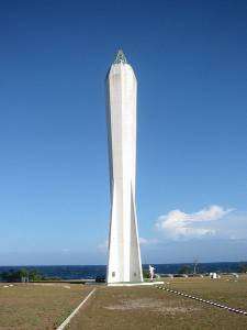 | 1959 | Madang 5°12′44.6″S 145°48′53.4″E / 5.212389°S 145.814833°E | Fl W 15s. | 28 metres (92 ft) | 26172 | K3402 | 12 |
| Condor Point Lighthouse | n/a | Madang Province 4°07′08.2″S 144°51′44.5″E / 4.118944°S 144.862361°E | Fl (2) W 8s. | 15 metres (49 ft) | 26152 | K3401.4 | 10 | |
| Hood Point Lighthouse | Image | n/a | Central Province 10°06′12.0″S 147°43′36.6″E / 10.103333°S 147.726833°E | Q (2) W 8s. | 8 metres (26 ft) | 26348 | K3457 | 10 |
| Hospital Hill Lighthouse | n/a | Arawa 6°13′44.3″S 155°34′22.4″E / 6.228972°S 155.572889°E | Fl W 5s. | 87 metres (285 ft) | 10812 | K4884.5 | n/a | |
| Idihi Island Lighthouse | Image | n/a | Port Moresby 9°25′39.0″S 146°53′00.3″E / 9.427500°S 146.883417°E | Fl (2) W 5s. | 23 metres (75 ft) | 26384 | K3464 | 10 |
| Ipoteto Island Lighthouse | n/a | Morobe Province 9°37′45.2″S 150°01′24.0″E / 9.629222°S 150.023333°E | Fl (2) W 8s. | 23 metres (75 ft) | 26260 | K3432 | 10 | |
| Jomard Islands Lighthouse | n/a | Jomard Islands 11°15′19.1″S 152°08′08.3″E / 11.255306°S 152.135639°E | Fl W 10s. | 24 metres (79 ft) | 26276 | K3450.3 | 10 | |
| Kegawam Island Lighthouse | n/a | Engineer Islands 10°21′13.7″S 151°23′06.6″E / 10.353806°S 151.385167°E | Fl W 6s. | 8 metres (26 ft) | 26264 | K3438 | 10 | |
| Kiau Point Lighthouse | n/a | 5°12′13.3″S 147°05′33.2″E / 5.203694°S 147.092556°E | Fl W 5s. | 23 metres (75 ft) | 10888 | K3478 | 10 | |
| Kimbe Bay No 12 Lighthouse | n/a | Kimbe Bay 5°16′32.0″S 150°57′51.0″E / 5.275556°S 150.964167°E | Fl (2) W 10s. | 13 metres (43 ft) | 10871.7 | K3490.32 | 10 | |
| Kitava Island Lighthouse | n/a | Trobriand Islands 8°38′43.4″S 151°19′52.6″E / 8.645389°S 151.331278°E | Fl W 7.5s. | 107 metres (351 ft) | 26420 | K3437 | 10 | |
| Lunn Island Lighthouse | Image | n/a | Lunn Island 10°47′12.6″S 152°00′26.2″E / 10.786833°S 152.007278°E | Fl W 4s. | 15 metres (49 ft) | 26272 | K3449 | 15 |
| Mait Island Lighthouse | n/a | New Ireland Province 3°00′03.7″S 150°43′35.7″E / 3.001028°S 150.726583°E | Fl W 10s. | 79 metres (259 ft) | 10900 | K3512 | 10 | |
| Madehas Island Lighthouse | n/a | Buka Island 5°27′37.4″S 154°38′03.7″E / 5.460389°S 154.634361°E | Fl W 10s. | 137 metres (449 ft) | 10828 | K4883 | 16 | |
| Oro Bay Range Front Lighthouse | n/a | Oro Province 8°54′10.9″S 148°28′22.6″E / 8.903028°S 148.472944°E | Fl W 3s. | 119 metres (390 ft) | 26220 | K3424 | 18 | |
| Oro Bay Range Rear Lighthouse | n/a | Oro Province 8°54′15.1″S 148°28′14.8″E / 8.904194°S 148.470778°E | Fl W 10s. | 133 metres (436 ft) | 26224 | K3424.1 | 18 | |
| Otua Islet Lighthouse | n/a | Bougainville Island 6°27′31.1″S 155°58′25.9″E / 6.458639°S 155.973861°E | Fl W 5s. | 26 metres (85 ft) | 10788 | K4886 | 14 | |
| Rabaul Range Front Lighthouse | Image | n/a | Rabaul 4°11′56.5″S 150°10′07.6″E / 4.199028°S 150.168778°E | Fl W 2s. | 28 metres (92 ft) | 10844 | K3498 | 10 |
| Rabaul Range Rear Lighthouse | Image | n/a | Rabaul 4°11′42.0″S 150°10′06.0″E / 4.195000°S 150.168333°E (NGA) | Fl W 5s. | 38 metres (125 ft) | 10848 | K3498.1 | 7 |
| Rothery Passage Lighthouse | n/a | Central Province 10°21′04.1″S 148°41′27.8″E / 10.351139°S 148.691056°E | Fl (3) W 15s. | 22 metres (72 ft) | 26344 | K3456.7 | 10 | |
| Seeadler Harbor Lighthouse | Image | n/a | Seeadler Harbor 1°57′37.8″S 147°19′03.5″E / 1.960500°S 147.317639°E | Fl (4) W 16s. | 27 metres (89 ft) | 10916 | K3507 | 10 |
| Spear Island Lighthouse | Image | n/a | Oro Province 8°59′22.4″S 149°08′16.7″E / 8.989556°S 149.137972°E | Fl W 6s. | 19 metres (62 ft) | 26228 | K3426 | 10 |
| Steffan Strait Lighthouse | n/a | New Ireland Province 2°42′29.3″S 150°36′48.6″E / 2.708139°S 150.613500°E | Fl (2) W 8s. | 13 metres (43 ft) | 10904 | K3511 | 10 | |
| Strathord Islands Lighthouse | n/a | Strathord Islands 10°13′19.6″S 151°51′59.4″E / 10.222111°S 151.866500°E | Fl (3) W 12s. | 8 metres (26 ft) | 26296 | K3448 | 10 | |
| Weka Una Rock Lighthouse | Image | n/a | Morobe Province 10°36′10.3″S 150°36′38.2″E / 10.602861°S 150.610611°E | Fl (2) W 8s. | 10 metres (33 ft) | 26324 | K3455 | 10 |
| Yule Island Lighthouse | n/a | Yule Island 8°49′37.5″S 146°32′03.3″E / 8.827083°S 146.534250°E | Fl (3) W 15s. | 54 metres (177 ft) | 26400 | K3465 | 8 | |
See also
References
- ↑ Papua New Guinea The Lighthouse Directory. University of North Carolina at Chapel Hill. Retrieved 26 October 2016
- ↑ List of Lights, Pub. 111: The West Coasts of North and South America (Excluding Continental U.S.A. and Hawaii), Australia, Tasmania, New Zealand, and the Islands of the North and South Pacific Oceans (PDF). List of Lights. United States National Geospatial-Intelligence Agency. Retrieved 26 October 2016
- ↑ List of Lights, Pub. 112: Western Pacific and Indian Oceans Including the Persian Gulf and Red Sea (PDF). List of Lights. United States National Geospatial-Intelligence Agency. Retrieved 26 October 2016
External links
- Rowlett, Russ. "The Lighthouse Directory". University of North Carolina at Chapel Hill.
| Types |
| _-_cropped.jpg) | ||||||
|---|---|---|---|---|---|---|---|---|
| Fixtures | ||||||||
| Maintenance | ||||||||
| Locations | ||||||||
| Categories |
| |||||||
| Global organizations | ||||||||
| ||||||||
This article is issued from
Wikipedia.
The text is licensed under Creative Commons - Attribution - Sharealike.
Additional terms may apply for the media files.