List of disasters in the Philippines
List of disasters in the Philippines:
Astronomical phenomenon
Pre-history
| Event | Date | Cause |
|---|---|---|
| Quaternary extinction event | Pleistocene 640,000, 74,000, and 13,000 years ago | Clovis comet? (13,000 years ago)[1] |
| Pliocene–Pleistocene boundary marine extinction | Pliocene 2 Ma | Supernova in the Scorpius-Centaurus OB association[2] |
Historical era
| Event | Date | Cause |
|---|---|---|
| Meteorite impact (Tablas Island, Romblon) | March 7, 2011 | At about 10am on March 7, 2011 (UTC+8), a loud explosion was heard at the island of Tablas in Romblon province in Central Philippines. It was followed by a tremor.
Fishermen on sea saw a fiery and swift ball of fire falling from sky (daytime).[3] |
Volcanic eruptions
Pre-history
The Ancestral Mount Pinatubo Erupted during pre-history, but it is less-explosive than the modern Mount Pinatubo.

The Mt.Masaraga,The thick lava flows from Holocene period are still present on the flanks of the mountain.
- Most of the Eruption recorded from potentially active Stratovolcano according to dated Lava flows .
| Event | Date | Notes |
|---|---|---|
| Eruption of Mount Panay | Pleistocene | Last eruptive activity is thought to be Pleistocene, about 500,000 years ago.[4] |
| Eruption of Mount Arayat | Holocene | There are no cultural records of historical eruptions. However, weak steaming is currently present in some of the heavily eroded vents on the North Western side of the summit. The ancient eruptions were said to have caused the formation of a Lava Dome on the Western Slopes of the mountain known as White Rock which makes a nice tourist destination and is usually a field trip destination for students of Pampanga Agricultural College. The Arayat amphitheatre is said to have been caused by the summit's collapse on the western side but a much deeper crater is present on the eastern side, it was said that the mountain was once a volcanic island, until eruptions covered the surrounding area with soil, eruptions were said to be the possible cause of a theorized re-route of Pampanga River which is said to have once passed on the western side rather than eastern side where it currently moves[4] |
| Eruption of Mount Natib | Pleistocene or Holocene | There are no historical eruptions within the Natib caldera complex. Studies in 1991 (Panum and Rayem) indicate that the last eruptive activity was probably Holocene to upper Pleistocene. An earlier study in 1971 (Ebasco Services) dated the eruptive products between 69,000 +/- 27,000 years old. |
| Eruption of Mt.Masaraga | Holocene | There are no historical eruptions from the volcano with the last eruptive activity dated as Holocene as reported by the Global Volcanism Program. Thick lava flows from that period are present on the flanks of Mount Masaraga, an understudied volcano in the Philippines. |
| Eruption of Laguna Caldera | C28,000 BP | The caldera, whose lake surface is only 1m above sea level, may have formed by least two major eruptions of about 1 million and 27,000-29,000 years ago.[4] |
| Eruption of Mount Malinao | 60,000 BP | There are no historical eruptions from Malinao which is believed to have been active from about 500,000 years ago until 60,000 years ago.[5] |
| Eruption of Cuernos de Negros | 12,000 BC | An earlier study in 1971 (Ebasco Services) dated the eruptive products between 69,000 +/- 27,000 years old. |
| Eruption of Ancestral Pinatubo | Holocene 1.1 million years ago | The activity of Ancestral Pinatubo seems to have begun about 1.1 million years ago and probably ended tens of thousands or more before the birth of 'Modern Pinatubo'. Much of the rugged land surrounding the present volcano consists of remnants of 'ancestral' Pinatubo. It was an andesite and dacite stratovolcano with its eruptive activity much less explosive than modern Pinatubo. |
| Eruption of Mt.Mariveles | 2050 BCE | There are no recorded historical eruptions from Mariveles caldera, with the last activity indicated by Radiocarbon dating occurring around mid-Holocene or about 2050 BCE.[6] |
Historical era
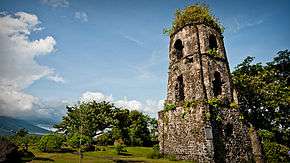
Only the church tower remains of the Cagsawa Church, which was buried by the 1814 eruption of Mayon Volcano.
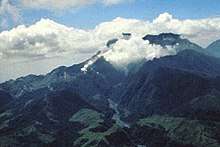
The eruption column of Modern Pinatubo on June 12, 1991, three days before the climactic eruption.

Map of Pinatubo showing nearby peaks and the evacuation zones.
Eruptions have also destroyed numerous lakeside towns, burying them with volcanic ash or submerged them by rising lake waters displaced by the erupted material. Lipa, Taal, Sala, Bauan and Tanauan were formerly located along Taal Lake. Presently, only three towns are on the lake's shore. Remnants of the old lakeside towns are reported to be seen under the lake's waters.[7]
| Event | Date | Notes |
|---|---|---|
| Leonard Kniaseff | c.120 AD.[8] | There was a scare in 1995 but PHIVOLCS investigation at the time did not disclose any unusual activity, and no unusual activity has been reported since. |
| San Pablo Volcanic Field | 1350 AD +/- 100 | Last activity was the formation of Sampaloc Lake around 1350 AD +/- 100 years determined by anthropology[9] |
| Taal Eruption | 1572 to 1977 and 1991 | The series of eruptions create a Caldera Lake for a long time, showing signs of unrest since and permanently monitored. |
| Mayon Eruption | 1616 to 2014 | The most destructive eruption of Mayon occurred on February 1, 1814 (VEI=4). Lava flowed but not as much compared to the 1766 eruption; Instead, the volcano was belching dark ash and eventually bombarded the town of Cagsawa with tephra that buried it. Trees were burned; rivers were certainly damaged. Proximate areas were also devastated by the eruption, with ash accumulating to 9 m (30 ft) in depth. In Albay, a total of 2,200 locals perished in what is considered to be the most lethal eruption in Mayon's history; estimates by PHIVOLCS list the casualties at about 1,200, however. The eruption is believed to have contributed to the accumulation of atmospheric ash, capped by the catastrophic eruption of Mount Tambora in 1815, that led to the Year Without a Summer in 1816. |
| Pinatubo Eruption | 1500 and 1991 | Reawakened in 1990 producing the 2nd largest eruption in the 20th century. Followed by milder eruptions in 1992 and 1993,On July 16, 1990, the major 1990 Luzon earthquake of magnitude 7.7 struck central Luzon. This was the largest earthquake recorded in 1990,[10] |
| Mt.Kanlaon Eruption | 1886 to 2006 | The most active volcano in central Philippines, Kanlaon has erupted 26 times since 1919. Eruptions are typically phreatic explosions of small-to-moderate size that produce minor ash falls near the volcano. In 1902, the eruption was classified as strombolian, typified by the ejection of incandescent cinder, lapilli and lava bombs. |
| Bulusan Eruption | 1886 to 2011 | Bulusan is generally known for its sudden steam-driven or phreatic explosions. It has erupted 15 times since 1885 and is considered as the 4th most active volcano in the Philippines after Mayon, Taal, and Kanlaon, There are evacuation procedures in place for parts of the peninsula, the farms nearest the volcano are evacuated, and many of the village schools are closed if it is considered possible that a more destructive eruption could occur. |
| Mt.Hibok-hibok Eruption | 1827, 1862, 1871 and 1948–1952 | On February 16, 1871, earthquakes and subterranean rumblings began to be felt on the island, which increased in severity until April 30 when a volcanic fissure opened up 400 yards southwest of the village of Catarman, on the northwest flank of Hibok-hibok Volcano. From the opening, lava was continuously ejected and poured into the sea for four years destroying the town. At the same time, the vent started gaining in height and width thus forming Mt. Vulcan. In 1875, the Challenger expedition visited the area, and described the mountain as a dome, about 1,950 feet (590 m) in height, without any crater, but still smoking and incandescent at the top.[11] |
Earthquakes
Pre-history
- There are no recorded of events nor few about earthquake before the History was written, but it would be possibly caused by collision of Tectonic Plates and Volcanic Eruptions, resulting to an earthquakes, and forming another Mountains , Volcanoes and even Lakes.
- For example, the Taal Volcano, This is a part of a chain of volcanoes along the island of Luzon, which were formed by two tectonic plates colliding over 500,000 years ago. Since the formation of this large caldera, subsequent eruptions created another volcanic island, within Taal Lake, known as Volcano Island.[12]
Historical era
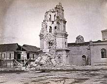
The bell tower of the Manila Cathedral after the series of destructive earthquakes of July 1880.
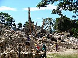
The ruins of a church after the 2013 earthquake.
The table below is a tally of the ten most deadly recorded earthquakes in the Philippines since the 1600s with having the most number of casualties:
18th century
- An intensity VII struck Lake Bombon (now known as Taal Lake) on September 24, 1716. It was connected with the eruption of Taal volcano; the constant volcanic activity in the area of Taal caused seismic movements.
- An intensity IX struck Tayabas (now known as Quezon) in 1730. It had ruined the churches and convent in Mauban and several other churches in the province of Tayabas and Laguna.
19th century
- An earthquake on June 3, 1863, destroyed the Manila Cathedral, the Ayuntamiento (City Hall), the Governor's Palace (all three located at the time on Plaza Mayor, now Plaza de Roma) and much of the city. The residence of the Governor-General was moved to Malacañang Palace located about 3 km (1.9 miles) up the Pasig River, while the other two buildings were rebuilt in place.
- An intensity X struck Luzon on July 14–24, 1880.[13] The quake caused severe damage to these major cities in Luzon, most significantly in Manila where a lot of buildings collapsed. Number of casualties are unknown.[14]
- A quake struck Lucban, Quezon on October 26, 1884. It destroyed churches in Lucban town in Quezon province and Cavinti town in Laguna province.[14]
| Ten deadliest recorded earthquakes in the Philippines since the 1600s | ||||||||||
|---|---|---|---|---|---|---|---|---|---|---|
| Magnitude | Origin | Location | Date | Mortality | Missing | Injured | Damages | Source | ||
| 1 | 7.9 | Tectonic | Moro Gulf | August 16, 1976 | 4791 | 2288 | 9928 | |||
| 2 | 7.8 | Tectonic | Luzon Island | July 16, 1990 | 1666 | 1000 | More than 3000 | ₱ 10 billion | ||
| 3 | 7.5 | Tectonic | Luzon Island | November 30, 1645 | More than 600 | More than 3000 | Unknown | |||
| 4 | 7.3 | Tectonic | Casiguran, Aurora | August 2, 1968 | 271 | 261 | ||||
| 5 | 7.2 | Tectonic | Bohol & Cebu | October 15, 2013 | 222 | 8 | 796 | ₱ 4 billion (est.) | [15] | |
| 6 | 7.1 | Tectonic | Mindoro | November 15, 1994 | 78 | 430 | ₱ 5.15 million | [16] | ||
| 7 | 6.7 | Tectonic | Negros Oriental | February 6, 2012 | 51 | 62 | 112 | ₱ 383 million | ||
| 8 | 8.3 | Tectonic | Panay (Lady Caycay) | January 25, 1948 | 50 (est) | ₱ 7 million | ||||
| 9 | Unknown | Tectonic | Manila | June 19, 1665 | 19 | Unknown | ||||
| 10 | 6.5 | Tectonic | Laoag | August 17, 1983 | 16 | 47 | ||||
| 11 | 7.5 | Tectonic | Mindanao Island | March 5, 2002 | 15 | 100 | ||||
Typhoon
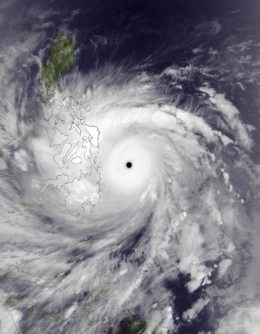
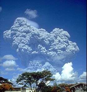
Typhoon Yolanda or Haiyan,strongest typhoon in the Philippines.
Pre-history
- There are no recorded disaster about typhoons in the Philippines Before the History was written, typhoons were never given names.
Cyclones
| Rank | Storm | Dates of impact | Deaths | Ref |
|---|---|---|---|---|
| 1 | 1881 Haiphong typhoon | 1881, September 27–October 6 | 20,000 | [17] |
| 2 | Haiyan/Yolanda 2013 | 2013, November 7–8 | 6,241 | [18] |
| 3 | Thelma (Uring), 1991 | 1991, November 2–7 | 5,956 | [19][20][21] |
| 4 | Bopha/Pablo 2012 | 2012, December 2–9 | 1,901 | |
| 5 | Angela Typhoon, 1867 | 1867, September 20–26 | 1,800 | [17][22][23] |
| 6 | Winnie 2004 | 2004, November 27–30 | 1,593 | |
| 7 | Fengshen/Frank 2008 | 2008, June 18–23 | 1,501 | [20] |
| 8 | Unidentified typhoon | 1897, October 7–16 | 1,500 | [17][22][23] |
| 9 | Ike (Nitang), 1984 | 1984, August 31–September 4 | 1,492 | [19] |
| 10 | Durian/Reming 2006 | 2006, November 29–December 1 | 1,399 | |
| Costliest Philippine typhoons | |||||
|---|---|---|---|---|---|
| Rank | Names | Dates of impact | PHP | USD | Ref |
| 1 | Bopha, (Pablo) | November 25 – December 9, 2012 | 42.2 billion | 1.04 billion | [24] |
| 2 | Haiyan, (Yolanda) | November 3 – 11, 2013 | 35.5 billion | 809 million | [25] |
| 3 | Parma, (Pepeng) | October 2 – 10, 2009 | 27.3 billion | 608 million | [26] |
| 4 | Nesat, (Pedring) | September 26 – 28, 2011 | 15 billion | 333 million | [27] |
| 5 | Fengshen, (Frank) | June 20 – 23, 2008 | 13.5 billion | 301 million | [28] |
| 6 | Ketsana, (Ondoy) | September 25 – 27, 2009 | 11 billion | 244 million | [26] |
| 7 | Mike, (Ruping) | November 10 – 14, 1990 | 10.8 billion | 241 million | [29] |
| 8 | Angela, (Rosing) | October 30 – November 4, 1995 | 10.8 billion | 241 million | [29] |
| 9 | Flo, (Kadiang) | October 2 – 6, 1993 | 8.75 billion | 195 million | [29] |
| 10 | Megi (Juan) | October 18 – 21, 2010 | 8.32 billion | 193 million | [30] |
Extinctions
- Extinctions might be caused by natural calamities, like climate changes, astronomical events, volcanic eruptions, earthquakes, wild fires, floods, and human hunting activities.
.jpg)
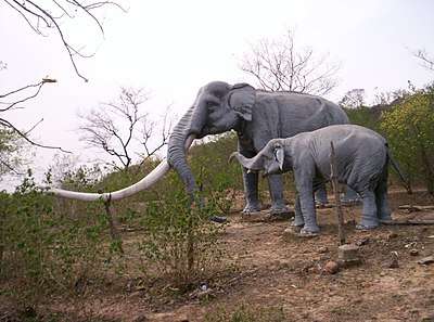
Diprotodon became extinct around 50,000 years ago, Due to Climate change.
| Period | Start Date | Extinction | Date | Cause |
|---|---|---|---|---|
| Mid-Holocene | Extinction of Large Mammals | 2050 BC | Volcanic Eruption. and Climate change | |
| Holocene | 500,000 years ago | Extinction of Large Animals | Volcanic Eruptions.A volcanic eruption occurred In the present location of Taal lake, during Mid-Holocene, causes the Species of Proboscideans like Stegodon to become exitinct. | |
| Pleistocene | 2 million -13,000 yrs ago | Quaternary extinction event | 640,000, 74,000, and 13,000 years ago | Clovis comet? (13,000 years ago) Eruption of Super Volcano? (640,000 years ago)[1] Hunting by humans? Climate change? |
| Pliocene | Pliocene–Pleistocene boundary marine extinction | 2 Ma | ||
See also
References
- 1 2 https://www.academia.edu/925184/Extinction_in_the_Late_Quaternary_Period
- 1 2 Benitez, Narciso; Maíz-Apellániz, Jesús; Canelles, Matilde (2002). "Evidence for Nearby Supernova Explosions". Phys. Rev. Lett. 88 (8): 081101. arXiv:astro-ph/0201018. Bibcode:2002PhRvL..88h1101B. doi:10.1103/PhysRevLett.88.081101. PMID 11863949.
- ↑ http://lunarmeteoritehunters.blogspot.com/2011/03/tablas-island-philippines-fiery-and.html
- 1 2 3 Smithsonian Institution's Global Volcanism Program, Panay page
- ↑ "Malinao » Summary". Global Volcanism Program. Smithsonian Institution. Retrieved 11 January 2013.
- ↑ "Eruptive History of Mariveles". Global Volcanism Program. Retrieved on 2011-07-28.
- ↑ Hargrove, Thomas (1991). "The Mysteries of Taal, a Philippine volcano and lake, her sea life and lost towns". Bookmark, Manila. ISBN 971-569-046-7.
- ↑ "Leonard Range Eruption History". Global Volcanism Program. Retrieved on 2011-08-18.
- ↑ "San Pablo Volcanic Field Eruption History". Global Volcanism Program. Retrieved on 2011-08-18.
- ↑ USGS. "Earthquake Information for 1990". Archived from the original on 2009-12-06. Retrieved 2010-03-06.
- ↑ Becker, George F. (1901). "Report on the Geology of the Philippine Islands", p.42-43. Washington Government Printing Office, 1901.
- ↑ http://www.taalvolcano.org/information.htm
- ↑ Maso, Saderra (1902). Seismic and Volcanic Centers of the Philippine Archipelago. Manila: Bureau of Printing. p. 16.
- 1 2 Bautista, Maria Leonila P. & Bautista, Bartolome C. "Philippine Historical Earthquakes and Lessons Learned" (PDF). EqTAP Project.
- ↑ "Massive extremely dangerous earthquake in Bohol, Philippines – At least 222 people killed, 8 missing, over 790 injured, around 4 billion PHP damage, 7 billion PHP reconstruction costs". Earthquake-Report.com. October 31, 2013. Retrieved October 2013. Check date values in:
|accessdate=(help) - ↑ "1994 Mindoro Tsunami". Philippine Institute of Volcanology and Seismology. Retrieved February 7, 2012.
- 1 2 3 "Tropical Cyclone Disasters in the Philippines: A Listing of Major Typhoons by Month Through 1979" Retrieved 03-27-2018.
- ↑ "TyphoonHaiyan - RW Updates". United Nations Office for the Coordination of Humanitarian Affairs. December 28, 2013. Philippines: Hundreds of corpses unburied after Philippine typhoon. Retrieved December 30, 2013.
- 1 2 "Typhoon2000.com:THE 10 WORST TYPHOONS OF THE PHILIPPINES (A SUMMARY)". www.Typhoon2000.ph. 2004. Archived from the original on 2008-05-22. Retrieved 2018-03-27.
- 1 2 "Typhoon2000.com:THE 12 WORST TYPHOONS OF THE PHILIPPINES (A SUMMARY)". www.typhoon2000.ph. 2010-07-29. Retrieved 2018-03-27.
- ↑ "Top 25 Natural Disasters in Philippines (1901-2000)" Retrieved 03-26-2018.
- 1 2 Pedro Ribera, Ricardo Garcia-Herrera & Luis Gimeno (July 2008). "Historical deadly typhoons in the Philippines". Weather. Royal Meteorological Society. 63 (7): 196. Bibcode:2008Wthr...63..194R. doi:10.1002/wea.275.
- 1 2 "Historical deadly typhoons in the Philippines" Retrieved 03-27-2018.
- ↑ "Archived copy" (PDF). Archived from the original (PDF) on 2013-11-10. Retrieved 2014-06-02.
- ↑ Typhoon Haiyan death toll rises over 5,000 (Report). BBC. November 22, 2013. Retrieved November 22, 2013.
- 1 2 "Situation report no.50 on Typhoon Ondoy (Ketsana) and Typhoon Pepeng (Parma)" (PDF). Philippine National Disaster Coordinating Council. 2009-11-17. Retrieved 2010-05-14.
- ↑ As Typhoon Nesat departs, Philippines tallies the damage | MNN - Mother Nature Network Archived 2014-07-03 at the Wayback Machine.
- ↑ "Archived copy" (PDF). Archived from the original (PDF) on 2008-09-09. Retrieved 2014-06-02.
- 1 2 3 "Destructive typhoons 1970-2003". National Disaster Coordinating Council. 2009-05-01. Archived from the original on 2004-10-28. Retrieved 2010-05-13.
- ↑ "Typhoon Juan Update" (PDF). NDRRMC (formerly NDCC). 2010-10-23. Archived from the original (PDF) on 2011-08-23. Retrieved 2010-10-23.
External links
- Official Website of the National Museum of Natural History
- http://www.preventionweb.net/english/countries/statistics/?cid=135
- http://www.gmanetwork.com/news/story/341514/scitech/science/the-7-worst-natural-calamities-to-hit-phl-in-2013
- http://www.philstar.com/headlines/2013/12/26/1272092/yearender-2013-year-major-natural-disasters
- http://www.mapreport.com/subtopics/d/countries/philippines.html
This article is issued from
Wikipedia.
The text is licensed under Creative Commons - Attribution - Sharealike.
Additional terms may apply for the media files.