List of bridges in Seattle
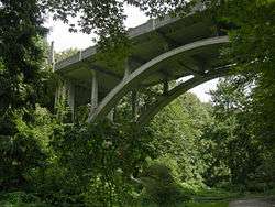
The city of Seattle has multiple bridges that are significant due to their function, historical status, or engineering. Bridges are needed to cross the city's waterways and hilly topography.[1] Twelve bridges have been granted historical status by the city, federal government, or both. Seattle also has some of the only permanent floating pontoon bridges in the world.[2]
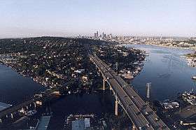
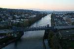
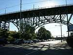
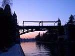
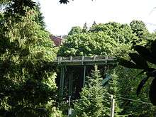
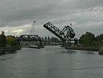
Lake Washington and Puget Sound are to the east and west of the city, respectively. They connect via a series of canals and Lake Union that are collectively known as the Lake Washington Ship Canal.[3] The four double-leaf bascule bridges crossing the Ship Canal are the oldest in the city, having opened between 1917 and 1930. The easternmost—the Montlake and University bridges—connect neighborhoods south of the canal to the University District. The Fremont Bridge crosses the center of the canal and is one of the most often raised drawbridges in the world due to its clearance over the water of only 30 feet (9.1 m).[4] The westernmost crossing of the ship canal is the Ballard Bridge.[5]
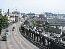
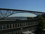
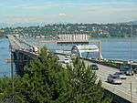
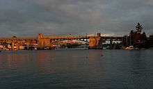
The floating bridges carry Interstate 90 and State Route 520 across Lake Washington to the Eastside suburbs.[6] The SR 520 Albert D. Rosellini Evergreen Point Floating Bridge, which opened in 2016 as the replacement for another floating bridge at the same site,[7][8] is the longest floating bridge in the world.[9][10] The Lacey V. Murrow Memorial Bridge had previously been replaced after the original span sunk in 1990 when water filled an open maintenance hatch during refurbishing. Age and the 2001 Nisqually earthquake have damaged several other spans. The risk of future earthquakes has increased the need to replace already deteriorated bridges in the city, such as the Alaskan Way Viaduct and the Magnolia Bridge.[11][12]
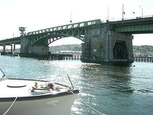
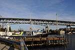
The neighborhoods that make up West Seattle are on a peninsula separated from downtown by the Duwamish River. The West Seattle Bridge is the primary roadway crossing the river.[13] The neighborhood's Spokane Street Bridge is the world's first and only hydraulically operated concrete double-leaf swing bridge.[14]
List of bridges
| Key: Year opened |
|---|
| *: Listed in the National Register of Historic Places[15] |
| †: Listed as a city landmark[16] |

.jpg)
_from_east_end_after_opening%2C_April_2016.jpg)
See also

| Wikimedia Commons has media related to Bridges in Seattle. |
- List of bridges on the National Register of Historic Places in Washington (state)
- List of Seattle landmarks
- South Park Bridge, just outside the city limits
- East Channel Bridge, connects the Interstate 90 bridges with the Eastside suburbs via Mercer Island
Notes
- ↑ A parallel span was built in 1996; the approaches to the original span were partially demolished and the structure was retrofitted between 1996 and 1998.[22]
- ↑ The city rebuilt the approaches at each end of the bridge between 2006 and 2007.[24]
- ↑ Commonly known as the "Aurora Bridge" but the structure was named after George Washington.[26]
- ↑ Known as the "West Seattle Bridge" but the span was renamed for a city council member in 2009.[27]
- ↑ Known as the "12th Avenue South Bridge" but named in honor of José Rizal.[29]
- ↑ All but the approaches replace the original bridge, which opened in 1940 and sank in 1990.[23]
- ↑ Replaced a 1963 bridge at the same site. The original bridge was initially called the "Evergreen Point Floating Bridge" but renamed in honor of Albert Rosellini.[39]
- ↑ Remodeled and dedicated in 1933.[20]
References
- ↑ Petroski, Henry (2003). "Floating Bridges" (PDF). American Scientific. 91: 302–306.
- ↑ Gutierres, Scott (February 29, 2012). "Washington: Floating Bridge Capitol of the World". Seattle Post Intelligencer. Retrieved January 4, 2015.
- ↑ Insiders' Guide to Seattle. Insiders Guides. 2010. p. 17. ISBN 978-0-7627-5544-8.
- ↑ Posada, Janice (August 21, 1995). "The People Who Operate Seattle's Movable Bridges Can Attest to the Ups and Downs of Solitary Work Tender Times". Seattle Post-Intelligencer.
- ↑ Ohlsen, Becky (2008). Seattle. Lonely Planet. p. 44. ISBN 978-1-74059-834-7.
- ↑ Petroski, Henry (2005). Pushing the Limits: New Adventures in Engineering. Knopf. p. 40. ISBN 978-1-4000-4051-3.
- 1 2 Lindblom, Mike (January 12, 2016). "New 520 bridge to open in April; walkers, bicyclists get to try it first". The Seattle Times. Retrieved April 17, 2016.
- ↑ "Traffic switch from old SR 520 floating bridge to new bridge" (PDF). Washington State Department of Transportation. January 2016. Archived from the original (PDF) on April 17, 2016. Retrieved April 20, 2016.
- ↑ Gaudette, Karen (April 26, 2005). "DOT on 520 project: "The Sooner the Better"". The Seattle Times. Retrieved February 22, 2011.
- 1 2 "Longest bridge, floating bridge". Guinness World Records. Retrieved April 17, 2016.
- ↑ "Demolition of the Alaskan Way Viaduct begins". Seattle Post-Intelligencer. February 18, 2011. Retrieved February 27, 2011.
- 1 2 Cunningham, Jeffrey (November 25, 2014). "Magnolia's Bridges". Queen Anne & Magnolia News. Retrieved December 19, 2014.
- ↑ Southwest Seattle Historical Society, Log House Museum (2010). Images of America West Seattle. Arcadia Publishing. p. 20. ISBN 978-0-7385-8133-0.
- 1 2 3 Holstine, Craig; Hobbs, Richard (2005). Spanning Washington: Historic Highway Bridges of the Evergreen State. Washington State University Press. ISBN 978-0-87422-281-4.
- ↑ National Register of Historic Places; Annual Listing of Historic Properties (Part II) (PDF). National Park Service. March 1, 1983. p. 8669.
- ↑ "Landmarks and Designation". City of Seattle Department of Neighborhoods. Retrieved February 28, 2011.
- ↑ WSDOT Projects: Alaskan Way Viaduct and Seawall Replacement
- 1 2 3 Landmark Preservation Board (April 1, 1975). "Seattle Historic Building Data Sheet" (PDF). City of Seattle. Archived from the original (PDF) on December 20, 2013. Retrieved December 19, 2014.
- ↑ Dorpat, Paul (August 12, 2001). "A Bridge Loses Track". The Seattle Times. Archived from the original on February 17, 2009. Retrieved February 3, 2011.
- 1 2 3 4 "Bridges and Roadway Structures". City of Seattle Department of Transportation. Retrieved February 3, 2011.
- 1 2 Blecha, Peter (January 23, 2011). "Ravenna Park (Seattle)". HistoryLink.org Online Encyclopedia of Washington State History. Retrieved November 28, 2011.
- ↑ "1st Avenue S. Bridge". Washington State Department of Transportation. Retrieved February 3, 2011.
- 1 2 3 4 5 6 The World Almanac and Book of Facts 2008. World Almanac Books. 2008. pp. 737–739. ISBN 978-1-60057-072-8.
- ↑ Gilore, Susan (May 22, 2006). "Project Will Keep Bus Traffic off Bridge in Fremont". The Seattle Times. Retrieved February 22, 2011.
- 1 2 Shellin Atly, Elizabeth (January 2, 1980). "Nomination Form" (PDF). City of Seattle; Department of Community Development/Office of Urban Conservation. Archived from the original (PDF) on March 24, 2014. Retrieved December 19, 2014.
- 1 2 Gilore, Susan (July 15, 2008). "3 Designs Released for Fence on Aurora Bridge". The Seattle Times. Retrieved February 22, 2010.
- 1 2 "West Seattle Bridge Honors Jeanette Williams". West Seattle Herald. October 30, 2009.
- ↑ "The Northwest Today". The Register-Guard. July 8, 1984. p. 5A.
- ↑ Long, Priscilla (December 23, 2007). "Seattle's 12th Avenue South (Dearborn Street) Bridge Is Built in 1911". HistoryLink.org Online Encyclopedia of Washington State History.
- 1 2 "View From on High". City of Seattle Department of Transportation. August 24, 2010. Retrieved February 27, 2011.
- ↑ "Magnolia Bridge Site Recommended". The Daily Journal of Commerce. February 9, 2006. Archived from the original on March 30, 2006. Retrieved December 19, 2014.
- 1 2 Gelula, Melisse (2002). Fodor's Cityguide Seattle. Fodor's Travel Publications. p. 171. ISBN 978-0-676-90194-8.
- 1 2 Wilma, David (April 17, 2001). "Seattle Landmarks: Queen Anne Drive Bridge (1936)". HistoryLink.org Online Encyclopedia of Washington State History. Retrieved December 19, 2014.
- ↑ Shellin Atly, Elizabeth (January 2, 1980). "Nomination Form" (PDF). City of Seattle; Department if Community Development/Office of Urban Conservation. Archived from the original (PDF) on March 24, 2014. Retrieved December 19, 2014.
- ↑ The Encyclopedia Americana: A Library of Universal Knowledge, Volume 4. Encyclopedia Americana Corporation. 1918. p. 504. ISBN 978-1-2763-9784-1.
- ↑ "Final List of Nationally and Exceptionally Significant Features of the Federal Interstate Highway System". Federal Highway Administration, USDOT. Retrieved December 19, 2014.
- ↑ Dorpat, Paul; McCoy, Genevieve (1998). Building Washington: A History of Washington State Public Works. Tartu Publications. p. 131. ISBN 978-0-9614357-9-0.
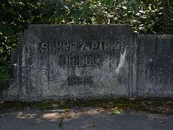
- ↑ Long, Priscilla (December 23, 2007). "Schmitz Park Bridge in West Seattle Is Completed in December 1936". HistoryLink.org Online Encyclopedia of Washington State History. Retrieved December 19, 2014.
- ↑ "Weekly Roundup of Facts, Figures and Forecasts". The Seattle Times. August 25, 2004. Retrieved July 11, 2011.
- ↑ Long, Priscilla (January 23, 2008). "Seattle's Ravenna Park Bridge Is Constructed in 1913". HistoryLink.org Online Encyclopedia of Washington State History. Retrieved November 28, 2011.