Hinunangan, Southern Leyte
| Hinunangan | ||
|---|---|---|
| Municipality | ||
| Municipality of Hinunangan | ||
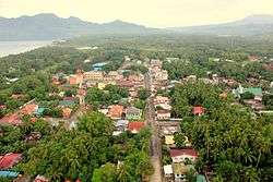 Aerial view of Hinunangan | ||
| ||
| Motto(s): Rice Granary of Southern Leyte | ||
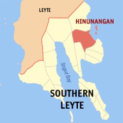 Map of Southern Leyte with Hinunangan highlighted | ||
.svg.png) Hinunangan Location within the Philippines | ||
| Coordinates: 10°24′N 125°12′E / 10.4°N 125.2°ECoordinates: 10°24′N 125°12′E / 10.4°N 125.2°E | ||
| Country |
| |
| Region | Eastern Visayas (Region VIII) | |
| Province | Southern Leyte | |
| District | Lone District | |
| Barangays | 40 (see Barangays) | |
| Government [1] | ||
| • Type | Sangguniang Bayan | |
| • Mayor | Sonny Fernandez | |
| • Vice Mayor | Florentino Fernandez Jr. | |
| • Electorate | 18,535 voters (2016) | |
| Area [2] | ||
| • Total | 170.58 km2 (65.86 sq mi) | |
| Population (2015 census)[3] | ||
| • Total | 29,976 | |
| • Density | 180/km2 (460/sq mi) | |
| Time zone | UTC+8 (PST) | |
| ZIP code | 6608 | |
| PSGC | 086403000 | |
| IDD : area code | +63 (0)53 | |
| Climate type | Tropical rainforest climate | |
| Income class | 3rd municipal income class | |
| Revenue (₱) | 95,473,099.97 (2016) | |
| Native languages |
Boholano dialect Cebuano Tagalog | |

Hinunangan, officially the Municipality of Hinunangan, is a 3rd class municipality in the province of Southern Leyte, Philippines. According to the 2015 census, it has a population of 29,976 people.[3]
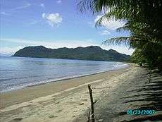
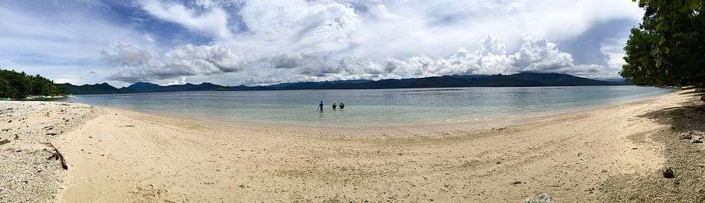
Hinunangan is known as the "Rice Granary of the Province" for its vast plain land that is entirely planted with rice. Hinunangan has great potential for tourism because of its beautiful sand beaches and islands. The town is also a producer of rattan and wood-based furnitures, abaca handicrafts items, pineapple, vegetables, other forest products, and bamboo furnitures. It has a potential for mineral water and root crops processing and copper mining.[4]
Hinunangan is also known as a major gateway in Leyte because of its near proximity to Tacloban City. The opening of Abuyog–Silago Road cuts travel time from Tacloban by half from the previous 6 hours to less than 3 hours. It is also the place in Southern Leyte with the most immigrants from Europe and North America.
It has a lot of touristic places, such as Tahusan, Talisay or the twin islands (known as Cabugan Grande and Cabugan Chico as Pigafetta stated in his account during their travel with Magellan).. There are also hotels, inns, a public market and beach resorts.
Geography
Hinunangan is home to the highest mountain in the province, Mount Nacolod, with an elevation of 948 metres (3,110 ft) above sea level.[5]
Barangays


Hinunangan is politically subdivided into 40 barangays, two of which are island barangays located at the east of the town. The twin islands are accessible by motorized boats through Barangay Canipa-an.
| Barangay | Population (2007) |
Population (2010) |
Population (2015) |
|---|---|---|---|
| Ambacon | |||
| Badiangon | |||
| Bangcas A | |||
| Bangcas B | |||
| Biasong | |||
| Bugho | |||
| Calag-itan | |||
| Calayugan | |||
| Calinao | |||
| Canipaan | |||
| Catublian | |||
| Ilaya | |||
| Ingan | |||
| Labrador | |||
| Libas | |||
| Lumbog | |||
| Manalog | |||
| Manlico | |||
| Matin-ao | |||
| Nava | |||
| Nueva Esperanza | |||
| Otama | |||
| Palongpong | |||
| Panalaron | |||
| Patong | |||
| Poblacion | |||
| Pondol | |||
| Salog | |||
| Salvacion | |||
| San Pablo Island | |||
| San Pedro Island | |||
| Santo Niño I | |||
| Santo Niño II | |||
| Tahusan | |||
| Talisay | |||
| Tawog | |||
| Toptop | |||
| Tuburan | |||
| Union | |||
| Upper Bantawon |
History
In 1521, Magellan recorded sighting Hunonganan (Hinunangan) during the voyage in Leyte Gulf. As far back in 1750, Hinunangan was a mid-way station of Boholanos trading in Eastern Leyte. They rested overnight at the mouth of Das-ay River where they moored their boats. A shelter was built for the crews and tenders known as "hononganan" or stopover. Hence the name. In 1822, a certain Boholano named Palonoy founded Hinunangan.[6] At this time, Silago to the north and Hinundayan and Anahawan to the south were part of Hinunangan.
In 1944, in the greatest naval battle in history the blocking warship of the Liberation waylaid the Japanese Fleet near Hinunangan. Thus, the area in Southern Leyte is the natural frontier of historically significant events in Philippine history.
2007 earthquake
On July 19, 2007, a strong earthquake hit the town with magnitude 6 on Richter scale and damaged some properties. The partial assessment report of Hinunangan dated July 20, a copy of which was obtained by PIA through Gov. Mercado, placed the estimated cost of damage to properties at P1,650,000.00 broken down as P790,000 for government infrastructure and P860,000 from private infrastructure.[7]
Among the public properties destroyed were the water system - P 500,000; Das-ay Bridge railguard - P100,000; East Central School Concrete Fence - P80,000; Otama Elementary School - P50,000; Patong Elementary School - P40,000; and Tahusan Elementary School—P20,000.[7]
The private infrastructure damaged included the Roman Catholic Bell tower - P100,000; Water tank of the Catholic convent - P40,000; Manalog barangay Chapel - P20,000; Sto. Nino barangay Chapel - P10,000; a number of houses - P400,000, and various appliances, P290,000.
Demographics
| Population census of Hinunangan | ||
|---|---|---|
| Year | Pop. | ±% p.a. |
| 1990 | 22,454 | — |
| 1995 | 22,170 | −0.24% |
| 2000 | 25,016 | +2.62% |
| 2007 | 27,712 | +1.42% |
| 2010 | 28,415 | +0.92% |
| 2015 | 29,976 | +1.02% |
| Source: Philippine Statistics Authority [3][8][9][10] | ||
Education
High schools:
- Holy Rosary Academy - a Roman Catholic school
- Hinunangan National High School - formerly Hinunangan Agricultural and Vocational School
- Canipaan National High School
- Nava National High School
Universities:
- Southern Leyte State University (SLSU)- Hinunangan Campus (formerly Southern Leyte Institute of Agriculture and Technology (SLIAT)). Courses Offered:
- BS in Agricultural Entrepreneurship
- BS Education
- Bachelor of Agricultural Technology
- Associate in Agricultural Technology
- Associate in Information Technology
- Bachelor of Science in Information Technology
Other:
- Hinunangan Skills and Technological Center[11] - TESDA accredited vocational school. Courses Offered:
- Commercial Cooking
- Computer Hardware Servicing
- Consumer Electronics Servicing
- Electrical Installation & Maintenance
- Food & Beverage Services
- Shielded Metal Arc Welding
Health Care
- Zenon T. Lagumbay Memorial Hospital
- Hinunangan Community Hospital
Commerce
Banking and Finance
- Philippine National Bank[12]
- Saints Peter & Paul Multi-Purpose Cooperative
Media
- Hinunangnon - crowdsourcing social news network in Hinunangan, founded in 2016 that brings digital news and top stories locally from Hinunangan and its Province or around the world. [13]. [14].
- 92.1 Spin Radio - first FM radion station in Hinunangan and the Pacific Area in Southern Leyte. Broadcast transmission and studio is located in Hinunangan Commercial Complex. [15]
Communication
Mobile:
- Smart Communications (Since 2002)
- Globe Telecom (Since 2004)
- Sun Cellular (Since 2012)
Cable television:
- Fiesta Cable TV
- Direct-To-Home (DTH) satellite TV service providers
Internet:
- Wireless Internet through SMART Network (Smart Bro's 3G/HSPA/HSPA+)
- Wireless Internet through Globe Network (Globe Tattoo)
References
- ↑ "Municipality". Quezon City, Philippines: Department of the Interior and Local Government. Retrieved 31 May 2013.
- ↑ "Province: Southern Leyte". PSGC Interactive. Quezon City, Philippines: Philippine Statistics Authority. Retrieved 12 November 2016.
- 1 2 3 Census of Population (2015). "Region VIII (Eastern Visayas)". Total Population by Province, City, Municipality and Barangay. PSA. Retrieved 20 June 2016.
- ↑ "Archived copy". Archived from the original on 2006-05-21. Retrieved 2008-11-05. , Southern Leyte LGU website
- ↑ Archived 2008-11-18 at the Wayback Machine., NSCB Southern Leyte Profile
- ↑ Hinunangan History, Hinunangan.net
- 1 2 Hinunangan MDCC bares earthquake partial damage assessment report, Philippine Information Agency
- ↑ Census of Population and Housing (2010). "Region VIII (Eastern Visayas)". Total Population by Province, City, Municipality and Barangay. NSO. Retrieved 29 June 2016.
- ↑ Censuses of Population (1903–2007). "Region VIII (Eastern Visayas)". Table 1. Population Enumerated in Various Censuses by Province/Highly Urbanized City: 1903 to 2007. NSO.
- ↑ "Province of Southern Leyte". Municipality Population Data. Local Water Utilities Administration Research Division. Retrieved 17 December 2016.
- ↑ TESDA Hinunangan Skills and Technological Center
- ↑ PNB_Domestic_Branch_Directory
- ↑ | Hinunangnon Facebook Page
- ↑ | Hinunangnon Official Website
- ↑ | 92.1 Spin Radio Facebook page
External links
| Wikimedia Commons has media related to Hinunangan, Southern Leyte. |
- Tourist Office Official Site
- Philippine Standard Geographic Code
- Philippine Census Information
- Local Governance Performance Management System
- Southern Leyte State University - Hinunangan Campus
- Travels through Hinunangan
Places adjacent to Hinunangan, Southern Leyte | ||||||||||
|---|---|---|---|---|---|---|---|---|---|---|
| ||||||||||