Lickingville, Pennsylvania
| Lickingville, Pennsylvania | |
|---|---|
| Unincorporated community | |
 Lickingville | |
| Coordinates: 41°22′40″N 79°22′06″W / 41.37778°N 79.36833°WCoordinates: 41°22′40″N 79°22′06″W / 41.37778°N 79.36833°W | |
| Country | United States |
| State | Pennsylvania |
| County | Clarion |
| Elevation | 1,588 ft (484 m) |
| Time zone | UTC-5 (Eastern (EST)) |
| • Summer (DST) | UTC-4 (EDT) |
| ZIP code | 16332 |
| Area code(s) | 814 |
| GNIS feature ID | 1209757[1] |
Lickingville is an unincorporated community in Clarion County, Pennsylvania, United States.[1] The community is located along Pennsylvania Route 208 9.3 miles (15.0 km) south-southeast of Tionesta. Lickingville had a post office until June 4, 2011; it still has its own ZIP code, 16332.[2][3]
References
- 1 2 "Lickingville". Geographic Names Information System. United States Geological Survey.
- ↑ United States Postal Service. "USPS - Look Up a ZIP Code". Retrieved July 16, 2017.
- ↑ "Postmaster Finder - Post Offices by ZIP Code". United States Postal Service. Retrieved July 16, 2017.
Municipalities and communities of Clarion County, Pennsylvania, United States | ||
|---|---|---|
| Boroughs | 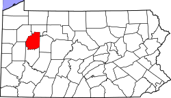 | |
| Townships | ||
| CDPs | ||
| Unincorporated communities | ||
| Footnotes | ‡This populated place also has portions in an adjacent county or counties | |
This article is issued from
Wikipedia.
The text is licensed under Creative Commons - Attribution - Sharealike.
Additional terms may apply for the media files.