Aguascalientes International Airport
| Jesús Terán Peredo International Airport | |||||||||||||||
|---|---|---|---|---|---|---|---|---|---|---|---|---|---|---|---|
 | |||||||||||||||
| Summary | |||||||||||||||
| Airport type | Public | ||||||||||||||
| Operator | Grupo Aeroportuario del Pacífico | ||||||||||||||
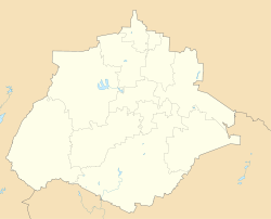
| Serves | Aguascalientes, Aguascalientes, Mexico | ||||||||||||||
| Elevation AMSL | 6,112 ft / 1,863 m | ||||||||||||||
| Coordinates | 21°42′20″N 102°19′04″W / 21.70556°N 102.31778°WCoordinates: 21°42′20″N 102°19′04″W / 21.70556°N 102.31778°W | ||||||||||||||
| Map | |||||||||||||||
 AGU AGU | |||||||||||||||
| Runways | |||||||||||||||
| |||||||||||||||
| Statistics (2017) | |||||||||||||||
| |||||||||||||||
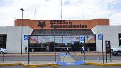
Lic. Jesús Terán Peredo International Airport (Spanish: Aeropuerto Internacional Lic. Jesús Terán Peredo, IATA: AGU, ICAO: MMAS), also known as Aguascalientes International Airport, serves Aguascalientes, the capital city of the state of Aguascalientes in Mexico. It handles national and international air traffic for the city of Aguascalientes. The airport was named after Jesús Terán Peredo, an Aguascalientes governor from 1855 to 1857, and one of the first persons to recognize Benito Juárez as Mexico's president.
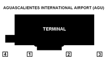
Its commercial facilities consist of a sole terminal, with four contact positions plus three remotes used by non-mainline carriers. The terminal has been recently remodeled and expanded to meet the growing demand. The airport is now able to handle 1.5 million passengers, although it only handled 0.4 million during 2012. Several amenities have been recently opened, such as the introduction of a new restaurant on the upper level of the airport, new check-in counters, among many others. The airport has become one of the most important terminals in the Central-West region of Mexico.
Facilities
The airport is at an elevation of 6,112 feet (1,863 m) above mean sea level. It has one active runway designated 17/35 with an asphalt surface measuring 3,000 by 45 metres (9,843 ft × 148 ft). A former runway designated 04/22 is now closed; it had an asphalt surface measuring 1,060 by 30 metres (3,478 ft × 98 ft).[1]
It handled 693,700 passengers in 2016, and 754,100 passengers in 2017.
Airlines and destinations
| Airlines | Destinations |
|---|---|
| Aeroméxico Connect | Mexico City |
| American Eagle | Dallas/Fort Worth |
| Interjet | Cancún, Mexico City, Monterrey, Puerto Vallarta |
| Magni | Seasonal: Cancún |
| TAR Aerolineas | Puerto Vallarta Seasonal:[2] Guadalajara, Monterrey, Querétaro |
| United Express | Houston–Intercontinental |
| Volaris | Cancún, Los Angeles, Mexico City (begins November 1, 2018),[3] Tijuana |
Busiest routes
| Rank | City | Passengers | Ranking | Airline |
|---|---|---|---|---|
| 1 | 168,219 | Aeroméxico, Aeroméxico Connect, Interjet | ||
| 2 | 84,532 | Volaris | ||
| 3 | 31,308 | Interjet, Magni, Volaris | ||
| 4 | 6,658 | Interjet, TAR | ||
| 5 | 6,239 | Interjet | ||
| 6 | 138 | |||
| 7 | 97 | |||
| 8 | 92 | |||
| 9 | 80 | |||
| 10 | 68 |
References
- 1 2 Airport information for MMAS from DAFIF (effective October 2006)
- ↑ "More options to travel to Aguascalientes". Transportes Aéreos Regionales. Retrieved March 24, 2018.
- ↑ "Volaris announces new routes from Mexico City" (in Spanish). EnElAire. August 2018. Retrieved August 7, 2018.
- ↑ "Operational Statistics of Airports in the ASA Network" (in Spanish). Aeropuertos y Servicios Auxiliares. January 2018. Retrieved March 6, 2018.