Le Mars, Iowa
| Le Mars, Iowa | |
|---|---|
| City | |
 | |
| Nickname(s): "Ice Cream Capital Of The World" | |
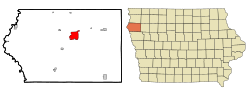 Location of Le Mars within County and State | |
 U.S. Census Map | |
| Coordinates: 42°47′20″N 96°9′57″W / 42.78889°N 96.16583°WCoordinates: 42°47′20″N 96°9′57″W / 42.78889°N 96.16583°W | |
| Country |
|
| State |
|
| County | Plymouth |
| Government | |
| • Type | Mayor-council |
| • Mayor | Dick Kirchoff |
| Area[1] | |
| • Total | 8.97 sq mi (23.23 km2) |
| • Land | 8.96 sq mi (23.21 km2) |
| • Water | 0.01 sq mi (0.03 km2) |
| Elevation | 1,234 ft (376 m) |
| Population (2010)[2] | |
| • Total | 9,826 |
| • Estimate (2016)[3] | 9,935 |
| • Density | 1,097/sq mi (423.4/km2) |
| Time zone | UTC-6 (Central (CST)) |
| • Summer (DST) | UTC-5 (CDT) |
| ZIP code | 51031 |
| Area code(s) | 712 |
| FIPS code | 19-44400 |
| GNIS feature ID | 0458255 |
| Website | lemarsiowa.com |
Le Mars is a city in and the county seat of Plymouth County, Iowa, United States.[4] It is located on the Floyd River and is northeast of Sioux City. The population was 9,826 at the 2010 census.
Le Mars is the home of Wells Enterprises, Inc.,self proclaimed world's largest producer of ice cream novelties in one location and is the "Ice Cream Capital of the World". Wells is best known for its Blue Bunny products.
History
Le Mars was platted in 1869, but no lots were sold until the Chicago and North Western Transportation Company arrived in 1879. According to town legend, CNW investor John I. Blair and a group of women arrived at the town, which was then called St. Paul Junction. Blair asked the women to name the town, and they submitted an acronym based upon their first names' initials: Lucy Underhill, Elizabeth Parson, Mary Weare, Anna Blair, Rebecca Smith and Sarah Reynolds.[5]
In 1885, Frederick Brooke Close, a young Englishman who had passed up attending Cambridge University to live in Iowa, founded the Northwestern Polo League in Le Mars.[6][7]
During the Great Depression in 1933, at a time when banks were foreclosing on many farmers, Le Mars caught the attention of the nation when "over five hundred farmers crowded the court room in Le Mars", according to an account by historian Arthur Schlesinger, Jr.. The farmers were there to demand that Judge Charles C. Bradley suspend foreclosure proceedings until recently passed laws could be considered. Judge Bradley refused. One farmer remarked that the court room wasn't his alone, that farmers had paid for it with their taxes. The crowd rushed the judge, slapped him, and placed a rope around his neck and a hub cap on his head. They did not, however lynch him.[8]
Fred H. Wells opened a milk route in Le Mars in 1913. By 1925, Wells and his sons had opened an ice cream manufacturing plant there. However, the plant (and the Wells name) was purchased by Fairmount Ice Cream in 1928. In 1935, Fred and his sons sought to begin selling ice cream again, but could no longer use their name. They therefore sponsored a “Name That Ice Cream” contest in the Sioux City Journal. The winner of the $25 prize suggested "Blue Bunny" because his son had enjoyed seeing blue bunnies in department store windows at Easter.
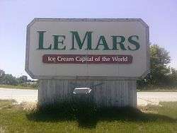
"Ice Cream Capital of the World"
Dominating the skyline of present-day Le Mars is Wells' Blue Bunny Dairy's 900,000-square-foot (84,000 m2) plant with a 12-story tall refrigeration tower called the "South Ice Cream Plant" - so-named because it is on the south side of town. As of 2005, the plant employed 1,000 and produces 75 million gallons of frozen treats, the milk coming mainly coming from three large Iowa dairy farms.[9] The size of this plant has led to speculation that the company is the world's largest family-owned and managed dairy processor and the world's largest manufacturer of ice cream in one location, with Le Mars claiming to be the "Ice Cream Capital of the World".
President George W. Bush came to Le Mars on November 3, 2006, to campaign for Jim Nussle, then candidate for Iowa governor.[10] He spoke at Le Mars Community High School to a crowd of a couple thousand.
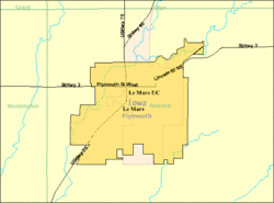
Geography
Le Mars is located at 42°47′20″N 96°9′57″W / 42.78889°N 96.16583°W (42.788799, -96.165944).[11] According to the United States Census Bureau, the city has a total area of 8.97 square miles (23.23 km2), of which 8.96 square miles (23.21 km2) is land and 0.01 square miles (0.03 km2) is water.[1]
Demographics
| Historical population | |||
|---|---|---|---|
| Census | Pop. | %± | |
| 1890 | 4,036 | — | |
| 1900 | 4,146 | 2.7% | |
| 1910 | 4,157 | 0.3% | |
| 1920 | 4,683 | 12.7% | |
| 1930 | 4,788 | 2.2% | |
| 1940 | 5,353 | 11.8% | |
| 1950 | 5,844 | 9.2% | |
| 1960 | 6,767 | 15.8% | |
| 1970 | 8,159 | 20.6% | |
| 1980 | 8,276 | 1.4% | |
| 1990 | 8,454 | 2.2% | |
| 2000 | 9,237 | 9.3% | |
| 2010 | 9,826 | 6.4% | |
| Est. 2016 | 9,935 | [3] | 1.1% |
| U.S. Decennial Census[12] | |||
Le Mars is a part of the Sioux City metropolitan area.
2010 census
As of the census[2] of 2015, there were 9,436 people, 4,013 households, and 2,593 families residing in the city. The population density was 1,096.7 inhabitants per square mile (423.4/km2). There were 4,220 housing units at an average density of 471.0 per square mile (181.9/km2). The racial makeup of the city was 92.5% White, 0.5% African American, 0.3% Native American, 0.7% Asian, 2.9% from other races, and 1.3% from two or more races. Hispanic or Latino of any race were 5.4% of the population.
There were 4,013 households of which 31.8% had children under the age of 18 living with them, 52.3% were married couples living together, 8.5% had a female householder with no husband present, 3.9% had a male householder with no wife present, and 35.4% were non-families. 30.6% of all households were made up of individuals and 13.7% had someone living alone who was 65 years of age or older. The average household size was 2.39 and the average family size was 3.00.
The median age in the city was 39.2 years. 25.9% of residents were under the age of 18; 7.3% were between the ages of 18 and 24; 23.5% were from 25 to 44; 26.3% were from 45 to 64; and 16.8% were 65 years of age or older. The gender makeup of the city was 48.4% male and 51.6% female.
2000 census
As of the census[13] of 2000, there were 9,237 people, 3,640 households, and 2,453 families residing in the city. The population density was 1,356.9 people per square mile (523.7/km²). There were 3,818 housing units at an average density of 560.9 per square mile (216.5/km²). The racial makeup of the city was 97.24% White, 0.45% African American, 0.16% Native American, 0.30% Asian, 0.09% Pacific Islander, 0.94% from other races, and 0.81% from two or more races. Hispanic or Latino of any race were 2.44% of the population.
There were 3,640 households out of which 34.2% had children under the age of 18 living with them, 56.0% were married couples living together, 8.4% had a female householder with no husband present, and 32.6% were non-families. 28.7% of all households were made up of individuals and 13.7% had someone living alone who was 65 years of age or older. The average household size was 2.46 and the average family size was 3.05.
Age spread: 27.2% under the age of 18, 8.3% from 18 to 24, 27.6% from 25 to 44, 20.3% from 45 to 64, and 16.6% who were 65 years of age or older. The median age was 37 years. For every 100 females, there were 92.3 males. For every 100 females age 18 and over, there were 87.8 males.
The median income for a household in the city was $38,892, and the median income for a family was $47,409. Males had a median income of $35,936 versus $21,757 for females. The per capita income for the city was $19,598. About 4.5% of families and 6.2% of the population were below the poverty line, including 7.0% of those under age 18 and 6.7% of those age 65 or over.
Transportation
Le Mars Municipal Airport is owned by the city of Le Mars and located two nautical miles (3.7 km) southwest of its central business district.
Notable people
- Clarence E. Coe, pioneer of Palms, California and member of the Los Angeles, California, City Council, born in Le Mars
- Bruce Dreckman, umpire in Major League Baseball
- Albert W. Durley, Wisconsin State Assemblyman and lawyer
- John Gregory Kelly, Roman Catholic bishop
- Keith Knudsen, drummer for the Doobie Brothers
- Donald Paulin, Iowa state legislator, mayor of Le Mars, and businessman
- Paul Rust, star of I Love You, Beth Cooper and Love (TV series)
- Roger C. Schultz, United States Army Lieutenant General and Director of the Army National Guard
- John Spenkelink, first person involuntarily executed in the United States after the re-introduction of the death penalty
- Charles A. Spring, influential Presbyterian, son of Revolutionary War chaplain Samuel Spring
- Thomas Starzl, innovator in organ transplant surgery
- Isaac S. Struble, congressman and namesake of Struble, Iowa
See also
- Plymouth County Courthouse
- St. George's Episcopal Church
- Tonsfeldt Round Barn, listed on the National Register of Historic Places
- Westmar University A private four-year liberal arts college that permanently closed on November 21, 1997.
- Wells Enterprises Wells Dairy
- Le Mars Public Library
References
- 1 2 "US Gazetteer files 2010". United States Census Bureau. Archived from the original on January 24, 2012. Retrieved May 11, 2012.
- 1 2 "American FactFinder". United States Census Bureau. Retrieved May 11, 2012.
- 1 2 "Population and Housing Unit Estimates". Retrieved June 9, 2017.
- ↑ "Find a County". National Association of Counties. Retrieved June 7, 2011.
- ↑ http://www.msnbc.msn.com/id/21134540/vp/45829898#45829898
- ↑ Horace A. Laffaye, Polo in Britain: A History, Jefferson, North Carolina: McFarland & Company, 2012, p. 70
- ↑ Curtis Harnack, Gentlemen on the Prairie: Victorians in Pioneer Iowa, Iowa City, Iowa: University of Iowa Press, 2011 p. 138
- ↑ Arthur Schlesinger, Jr., The Coming of the New Deal, Houghton Mifflin, 5th printing, 1958, pages 42-43.
- ↑ The big chill: Wells' Dairy's South Ice Cream Plant dominates the world of frozen dessert production - Allbusiness.com - January 1, 2005
- ↑ "Le Mars Daily Sentinel". printed October 30, 2006. Retrieved November 20, 2010.
- ↑ "US Gazetteer files: 2010, 2000, and 1990". United States Census Bureau. February 12, 2011. Retrieved April 23, 2011.
- ↑ "Census of Population and Housing". Census.gov. Retrieved June 4, 2015.
- ↑ "American FactFinder". United States Census Bureau. Retrieved January 31, 2008.
External links
| Wikimedia Commons has media related to Le Mars, Iowa. |
- City of Le Mars
- Blue Bunny Official Site
- Westmar College Unofficial Site
- City Data Comprehensive Statistical Data and more about Le Mars
Municipalities and communities of Plymouth County, Iowa, United States | ||
|---|---|---|
| Cities | ||
| Unincorporated communities | ||
| Footnotes | ‡This populated place also has portions in an adjacent county or counties | |