Lawnton, Queensland
| Lawnton Moreton Bay Region, Queensland | |||||||||||||||
|---|---|---|---|---|---|---|---|---|---|---|---|---|---|---|---|
 Newer shops in Lawnton | |||||||||||||||
| Population | 5,658 (2016 census)[1] | ||||||||||||||
| • Density | 608.4/km2 (1,575.7/sq mi) | ||||||||||||||
| Postcode(s) | 4501 | ||||||||||||||
| Area | 9.30 km2 (3.6 sq mi) | ||||||||||||||
| Location | 23 km (14 mi) from Brisbane GPO | ||||||||||||||
| LGA(s) | Moreton Bay Region | ||||||||||||||
| State electorate(s) | |||||||||||||||
| Federal Division(s) | Dickson | ||||||||||||||
| |||||||||||||||
Lawnton is a suburb in the Moreton Bay Region, Queensland, Australia.[2]
Geography
Lawnton is bounded on the north by the North Pine River. Gympie Road passes through the centre of the suburb in a north-south direction.[3]
History

The origin of the suburb name is from an early property owner, the blacksmith Stephen Lawn. The property was acquired by Queensland Rail and was named Lawnton.[2][4]
Heritage listings
Lawnton has a number of heritage-listed sites, including:
- Bray Road: Acclimatisation Society gardens[5]
Economy
The Lawnton industrial estate as well as retail and commerce establishments along Gympie Road provide local services and employment. Alluvial gravel and sand mining also occur in Lawnton. There have been recent industrial and retail developments in Lawnton.
Lawnton is also the head office base for Super Retail Group.
Amenities
The Moreton Bay Regional Council operates a mobile library service which visits Barclay Park on Nightingale Drive.[6]
Leis Park has electric barbecues and a boat ramp into the North Pine River. Wyllie Park on the Lawnton / Petrie border also has electric barbecues.
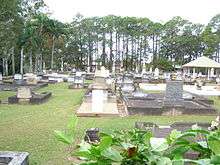
Lawnton Cemetery (also known as Mary Bray Park) is located on Norfolk Avenue (27°16′36″S 152°58′37″E / 27.2766°S 152.9770°E).
Demographics
In the 2011 census, Lawnton recorded a population of 5,356 people, 50.9% female and 49.1% male.
The median age of the Lawnton population was 36 years, 1 year below the national median of 37.
78.3% of people living in Lawnton were born in Australia. The other top responses for country of birth were New Zealand 5.1%, England 4%, Philippines 1%, India 0.9%, South Africa 0.6%.
90.7% of people spoke only English at home; the next most common languages were 0.8% Hindi, 0.5% Tagalog, 0.3% Dutch, 0.3% Italian, 0.3% Spanish.
Transport
Lawnton railway station provides access to regular Queensland Rail City network services to Brisbane and Ipswich, as well as Caboolture and the Sunshine Coast.
Education
References
- ↑ Australian Bureau of Statistics (27 June 2017). "Lawnton (State Suburb)". 2016 Census QuickStats. Retrieved 18 April 2018.

- 1 2 "Lawnton (entry 45446)". Queensland Place Names. Queensland Government. Retrieved 27 July 2014.
- ↑ "Queensland Globe". State of Queensland. Retrieved 20 July 2015.
- ↑ "Pine Rivers township history". Moreton Bay Regional Council. Retrieved 3 July 2014.
- ↑ "Remnants of former acclimatisation society gardens at Lawnton (entry 602703)". Queensland Heritage Register. Queensland Heritage Council. Retrieved 11 July 2013.
- ↑ "Mobile Library". Moreton Bay Regional Council. Archived from the original on 30 January 2018. Retrieved 30 January 2018.
- ↑ "Lawnton SS". Retrieved 1 February 2017.
- ↑ "Schools opening dates". Retrieved 1 February 2017.
- ↑ "Pine Rivers Special School". Retrieved 1 February 2017.
- ↑ "Schools opening dates". Retrieved 1 February 2017.
External links
Coordinates: 27°17′S 152°59′E / 27.283°S 152.983°E