Eildon Dam
| Eildon Dam | |
|---|---|
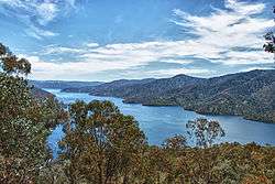 A view of the impounded Lake Eildon, in 2011 | |
 Location of the Eildon Dam in Victoria | |
| Country | Australia |
| Location | Victorian Alps, Victoria |
| Coordinates | 37°11′34″S 145°53′49″E / 37.19278°S 145.89694°ECoordinates: 37°11′34″S 145°53′49″E / 37.19278°S 145.89694°E |
| Purpose | |
| Status | Operational |
| Construction began | 1915 |
| Opening date |
|
| Operator(s) | Goulburn–Murray Water |
| Dam and spillways | |
| Type of dam | Embankment dam |
| Impounds | Goulburn River |
| Height | 84.5 m (277 ft) |
| Length | 1,085 m (3,560 ft) |
| Dam volume | 10,200×103 m3 (360×106 cu ft) |
| Spillway type | Controlled |
| Spillway capacity | 3,356 m3/s (118,500 cu ft/s) |
| Reservoir | |
| Creates | Lake Eildon |
| Total capacity | 3,390,000 ML (750,000×106 imp gal; 900,000×106 US gal) |
| Catchment area | 3,885 km2 (1,500 sq mi) |
| Surface area | 13,832 ha (34,180 acres) |
| Maximum water depth | 79 m (259 ft)[1] |
| Normal elevation | 288.9 m (948 ft) AHD |
| Eildon Hydroelectric Power Station | |
| Coordinates | 37°13′19″S 145°55′17″E / 37.22194°S 145.92139°E |
| Operator(s) | AGL Energy |
| Commission date |
|
| Turbines | Four |
| Installed capacity | 135 MW (181,000 hp) |
| Annual generation | 226 GWh (810 TJ) |
|
Website Lake Eildon at Goulburn–Murray Water | |
The Eildon Dam or Eildon Weir, a rock and earth-fill embankment dam with a controlled spillway across the Goulburn River, is located between the regional towns of Mansfield and Eildon within Lake Eildon National Park, in the Alpine region of Victoria, Australia. The dam's purpose is for the supply of potable water, irrigation, and the generation of hydroelectricity. The impounded reservoir is called Lake Eildon.
Location and features
Designed by the State Rivers and Water Supply Commission of Victoria, construction of the original water storage, which was known as Sugarloaf Reservoir, took place between 1915 and 1929 to provide irrigation water for what was a vast uncultivated area on Victoria's northern plains. The dam was modified in 1929, and again in 1935 to increase the storage capacity to 377,000 megalitres (83×109 imp gal; 100×109 US gal). However, this reservoir was still limited in its capacity to meet the growing demand for water in the Goulburn Valley and to protect farmers during drought years. Following a detailed feasibility study of all possible storage sites on the Goulburn River, it was decided that the existing dam site was the most suitable for construction of a larger dam. In 1951, work began to enlarge the storage to its present capacity. The enlargement was completed in 1955 and the storage was renamed Lake Eildon.[2]
The embankment dam wall is constructed with an earth core and rock fill, rising to a height of 83 metres (272 ft).[3] The core component materials of the wall include 10,200 thousand cubic metres (360×106 cu ft) of rock and earth. With a catchment area of 3,885 square kilometres (1,500 sq mi) that includes the Goulburn, Delatite, Howqua, Big, and Jamieson rivers and several minor tributaries,[4] the reservoir covers an area of 13,832 hectares (34,180 acres). The reservoir has a capacity of 3,390,000 megalitres (746×109 imp gal; 896×109 US gal) with an average depth of 24 metres (79 ft), and can release a maximum outflow of approximately 3,356 cubic metres per second (118,500 cu ft/s) via its controlled spillway. The crest of the uncontrolled spillway is 288.9 metres (948 ft) AHD and is approximately 1,085 metres (3,560 ft) long.[2][3]
Lake Eildon is connected to the metropolitan water supply of Melbourne, the state capital, via a pipeline from the Goulburn River. On average, 91% of the water from Lake Eildon goes to the Goulburn Weir and the Waranga Basin before it flows to irrigators in the Goulburn Valley system.
Power generation
Operated by AGL Energy, Eildon Hydroelectric Power Station is a hydro–electric power station that operates during the irrigation season from August to May; its operation is mainly governed by release of water to meet irrigation demands, but it may also be operated during winter and spring when flood releases can be used to generate electricity. The power station can also be used to meet short term emergency power needs resulting from industrial disputes or plant breakdown elsewhere in the State's power grid. Initially completed as part of the Sugarloaf Reservoir with just 15 megawatts (20,000 hp) of hydro–electric generating power, capacity was increased by 1957 to 120 megawatts (160,000 hp) through the installation of two 60 megawatts (80,000 hp) turbines. The first 67-megawatt (90,000 hp) turbine was commissioned in 1956, and a second in 1957.[5] In addition, there are two 7.5 megawatts (10,100 hp) turbines; these were decommissioned in 1971, but recommissioned in 2001.[6] These smaller turbines were relocated from the former Sugarloaf Power Station on the Eildon Weir,[5] completed in 1929 and in use until work on the larger dam started in 1951.[7] This renovation of the oldest turbines in 2001 led to a generation capacity of 135 megawatts (181,000 hp). A 5,200 megalitres (1.1×10⁹ imp gal; 1.4×10⁹ US gal) pondage below the dam temporarily detains water discharged from the power station and regulates releases downstream to minimise variations in flow due to intermittent power generation. In 1995 a small hydro-electric station with 4.5 megawatts (6,000 hp) output was installed on the pondage.[2][3]
Eildon Power Station has four turbo generators, with a total generating capacity of 150 megawatts (200,000 hp) of electricity. It produces an average of around 225 gigawatt-hours (810 TJ) of electricity per annum.[6]
Drought and recovery
During the drought years in Victoria in the 2000s, Lake Eildon rarely filled and the once-thriving holiday destinations around the lake were unable to attract visitors, leading to considerable economic hardship. Although water is in great demand for agriculture, careful regulation has kept outflows fairly static. During November 2006 the lake dropped to a low of only 15% from the previous year level of 48.3%.[8]
After many years with below average rainfall, 2010 saw Lake Eildon receive above average rainfall and rose from 23% of capacity in May 2010 to be 82.5% as of March 2011.[2]
In film
The nearby town of Bonnie Doon was the location for the holiday scenes in the movie, The Castle.
Gallery
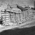 During construction of a new embankment, 1954
 A panoramic mosaic of Lake Eildon, circa 2000.
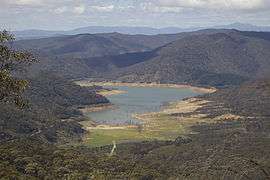 Lake Eildon in circa 2006.
.jpg) Lake Eildon from Merlo's Lookout in early 2007, showing one of the boat ramps now clear of the water.
Lake Eildon from Merlo's Lookout in early 2007, showing one of the boat ramps now clear of the water.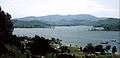 Peppin Point, Nov.2010
See also
References
- ↑ "Eildon Lake fishing: fishing maps and fishing info for Eildon Lake", Fishing Victoria, archived from the original on 17 February 2011, retrieved 31 May 2011
- 1 2 3 4 "Lake Eildon". Goulburn–Murray Water. Archived from the original on 25 September 2014. Retrieved 16 July 2014.
- 1 2 3 "Register of Large Dams in Australia" (Excel (requires download)). Dams information. Australian National Committee on Large Dams. 2010. Retrieved 16 July 2014.
- ↑ "Map of Lake Eildon, VIC". Bonzle Digital Atlas of Australia. Retrieved 16 July 2014.
- 1 2 Edwards, Cecil (1969). Brown Power. A jubilee history of the SECV. State Electricity Commission of Victoria.
- 1 2 "Eildon Power Station". AGL. Archived from the original on 18 September 2006. Retrieved 13 October 2006.
- ↑ Goulburn-Murray Water: Lake Eildon
- ↑ http://www.water.vic.gov.au/monitoring/monthly/archive/monthly_water_report7/storage_levels
External links
- Lake Eildon Tourism Website
- Goulburn-Murray Water - Lake Eildon
- Lake Eildon Challenge multi sports event
| |||||||||||||||||
| |||||||||||||||||
| |||||||||||||||||