Lake Buckhorn, Ohio
| Lake Buckhorn, Ohio | |
|---|---|
| Census-designated place | |
 Lake Buckhorn  Lake Buckhorn | |
| Coordinates: 40°28′28″N 81°54′30″W / 40.47444°N 81.90833°WCoordinates: 40°28′28″N 81°54′30″W / 40.47444°N 81.90833°W | |
| Country | United States |
| State | Ohio |
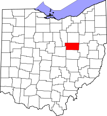
| County | Holmes |
| Township | Mechanic |
| Area | |
| • Total | 2.01 sq mi (5.21 km2) |
| • Land | 1.76 sq mi (4.55 km2) |
| • Water | 0.25 sq mi (0.66 km2) |
| Elevation | 880 ft (270 m) |
| Population (2010) | |
| • Total | 601 |
| • Density | 342/sq mi (132.1/km2) |
| Time zone | UTC-5 (Eastern (EST)) |
| • Summer (DST) | UTC-4 (EDT) |
| Area code(s) | 330 |
| FIPS code | 39-41349 |
| GNIS feature ID | 1077714 |
Lake Buckhorn is a census-designated place (CDP) in Mechanic Township, Holmes County, Ohio, United States. As of the 2010 census it had a population of 601.[1] It is a private, members-only gated community.[2] The community is built around 220-acre (89 ha) Lake Buckhorn, a reservoir impounded in 1967.[2]
Geography
Lake Buckhorn is in south-central Holmes County on a tributary of Doughty Creek, a southwest-flowing tributary of Killbuck Creek and part of the Walhonding River watershed flowing to the Ohio River. Ohio State Route 83 forms the eastern boundary of the community. The highway leads north 8 miles (13 km) to Millersburg, the Holmes county seat, and south 16 miles (26 km) to Coshocton.
According to the U.S. Census Bureau, the Lake Buckhorn CDP has a total area of 2.01 square miles (5.21 km2), of which 1.76 square miles (4.55 km2) are land and 0.25 square miles (0.66 km2), or 12.66%, are water.[1]
References
- 1 2 "Geographic Identifiers: 2010 Census Summary File 1 (G001): Lake Buckhorn CDP, Ohio". American Factfinder. U.S. Census Bureau. Retrieved January 9, 2018.
- 1 2 History of Lake Buckhorn
