Walhonding River
| Walhonding River | |
|---|---|
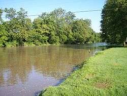 The Walhonding River in Warsaw in 2006 | |
| Country | United States |
| Physical characteristics | |
| Main source | Confluence of the Kokosing and Mohican Rivers, Coshocton County, Ohio |
| River mouth | Joins the Tuscarawas River to form the Muskingum River at Coshocton, Ohio |
| Length | 23.5 mi (37.8 km) |
| Basin features | |
| Basin size | 2,252 sq mi (5,830 km2) |
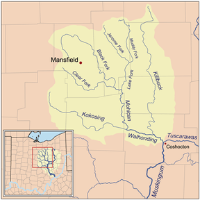
The Walhonding River is a principal tributary of the Muskingum River,[1] 23.5 miles (37.8 km) long,[2] in east-central Ohio in the United States. Via the Muskingum and Ohio Rivers, it is part of the watershed of the Mississippi River. It drains an area of 2,252 square miles (5,833 km²).[2]
The Walhonding flows for its entire length in Coshocton County. It is formed by the confluence of the Mohican River and the Kokosing River and flows generally east-southeast,[3] passing through Mohawk Dam, which was built in the 1930s by the U.S. Army Corps of Engineers for the purpose of flood control in the Muskingum River watershed,[4] and through the towns of Nellie and Warsaw. Downstream of Warsaw it collects Killbuck Creek. It meets the Tuscarawas River at the city of Coshocton to form the Muskingum River.[3]
Variant names
According to the Geographic Names Information System, the Walhonding River has also been known historically as:[5]
- Muskingum River ("West branch")
- Walhandink River
- West Branch of the Muskingum
- White Woman Creek
- White Woman River
- White Womans Creek
- White Womans River
- Whitemans Creek
- Whitewoman Creek
- Whitewomans Creek
- Wolhonding River
[note: its alternate name "White Womans Creek"(var.) was probably originally intended to refer specifically either to the Kokosing River or to the Mohican River [6]; and during that same time-period (mid-1700s), the Walhonding was known only and simply as the "West branch of the Muskingum". [7] The final name "Walhonding" was newly chosen by legislators sometime after the 1820s.]
See also
References
- ↑ Columbia Gazetteer of North America entry Archived 2005-08-19 at the Wayback Machine.
- 1 2 Ohio Department of Natural Resources. A Guide to Ohio Streams. Chapter 10: Major Ohio Watersheds (pdf)
- 1 2
- ↑ Mohawk Dam website
- ↑ U.S. Geological Survey Geographic Names Information System: Walhonding River
- ↑ hand-drawn map circa-1815, private-collection -- which indicates that the village of "Jerometown" was on "Whitewomans Creek"
- ↑ Hutchins, Thos.; surveys and maps mid-1700s