Labu, Temburong
| Labu Mukim Labu | |
|---|---|
| Mukim | |
 Mukim location | |
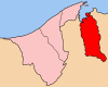 Temburong District in Brunei | |
| Country | Brunei |
| District | Temburong |
| Area[1] | |
| • Total | 292 km2 (113 sq mi) |
| Population (2016)[2] | |
| • Total | 599 |
| • Density | 2.1/km2 (5.3/sq mi) |
| Time zone | UTC+8 (Brunei Standard Time) |
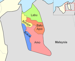
Labu is a mukim in the Temburong District of Brunei. It is located in the north of the Temburong District bordering Brunei Bay to the north, Sarawak (Malaysia) to the east, Mukim Batu Apoi to the south, Mukim Bangar to the south-west and Limbang, Sarawak (Malaysia) to the west. Mukim Labu contains several islands: Pulau Selirong, Pulau Selanjak, Pulau Siarau and Pulau Pituat. Labu has a total area of 292 square kilometres (113 sq mi);[1] as of 2016, Labu had a total population of 599.[2]
Areas and divisions
Mukim Labu includes these following areas:
- Kampong Labu Estate
- Kampong Senukoh
- Kampong Piasau-Piasau
- Kampong Payau
- Kampong Ayam-Ayam
Other locations
Other locations within the mukim include:
- Pulau Selirong
- Pulau Selanjak
- Pulau Siarau
- Pulau Pituat
Border crossing
A road border crossing into Sarawak, Malaysia is located in this mukim, along the road between Bangar and Lawas. Called the Labu checkpoint, the crossing is located at the Brunei-Malaysia border east of Bangar. The Malaysian checkpoint is called Mengkalap; before the new checkpoint at the border was completed, it operated out of a shoplot in Trusan Bazaar, about 8 km from the border towards Lawas.
References
- 1 2 "Jabatan Daerah Temburong, Kementerian Hal Ehwal Dalam Negeri - MUKIM LABU". temburong.gov.bn (in Malay). Retrieved 2018-01-09.
- 1 2 "Data Set Population Temburong Population by Mukims" (XLSX). www.data.gov.bn. Retrieved 2018-01-08.
Coordinates: 4°47′23″N 115°09′55″E / 4.78972°N 115.16528°E