Bokok, Temburong
| Bokok Mukim Bokok | |
|---|---|
| Mukim | |
 Mukim location | |
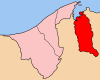 Temburong District in Brunei | |
| Country | Brunei |
| District | Temburong |
| Area[1] | |
| • Total | 136 km2 (53 sq mi) |
| Population (2016)[2] | |
| • Total | 3,583 |
| • Density | 26/km2 (68/sq mi) |
| Time zone | UTC+8 (Brunei Standard Time) |
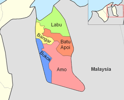
Bokok is a mukim or subdistrict in the Temburong District of Brunei. It is located in the west of the Temburong District to the south, bordering Mukim Bangar to the north-east, Mukim Amo to the east, Sarawak (Malaysia) to the south and Limbang, Sarawak (Malaysia) to the west. Bokok has a total area of 136 square kilometres (53 sq mi);[1] as of 2016, it had a total population of 3,583.[2]
Areas and divisions
Mukim Bokok includes these following areas:
- Kampong Buda-Buda
- Kampong Belais
- Kampong Belais Kecil
- Kampong Paya Bagangan
- Kampong Bokok
- Kampong Meniup
- Kampong Bakarut
- Kampong Simbatang
- Kampong Rataie
- Kampong Perpindahan Rataie
- Kampong Rakyat Jati
- Kampong Kenua
- Kampong Lepong Baru
- Kampong Lepong Lama
- Kampong Semabat Bahagia
- Kampong Semabat
- Kampong Temada
References
- 1 2 "Jabatan Daerah Temburong, Kementerian Hal Ehwal Dalam Negeri - MUKIM BOKOK". temburong.gov.bn (in Malay). Retrieved 2018-01-09.
- 1 2 "Data Set Population Temburong Population by Mukims" (XLSX). www.data.gov.bn. Retrieved 2018-01-08.
Coordinates: 4°38′43″N 115°03′16″E / 4.64528°N 115.05444°E
This article is issued from
Wikipedia.
The text is licensed under Creative Commons - Attribution - Sharealike.
Additional terms may apply for the media files.