Batu Apoi, Temburong
| Batu Apoi Mukim Batu Apoi | |
|---|---|
| Mukim | |
 Mukim location | |
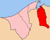 Temburong District in Brunei | |
| Country | Brunei |
| District | Temburong |
| Area[1] | |
| • Total | 222 km2 (86 sq mi) |
| Population (2016)[2] | |
| • Total | 1,595 |
| • Density | 7.2/km2 (19/sq mi) |
| Time zone | UTC+8 (Brunei Darussalam Time) |
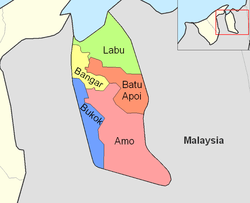
Batu Apoi is a mukim in the Temburong District of Brunei. It is located in the east of the Temburong District to the centre, bordering Mukim Labu to the north, Sarawak (Malaysia) to the east, Mukim Amo to the south and Mukim Bangar to the west. Batu Apoi has a total area of 222 square kilometres (86 sq mi);[1] as of 2016, it had a population of 1,595.[2]
Areas and divisions
Mukim Batu Apoi includes these following areas:
- Kampong Batu Apoi
- Kampong Sungai Radang
- Kampong Peliunan
- Kampong Sungai Bantaian
- Kampong Gadong Baru
- Kampong Luagan
- Kampong Negalang Iring
- Kampong Negalang Unat
- Kampong Lakiun
- Kampong Tanjong Bungar
- Kampong Lamaling
- Kampong Selapon
- Kampong Sekurop
References
- 1 2 "Jabatan Daerah Temburong, Kementerian Hal Ehwal Dalam Negeri - MUKIM BATU APOI". temburong.gov.bn (in Malay). Retrieved 2018-01-09.
- 1 2 "Data Set Population Temburong Population by Mukims" (XLSX). www.data.gov.bn. Retrieved 2018-01-08.
Coordinates: 4°40′56″N 115°11′30″E / 4.68222°N 115.19167°E
This article is issued from
Wikipedia.
The text is licensed under Creative Commons - Attribution - Sharealike.
Additional terms may apply for the media files.