Kuala Belait, Belait
| Kuala Belait Mukim Kuala Belait | |
|---|---|
| Mukim (Subdistrict) | |
| Country | Brunei |
| Daerah (District) | Belait |
| Further subdivisions |
Kampong (Village)
|
| Government | |
| • Penghulu (Headman) | Pungut bin Ali |
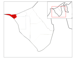
Kuala Belait (locally known as Mukim Kuala Belait) is a mukim or subdistrict of Belait District, Brunei.[1] It is also the westernmost mukim in the country. Kuala Belait is bounded by the South China Sea to the north, Seria to the east, Kuala Balai to the south-east and the Malaysian state of Sarawak to the south and west. Kuala Belait is headed by a Penghulu (literally 'Headman), and the incumbent is Pungut bin Ali.[2][3]
Subdivisions
Kuala Belait is further divided into kampong subdivisions, where each has its own postcode. It consists of the following:[4]
| Kampong[4] | Postcode[5] |
|---|---|
| Pekan Kuala Belait | KA1131 |
| Kampong Mumong 'A' | KA1531 |
| Kampong Mumong 'B' | KA1731 |
| Kampong Pandan 'A' | KA1931 |
| Kampong Pandan 'B' | KA2931 |
| Kampong Pandan 'C' | KA2131 |
| Kampong Sungai Melilit | KA2731 |
| Kampong Sungai Teraban | KA3331 |
Pekan Kuala Belait is the municipal area of Kuala Belait town. The following villages might have been once separate subdivisions but has since been subsumed under Pekan Kuala Belait:
- Kampong Pekan Belait
- Kampong Melayu Asli
- Kampong Melayu Baru
- Kampong China
- Kampong Temenggong
- Kampong Lubok Palam
- Kampong Sungai Duhon
Kampong Mumong 'A' and Kampong Mumong 'B' are collectively known as Mumong, in which it is considered a suburb of Kuala Belait. Kampong Mumong 'A' can be found Skim Tanah Kurnia Rakyat Jati Mumong, a public housing area. Kampong Mumong 'B' is also known by the postcode area name Kampong Mumong Selatan.[5]
Similarly, Kampong Pandan 'A', Kampong Pandan 'B' and Kampong Pandan 'C' constitute the suburb Kampong Pandan. Perumahan Negara Pandan is another public housing area and spread across these three subdivisions.
Even though it is named with the term 'Kampong' and has its own postcode, Kampong Sungai Melilit has no known population.
Other Locations
Other locations within the mukim include:
- Sungai Tujoh - the location of the customs/immigration point at the border with Sarawak, Malaysia
- Rasau - the gas field operated by Brunei Shell Petroleum
- The mouth of the Belait River, the longest river in Brunei
- Istana Mangellela, the residence of Sultan Hassanal Bolkiah in Kuala Belait
See also
References
- ↑ PDF format, belait district - Information Department
- ↑ "Direktori Penghulu, Ketua Kampung, dan Ketua Rumah Panjang - All contacts". belait.gov.bn. Retrieved 2017-09-10.
- ↑ "Meeting to discuss current issues – Borneo Bulletin Online". Borneo Bulletin Online. 2017-09-06. Retrieved 2017-09-10.
- 1 2 "Geoportal - Survey Department". survey.gov.bn. Retrieved 2017-09-10.
- 1 2 "Brunei Postal Services - postcodes". post.gov.bn. Retrieved 2017-09-10.