Graciosa, Canary Islands
 La Graciosa from Mirador Del Rio | |
_-_OSM_Mapnik.svg.png) La Graciosa Location with Lanzarote 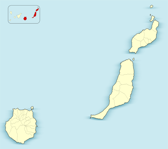 La Graciosa La Graciosa (Province of Las Palmas)  La Graciosa La Graciosa (Canary Islands)  La Graciosa La Graciosa (Spain, Canary Islands) | |
| Geography | |
|---|---|
| Coordinates | 29°15′00″N 13°30′29″W / 29.250°N 13.508°WCoordinates: 29°15′00″N 13°30′29″W / 29.250°N 13.508°W |
| Archipelago | Chinijo Archipelago, Canary Islands |
| Area | 29.05 km2 (11.22 sq mi) |
| Highest elevation | 266 m (873 ft) |
| Highest point | Agujas Grandes |
| Administration | |
|
Spain | |
| Autonomous Community |
|
| Province | Las Palmas |
| Municipality | Teguise |
| Largest settlement | Caleta de Sebo (pop. 679) |
| Demographics | |
| Population | 752 (2017[1]) |
| Pop. density | 25.88 /km2 (67.03 /sq mi) |
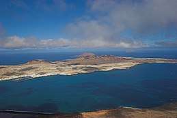
Graciosa Island or commonly La Graciosa (pronounced [la ɣɾaˈθjosa]; Spanish for "graceful") is a volcanic island in the Canary Islands of Spain, located 2 km (1.2 mi) north of the island of Lanzarote across the strait named El Río. It was formed by the Canary hotspot. The island is part of the Chinijo Archipelago and the Chinijo Archipelago Natural Park (Parque Natural del Archipiélago Chinijo).[2][3] It is administrated by the municipality of Teguise. The only two settlements are Caleta de Sebo in the southeastern part of the island and summer-residence Casas de Pedro Barba.
The population is about 752. Tourism is the main industry along with fishing. Every year, tourists flock to the island for its tempered climate and its sandy volcanic coasts. The island has a school, lyceum, post office, supermarkets, medical center, pharmacy, a Bankia bank branch (in danger of closure as of September 2013[4] but still there in February 2016), port, beaches, bar-restaurants and a square.
Streets and roads on La Graciosa are unpaved sand. Motor vehicles are strictly prohibited and limited to a handful of licensed vehicles for special purposes. Access to the Island is by a 35-minute ferry crossing from Orzola on Lanzarote to the harbour in the village. There is a campsite on the Island situated on Playa del Salado at the western edge of Caleta del Sebo.
Geographical features
The island is extremely arid and entirely made up of bushes and dry soil. Its length is 8 km (5.0 mi) and the width is 4 km (2.5 mi), making an area of 29 km2 (11 sq mi). There are no natural water sources on the island; desalinated water has been piped directly from neighbouring Lanzarote since 2001.
There are several isolated mountains on the island, the tallest of which is Agujas Grandes rising to 266 m (873 ft). The second tallest is Agujas Chicas at 228 m (748 ft). Playa de la Cocina is a well known beach in the southwestern part of the island.
.jpg)
References
| Wikimedia Commons has media related to La Graciosa. |
- ↑ Instituto Nacional de Estadística
- ↑ Protected Natural Areas Archived 2015-04-17 at the Wayback Machine.
- ↑ Boletín Oficial de Canarias, pages 9723 and 9865-7
- ↑ El Cabildo pide reconsiderar el cierre de Bankia en La Graciosa, Canarias 7, Carlos Inza, 4 september 2013.
- R. Pott, J. Hüppe, W. Wildpret de la Torre, Die Kanarischen Inseln. Natur- und Kulturlandschaften, Ulmer Eugen Verlag, 2003, ISBN 9783800132843
Islands and provinces of the Canary Islands | ||
|---|---|---|
| Main islands |  | |
| Other islands | ||
| Provinces | ||