Montaña Clara
 Montaña Clara Island | |
_-_OSM_Mapnik.svg.png) Montaña Clara Location with Lanzarote 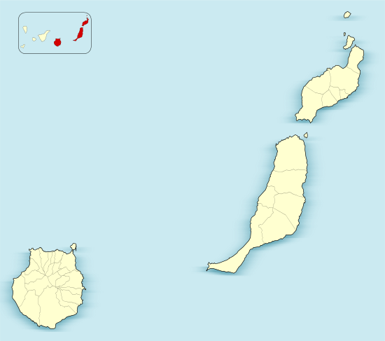 Montaña Clara Montaña Clara (Province of Las Palmas)  Montaña Clara Montaña Clara (Canary Islands)  Montaña Clara Montaña Clara (Spain, Canary Islands) | |
| Geography | |
|---|---|
| Coordinates | 29°17′56″N 13°32′06″W / 29.299°N 13.535°WCoordinates: 29°17′56″N 13°32′06″W / 29.299°N 13.535°W |
| Archipelago | Chinijo Archipelago |
| Area | 1.33 km2 (0.51 sq mi) |
| Highest elevation | 256 m (840 ft) |
| Administration | |
| Autonomous Community | Canary Islands |
| Province | Las Palmas |
| Municipality | Teguise |
| Demographics | |
| Population | 0 (2013) |
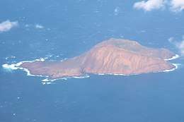
Montaña Clara (pronounced [monˈtaɲa ˈklaɾa]) (Spanish meaning "light-colored mountain") is a small uninhabited islet belonging to the Chinijo Archipelago, in the northeastern part of the Canary Islands, only a short distance (about 2 km (1.2 mi)) northwest of La Graciosa. The islet area is only 1.33 km². The highest point of the island is 256 m (840 ft) above sea level.
Being a refuge for marine birds, the island is part of the integral nature reserve Los Islotes, which is part of the natural park Chinijo Archipelago.[1][2] In August 2007 the island was offered for sale by the heirs to the last owner, Mariano López Socas, who was mayor of a small Lanzarote town; asking price: 9 million euros.[3]
References
- ↑ Protected Natural Areas Archived 2010-02-12 at the Wayback Machine.
- ↑ Boletín Oficial de Canarias, pages 9723 and 9865-7
- ↑ Guardian Unlimited
External links
Islands and provinces of the Canary Islands | ||
|---|---|---|
| Main islands |  | |
| Other islands | ||
| Provinces | ||
This article is issued from
Wikipedia.
The text is licensed under Creative Commons - Attribution - Sharealike.
Additional terms may apply for the media files.