L'Islet, Quebec
| L'Islet | |
|---|---|
| Municipality | |
 Church of Notre-Dame-Bonsecours | |
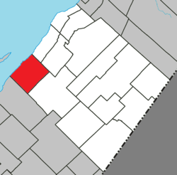 Location within L'Islet RCM | |
 L'Islet Location in southern Quebec | |
| Coordinates: 47°06′N 70°21′W / 47.100°N 70.350°WCoordinates: 47°06′N 70°21′W / 47.100°N 70.350°W[1] | |
| Country |
|
| Province |
|
| Region | Chaudière-Appalaches |
| RCM | L'Islet |
| Constituted | January 1, 2000 |
| Government[2] | |
| • Mayor | André Caron |
| • Federal riding |
Montmagny—L'Islet— Kamouraska—Rivière- du-Loup |
| • Prov. riding | Côte-du-Sud |
| Area[2][3] | |
| • Total | 176.30 km2 (68.07 sq mi) |
| • Land | 120.02 km2 (46.34 sq mi) |
| Population (2011)[3] | |
| • Total | 3,999 |
| • Density | 33.3/km2 (86/sq mi) |
| • Pop 2006-2011 |
|
| • Dwellings | 1,907 |
| Time zone | UTC−5 (EST) |
| • Summer (DST) | UTC−4 (EDT) |
| Postal code(s) | G0R 2C0 |
| Area code(s) | 418 and 581 |
| Highways |
|
| Website |
www |
L'Islet is a municipality within L'Islet Regional County Municipality in the Chaudière-Appalaches region of Quebec, Canada.
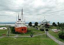
It is located on the south shore of the Saint Lawrence River halfway between Quebec City and Rivière-du-Loup. The Musée Maritime du Québec (Quebec Marine Museum) is located there on Route 132.
History and geography
The current town of L'Islet was formed in 2000 with the merger of the former city of L'Islet, the municipality of L'Islet-sur-Mer, and the parish municipality of Saint-Eugène.
The municipality got its name from a small island in the river near the village of L'Islet-sur-Mer.
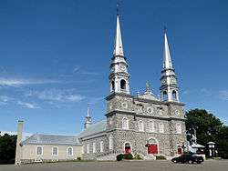
The Notre-Dame-de-Bonsecours church, built 1768, is classified as important historical building.
The town hosts many small events during the year such as the Festival Guitares en fête, La Parades des Berlots, and the L'Islet Car Show.
Local rivers include the:
- Tortue River
- Bras St-Nicolas River
- Talbot River
Notable people
- Adine Fafard-Drolet, singer and founder of a music school
- Louis Pierre Blanchet, founder of St. Charles, Missouri USA in 1769.
See also
References
External links

- (in French) Official website
Adjacent Municipal Subdivisions | |
|---|---|
| Cities & Towns | |
|---|---|
| Municipalities | |
| Parishes | |
| |