Lügde
| Lügde | ||
|---|---|---|
| ||
 Lügde Location of Lügde within Lippe district 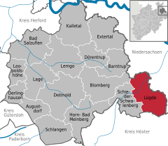  | ||
| Coordinates: 51°57′00″N 09°15′00″E / 51.95000°N 9.25000°ECoordinates: 51°57′00″N 09°15′00″E / 51.95000°N 9.25000°E | ||
| Country | Germany | |
| State | North Rhine-Westphalia | |
| Admin. region | Detmold | |
| District | Lippe | |
| Government | ||
| • Mayor | Heinrich Josef Reker (non-party) | |
| Area | ||
| • Total | 88.64 km2 (34.22 sq mi) | |
| Elevation | 105 m (344 ft) | |
| Population (2016-12-31)[1] | ||
| • Total | 9,624 | |
| • Density | 110/km2 (280/sq mi) | |
| Time zone | CET/CEST (UTC+1/+2) | |
| Postal codes | 32668–32676 | |
| Dialling codes | 05281, 05283 | |
| Vehicle registration | LIP | |
| Website | luegde.de | |

Lügde [ˈlʏçtʰə] (![]()
The first written issue of Lügde appears in 784, in the annals of the Frankish Empire, when Charlemagne visited the village during the Saxon Wars. During this wars Charlemagne celebrated his first Christmas in Saxony in Lügde, and the site then became the location of the first church to be built in Saxony. The gothic church was rebuilt in the 12th century and it is still standing today. The church is known as the Kirche St. Kilian.
References
- ↑ "Amtliche Bevölkerungszahlen" (in German). Landesbetrieb Information und Technik NRW. Retrieved 2018-02-24.
External links
- Official website

- Pumped-storage hydroelectric power plants in natural resources (in German)
- Natural FFH resources (Schieder-Schwalenberger Wald) in danger (in German)
Towns and municipalities in Lippe | ||
|---|---|---|
This article is issued from
Wikipedia.
The text is licensed under Creative Commons - Attribution - Sharealike.
Additional terms may apply for the media files.