Detmold (region)
| Regierungsbezirk Detmold | |
|---|---|
| Regierungsbezirk | |
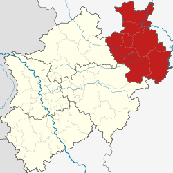 Map of North Rhine-Westphalia highlighting the Regierungsbezirk of Regierungsbezirk Detmold | |
| Country | Germany |
| State | North Rhine-Westphalia |
| Region seat | Detmold |
| Area | |
| • Total | 6,518.14 km2 (2,516.67 sq mi) |
| Population (31 December 2016)[1] | |
| • Total | 2,054,205 |
| • Density | 320/km2 (820/sq mi) |
| Website | www.brdt.nrw.de |
Detmold (German pronunciation: [ˈdɛtmɔlt]) is one of the five Regierungsbezirks of North Rhine-Westphalia, Germany, located in the north-east of the state. It is congruent with the administratively not existent area of Ostwestfalen-Lippe (OWL) (East Westphalia-Lippe).
The Regierungsbezirk was created in 1947 when the former state of Lippe was incorporated into North Rhine-Westphalia by merging the former Regierungsbezirk Minden with the territory of Lippe-Detmold. The Regierungsbezirk Minden dates back to 1815, when the municipality type Regierungsbezirk was created initially.
Location
The Regierungsbezirk Detmold is located in the north-east of North Rhine-Westphalia and therefore it forms the area where the German low mountains are divided from the North German Plain. As the Regierungsbezirk has an expanse of circa 6,500 km² it is one fifth of the area of North Rhine-Westphalia. North and east of the Regierungsbezirk there is the German state of Lower Saxony, south there is the state of Hessen. At the western border there is the Regierungsbezirk of Arnsberg and the Regierungsbezirk of Münster.
Administration
The administration is located in Detmold in the district of Lippe. Since 21 July 2005 Marianne Thomann-Stahl (FDP) is the leader of the administration (Regierungspräsidentin).
Administrative divisions
The Regierungsbezirk consists of six districts with 69 municipalities, and of one district-free city.
| Kreise (districts) |
Kreisfreie Städte (district-free cities) |
|---|---|
History
The Regierungsbezirk Detmold has two historical roots:
- the East Westphalian part (almost 80% of the area) belonged to the former Prussian Province of Westphalia and there it formed the unit of the Regierungsbezirk Minden. In 1946 the Prussian Province formed the new state of North Rhine-Westphalia along with the northern Rhineland.
- the region roughly around the today's district of Lippe was called Land Lippe until 1947 and it was a separate German State just like Prussia. Until 1918 it had been a principality (Fürstentum), then a Free State (Freistaat) and so it has a different historical background than East Westphalia.
References
- ↑ "Amtliche Bevölkerungszahlen" (in German). Landesbetrieb Information und Technik NRW. Retrieved 2018-02-24.
External links
Administrative regions (Regierungsbezirk) in North Rhine-Westphalia | |||
|---|---|---|---|