Kalletal
| Kalletal | ||
|---|---|---|
| ||
 Kalletal Location of Kalletal within Lippe district 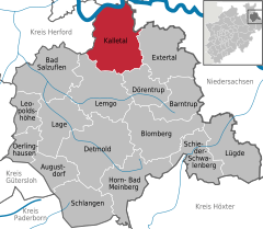  | ||
| Coordinates: 52°07′00″N 08°56′59″E / 52.11667°N 8.94972°ECoordinates: 52°07′00″N 08°56′59″E / 52.11667°N 8.94972°E | ||
| Country | Germany | |
| State | North Rhine-Westphalia | |
| Admin. region | Detmold | |
| District | Lippe | |
| Government | ||
| • Mayor | Andreas Karger, died at 21 February 2015 - since vacancy (CDU) | |
| Area | ||
| • Total | 112.42 km2 (43.41 sq mi) | |
| Elevation | 214 m (702 ft) | |
| Population (2016-12-31)[1] | ||
| • Total | 13,818 | |
| • Density | 120/km2 (320/sq mi) | |
| Time zone | CET/CEST (UTC+1/+2) | |
| Postal codes | 32689 | |
| Dialling codes | 05264 | |
| Vehicle registration | LIP | |
| Website | www.kalletal.de | |

Kalletal is a municipality in the Lippe district of North Rhine-Westphalia, Germany, with c. 13,800 inhabitants (2013).
Comprising villages (Ortschaften)
- Asendorf
- Bavenhausen
- Bentorf
- Brosen
- Erder
- Heidelbeck
- Henstorf
- Hohenhausen
- Kalldorf
- Langenholzhausen
- Lüdenhausen
- Osterhagen
- Stemmen
- Talle
- Varenholz
- Westorf
References
- ↑ "Amtliche Bevölkerungszahlen" (in German). Landesbetrieb Information und Technik NRW. Retrieved 2018-02-24.
External links
- Official website (in German)
Towns and municipalities in Lippe | ||
|---|---|---|
This article is issued from
Wikipedia.
The text is licensed under Creative Commons - Attribution - Sharealike.
Additional terms may apply for the media files.