Dörentrup
| Dörentrup | ||
|---|---|---|
| ||
 Dörentrup Location of Dörentrup within Lippe district 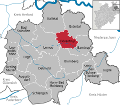  | ||
| Coordinates: 52°01′59″N 09°00′00″E / 52.03306°N 9.00000°ECoordinates: 52°01′59″N 09°00′00″E / 52.03306°N 9.00000°E | ||
| Country | Germany | |
| State | North Rhine-Westphalia | |
| Admin. region | Detmold | |
| District | Lippe | |
| Government | ||
| • Mayor | Friedrich Ehlert (CDU) | |
| Area | ||
| • Total | 49.79 km2 (19.22 sq mi) | |
| Elevation | 130 m (430 ft) | |
| Population (2016-12-31)[1] | ||
| • Total | 7,787 | |
| • Density | 160/km2 (410/sq mi) | |
| Time zone | CET/CEST (UTC+1/+2) | |
| Postal codes | 32694 | |
| Dialling codes | 0 52 65 | |
| Vehicle registration | LIP | |
| Website | www.doerentrup-lippe.de | |

Dörentrup is a municipality in the Lippe district of North Rhine-Westphalia, Germany. It has an area of 49.79 km² and c. 8,000 inhabitants (2013).
The name is derived from the Low German word for hill passes, Dören.
Night lighting scheme
A remarkable feature in this village is its night lighting scheme. Every night at 11 pm, all street lights turn off. Inhabitants can then request that lights be turned back on as needed by sending a code to a special phone number called Dial4light. Each street has its own code that can be found either online on a specific website or on each light post. This is intended to reduce energy use, save money, respect the nocturnal fauna and avoid light pollution.
References
- ↑ "Amtliche Bevölkerungszahlen" (in German). Landesbetrieb Information und Technik NRW. Retrieved 2018-02-24.
External links
- Official website (in German)
- Dial4Light : http://www.travelbugholiday.com/?p=1672
- BBC video about Dial4Light : http://news.bbc.co.uk/2/hi/europe/7796800.stm
| Wikimedia Commons has media related to Dörentrup. |
Towns and municipalities in Lippe | ||
|---|---|---|
This article is issued from
Wikipedia.
The text is licensed under Creative Commons - Attribution - Sharealike.
Additional terms may apply for the media files.