Kopperston, West Virginia
| Kopperston | |
|---|---|
| Census-designated place (CDP) | |
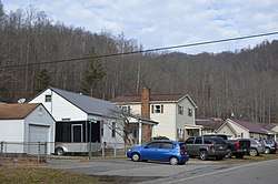 WV 85 at 74th Street | |
 Kopperston Location within the state of West Virginia | |
| Coordinates: 37°44′59″N 81°34′3″W / 37.74972°N 81.56750°WCoordinates: 37°44′59″N 81°34′3″W / 37.74972°N 81.56750°W | |
| Country | United States |
| State | West Virginia |
| County | Wyoming |
| Area[1] | |
| • Total | 1.916 sq mi (4.96 km2) |
| • Land | 1.907 sq mi (4.94 km2) |
| • Water | 0.009 sq mi (0.02 km2) |
| Population (2010)[2] | |
| • Total | 616 |
| • Density | 320/sq mi (120/km2) |
| Time zone | UTC-5 (Eastern (EST)) |
| • Summer (DST) | UTC-4 (EDT) |
| ZIP codes | 24854 |
Kopperston (also Kopperstone) is a census-designated place (CDP) in Wyoming County, West Virginia, United States. Its elevation is 1,660 feet (506 m).[3] Kopperston once had a post office, which closed on March 10, 2007.[4] As of the 2010 census, its population was 616.[2]
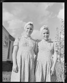
Twin daughters of miner. Koppers Coal Division, Kopperston Mine (19. August 1946)
Climate
The climate in this area is characterized by hot, humid summers and generally mild to cool winters. According to the Köppen Climate Classification system, Kopperston has a humid subtropical climate, abbreviated "Cfa" on climate maps.[5]
References
- ↑ "US Gazetteer files: 2010, 2000, and 1990". United States Census Bureau. 2011-02-12. Retrieved 2011-04-23.
- 1 2 "American FactFinder". United States Census Bureau. Archived from the original on September 11, 2013. Retrieved 2011-05-14.
- ↑ Geographic Names Information System Feature Detail Report, Geographic Names Information System, 1980-06-27. Accessed 2008-05-25.
- ↑ "Postmaster Finder - Post Offices by ZIP Code". United States Postal Service. Retrieved September 26, 2011.
- ↑ Climate Summary for Kopperston, West Virginia
External links
Municipalities and communities of Wyoming County, West Virginia, United States | ||
|---|---|---|
| City | 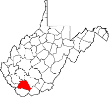 | |
| Towns | ||
| CDPs | ||
| Unincorporated communities |
| |
| Footnotes | ‡This populated place also has portions in an adjacent county or counties | |
This article is issued from
Wikipedia.
The text is licensed under Creative Commons - Attribution - Sharealike.
Additional terms may apply for the media files.