Edith, West Virginia
| Edith | |
|---|---|
| Unincorporated community | |
 Edith Location within the state of West Virginia  Edith Edith (the US) | |
| Coordinates: 37°40′36″N 81°36′26″W / 37.67667°N 81.60722°WCoordinates: 37°40′36″N 81°36′26″W / 37.67667°N 81.60722°W | |
| Country | United States |
| State | West Virginia |
| County | Wyoming |
| Elevation | 1,345 ft (410 m) |
| Time zone | UTC-5 (Eastern (EST)) |
| • Summer (DST) | UTC-4 (EDT) |
| GNIS ID | 1554373[1] |
Edith is an unincorporated community in Wyoming County, West Virginia, along the Laurel Fork.[2]
References
- ↑ U.S. Geological Survey Geographic Names Information System: Edith, West Virginia
- ↑ West Virginia Atlas & Gazetteer. Yarmouth, Me.: DeLorme. 1997. p. 58. ISBN 0-89933-246-3.
Municipalities and communities of Wyoming County, West Virginia, United States | ||
|---|---|---|
| City | 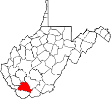 | |
| Towns | ||
| CDPs | ||
| Unincorporated communities |
| |
| Footnotes | ‡This populated place also has portions in an adjacent county or counties | |
This article is issued from
Wikipedia.
The text is licensed under Creative Commons - Attribution - Sharealike.
Additional terms may apply for the media files.