Knoxville, Alabama
| Knoxville, Alabama | |
|---|---|
| Unincorporated community | |
 Knoxville  Knoxville | |
| Coordinates: 32°59′32″N 87°47′26″W / 32.99222°N 87.79056°WCoordinates: 32°59′32″N 87°47′26″W / 32.99222°N 87.79056°W | |
| Country | United States |
| State | Alabama |
| County | Greene |
| Elevation | 289 ft (88 m) |
| Time zone | UTC−6 (Central (CST)) |
| • Summer (DST) | UTC−5 (CDT) |
| ZIP code | 35469 |
| Area code(s) | 205 |
| GNIS feature ID | 156570[1] |
Knoxville is an unincorporated community in Greene County, Alabama, United States. Knoxville is located at the junction of Interstates 20 and 59 with U.S. Routes 11 and 43, 11.9 miles (19.2 km) north-northeast of Eutaw. Knoxville had a post office until it closed on August 29, 2009; it still has its own ZIP code, 35469.[2][3]
Notable people
- James Hardy, former professional basketball player for the New Orleans Jazz
- William W. May, athlete who competed in the 1908 Summer Olympics
References
- ↑ "Knoxville". Geographic Names Information System. United States Geological Survey.
- ↑ United States Postal Service (2012). "USPS – Look Up a ZIP Code". Retrieved 2012-02-15.
- ↑ "Postmaster Finder – Post Offices by ZIP Code". United States Postal Service. Retrieved June 5, 2013.
Municipalities and communities of Greene County, Alabama, United States | ||
|---|---|---|
| Cities | 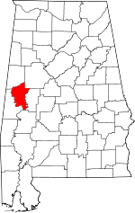 | |
| Towns | ||
| Unincorporated communities | ||
This article is issued from
Wikipedia.
The text is licensed under Creative Commons - Attribution - Sharealike.
Additional terms may apply for the media files.