Clinton, Alabama
| Clinton, Alabama | |
|---|---|
| Unincorporated community | |
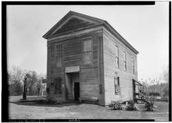 Masonic Temple, photographed as part of the Historic American Buildings Survey | |
 Clinton  Clinton | |
| Coordinates: 32°54′49″N 87°59′33″W / 32.91361°N 87.99250°WCoordinates: 32°54′49″N 87°59′33″W / 32.91361°N 87.99250°W | |
| Country | United States |
| State | Alabama |
| County | Greene |
| Elevation | 161 ft (49 m) |
| Time zone | UTC-6 (Central (CST)) |
| • Summer (DST) | UTC-5 (CDT) |
| ZIP code | 35448 |
| Area code(s) | 205 |
| GNIS feature ID | 116272[1] |
Clinton is an unincorporated community in Greene County, Alabama, United States. Clinton is located at the junction of Alabama routes 14 and 39, 7.9 miles (12.7 km) northwest of Eutaw. Clinton has a post office with ZIP code 35448.[2][3]
References
- ↑ "Clinton". Geographic Names Information System. United States Geological Survey.
- ↑ United States Postal Service (2012). "USPS - Look Up a ZIP Code". Retrieved 2012-02-15.
- ↑ "Postmaster Finder - Post Offices by ZIP Code". United States Postal Service. Retrieved June 4, 2013.
Municipalities and communities of Greene County, Alabama, United States | ||
|---|---|---|
| Cities | 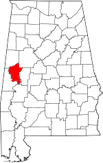 | |
| Towns | ||
| Unincorporated communities | ||
This article is issued from
Wikipedia.
The text is licensed under Creative Commons - Attribution - Sharealike.
Additional terms may apply for the media files.