Klettgau
| Klettgau | ||
|---|---|---|
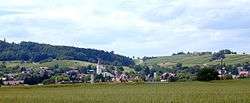 View of Erzingen | ||
| ||
 Klettgau Location of Klettgau within Waldshut district 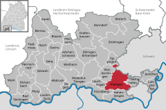  | ||
| Coordinates: 47°39′30″N 08°25′22″E / 47.65833°N 8.42278°ECoordinates: 47°39′30″N 08°25′22″E / 47.65833°N 8.42278°E | ||
| Country | Germany | |
| State | Baden-Württemberg | |
| Admin. region | Freiburg | |
| District | Waldshut | |
| Government | ||
| • Mayor | Volker Jungmann | |
| Area | ||
| • Total | 45.87 km2 (17.71 sq mi) | |
| Elevation | 409 m (1,342 ft) | |
| Population (2017-12-31)[1] | ||
| • Total | 7,573 | |
| • Density | 170/km2 (430/sq mi) | |
| Time zone | CET/CEST (UTC+1/+2) | |
| Postal codes | 79771 | |
| Dialling codes | 07742 | |
| Vehicle registration | WT | |
| Website | www.klettgau.de | |
Klettgau is a municipality in the district of Waldshut in Baden-Württemberg, Germany. It is the centre of the Klettgau historical region stretching across the Swiss border into the cantons of Aargau, Schaffhausen and Zürich.
The municipal area includes the villages of Bühl, Erzingen, Geißlingen, Grießen, Rechberg, Riedern am Sand, and Weisweil.
Geography
Klettgau is located on the Klingengraben and Schwarzbach creeks. In the east it borders on the Swiss municipalities of Trasadingen, Wilchingen and Wasterkingen. The neighbouring German municipalities are Wutöschingen, Lauchringen, Küssaberg, and Hohentengen am Hochrhein in the west, as well as Dettighofen in the east. There is a border crossing into Switzerland on the road from Erzingen to Trasadingen.
The municipal area comprises the villages of Bühl, Erzingen, Geißlingen, Grießen, Rechberg, Riedern am Sand, and Weisweil. Erzingen, Bühl and Riedern am Sand are part of the Baden wine region.
History
Erzingen was already mentioned as villa Arcingen in a 876 deed, a Swabian possession held by the Benedictie abbey of Rheinau. In 1486 it was occupied by the forces of the Old Swiss Confederacy on a campaign into the Landgraviate of Klettgau. The immediate landgraviate was inherited by the House of Schwarzenberg in 1687 with their residence in Tiengen, and elevated to a principality by Emperor Leopold I in 1694. After the Schwarzenberg landgraviate was mediatised in 1806, the lordship fell to the Grand Duchy of Baden in 1812.
The present-day municipality was established in a 1971 administrative reform. Bühl and Geißlingen were incorporated in 1975.
Politics
Seats in the municipal assembly (Gemeinderat) as of 2009 local elections:
International relations
Klettgau is twinned with:
Notable people
- Maximilian Stoll (1742–1787), physician
References
- ↑ "Bevölkerung nach Nationalität und Geschlecht am 31. Dezember 2017". Statistisches Landesamt Baden-Württemberg (in German). 2018.
External links
- (in German) Municipal website
| Wikimedia Commons has media related to Klettgau (Gemeinde). |
| Ecclesiastical |  | |
|---|---|---|
| Secular | ||
| Prelates | ||
| Counts Lords |
| |
| Cities | ||
Circles est. 1500: Bavarian, Swabian, Upper Rhenish, Lower Rhenish–Westphalian, Franconian, (Lower) Saxon Circles est. 1512: Austrian, Burgundian, Upper Saxon, Electoral Rhenish · Unencircled territories | ||