Lauchringen
| Lauchringen | ||
|---|---|---|
| ||
 Lauchringen Location of Lauchringen within Waldshut district 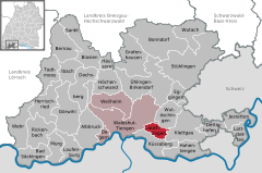  | ||
| Coordinates: 47°37′50″N 08°18′16″E / 47.63056°N 8.30444°ECoordinates: 47°37′50″N 08°18′16″E / 47.63056°N 8.30444°E | ||
| Country | Germany | |
| State | Baden-Württemberg | |
| Admin. region | Freiburg | |
| District | Waldshut | |
| Government | ||
| • Mayor | Thomas Schäuble | |
| Area | ||
| • Total | 12.76 km2 (4.93 sq mi) | |
| Elevation | 360 m (1,180 ft) | |
| Population (2017-12-31)[1] | ||
| • Total | 7,698 | |
| • Density | 600/km2 (1,600/sq mi) | |
| Time zone | CET/CEST (UTC+1/+2) | |
| Postal codes | 79787 | |
| Dialling codes | 07741 | |
| Vehicle registration | WT | |
| Website | www.lauchringen.de | |


Lauchringen
Lauchringen is a village in the county of Waldshut in Baden-Württemberg in Germany. It is divided in two districts: Oberlauchringen and Unterlauchringen.
Geography
Lauchringen lies on the Rhine Plain in the lower Klettgau at the foot of the Küssaberg with its castle of Küssaburg, one of the landmarks of the region.
References
- ↑ "Bevölkerung nach Nationalität und Geschlecht am 31. Dezember 2017". Statistisches Landesamt Baden-Württemberg (in German). 2018.
External links
| Wikimedia Commons has media related to Lauchringen. |
- Official website

This article is issued from
Wikipedia.
The text is licensed under Creative Commons - Attribution - Sharealike.
Additional terms may apply for the media files.