Kintersburg Covered Bridge
|
Kintersburg Covered Bridge | |
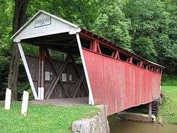 The Kintersburg Covered Bridge over Crooked Creek | |
  | |
| Location | Kintersburg, Pennsylvania, United States |
|---|---|
| Coordinates | 40°42′48″N 79°4′53″W / 40.71333°N 79.08139°WCoordinates: 40°42′48″N 79°4′53″W / 40.71333°N 79.08139°W |
| Built | 1877 |
| Architect | J.S. Fleming[1] |
| NRHP reference # | 79002241 |
| Added to NRHP | August 3, 1979[1] |
The Kintersburg Covered Bridge is a covered bridge spanning Crooked Creek in Rayne Township, Indiana County, Pennsylvania, United States. Built in 1877, it is one of four covered bridges in the county, and is the only one with a Howe truss design. It is 62-foot-long (19 m).[1] The Howe design is rather rare in covered bridges. The Kintersburg Bridge is one of only five in the state of Pennsylvania with that design.[2] The other four are the McConnell's Mill Covered Bridge in Lawrence County, Mean's Ford Covered Bridge in Bucks County, St. Mary's Covered Bridge in Huntingdon County, and the Thomas Mill Covered Bridge in Philadelphia County.[3]
Because of its Howe design, the bridge was placed on the National Register of Historic Places in 1979.
Notes
- 1 2 3 Evans & Evans, p. 148
- ↑ Evans & Evans, pp. 188-189
- ↑ "National Historic Landmarks & National Register of Historic Places in Pennsylvania" (Searchable database). CRGIS: Cultural Resources Geographic Information System. Note: This includes Susan M. Zacher (n.d.). "National Register of Historic Places Inventory Nomination Form: Covered Bridges of Indiana County (Kintersburg Covered Bridge)" (PDF). Retrieved 2011-12-04.
Sources
- Evans, Benjamin D., and June R. Evans Pennsylvania's Covered Bridges, University of Pittsburgh Press, 2001, ISBN 0-8229-5764-7.
External links
| Topics |   | |
|---|---|---|
| Lists by county |
| |
| Lists by city | ||
| Other lists | ||
| ||